Great Blue Ridge Motorcycle Ride Near Highlands, NC
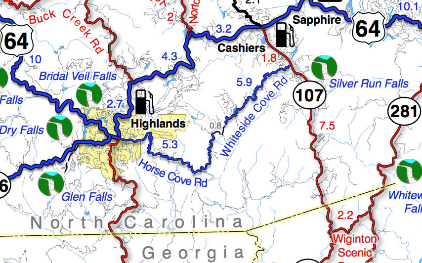
Horse Cove Road to Whiteside Cove Road has a short section that is unpaved, but it’s worth riding through on your motorcycle adventures.
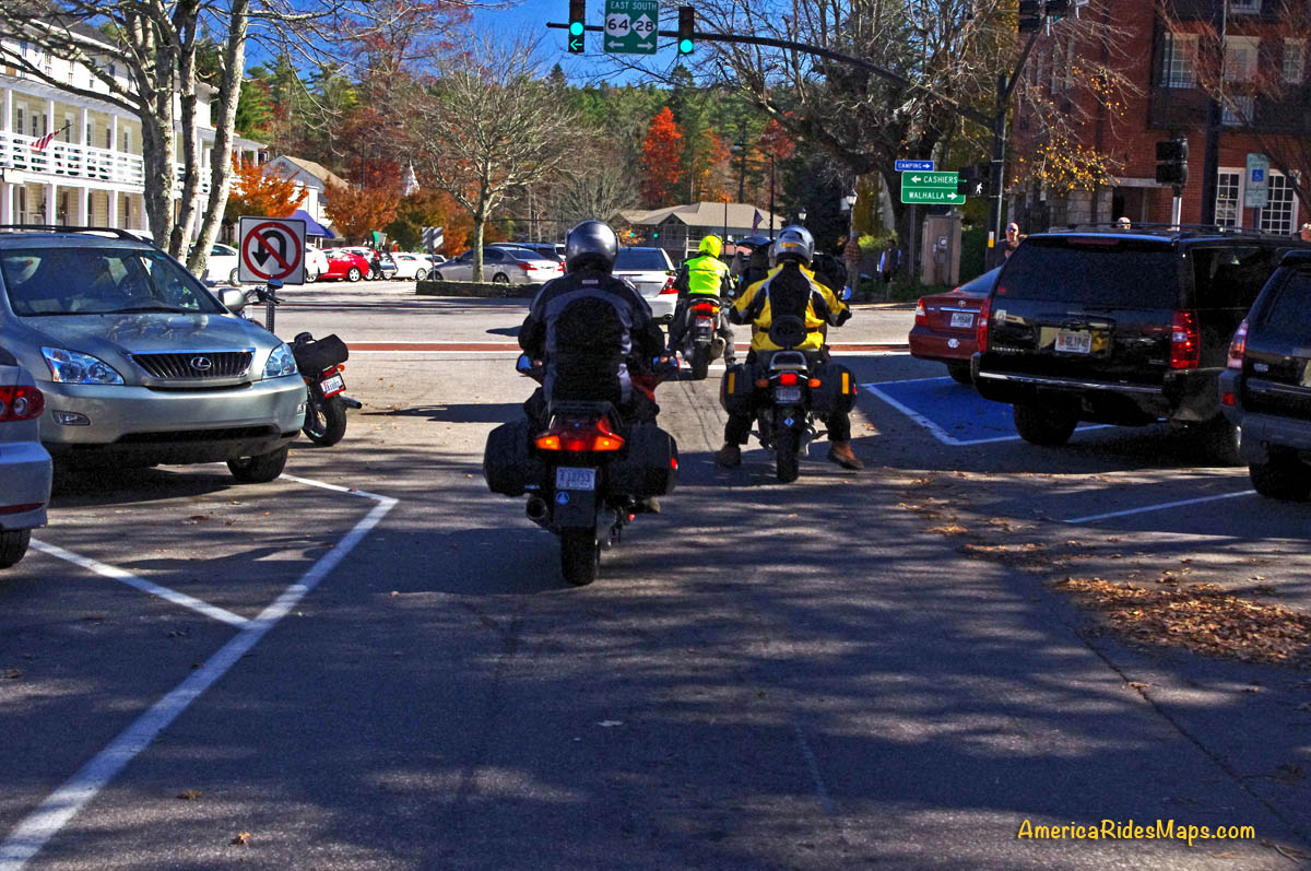
The main traffic light in Highlands, NC. Most riders make a turn. Continue straight ahead to ride Horse Cove Road.
Highlands, NC is just a few lies from the borders with Georgia and South Carolina. It’s a popular riding area with many roadside waterfalls. US 64 jogs to the north from town, NC 28 heads south. Both are great rides. If you’re up for a bit of adventure, try going straight to reach Horse Cove Road.
Horse Cove Road leads to a 0.8 mile section of graded hardback road. It then becomes Whiteside Road and intersects NC 107 south of Cashiers. The unpaved section is well maintained.
The plunge down the switchbacks on Horse Cove Road is both challenging and beautiful. It continues to twist and roll through thick forest dotted with homes. The unpaved section is smooth enough, you emerge by the lake beneath Whitesides Mountain. Whitesides Cove Road continues the romp through the woods to join NC 107 south of Cashiers.
Parked beside the frozen lake beneath the 1000 ft. cliffs of Whiteside Mountain on a winter ride.
You’ll find the best motorcycle rides in the surroundings on Map #6 and Map #7.
If you enjoy photos of motorcycle riding in the Blue Ridge and Smoky Mountains, like MY BLUE RIDGE MOTORCYCLING FACEBOOK PAGE.
____________________________________________________________________
Wayne Busch
– Wayne Busch lives in Waynesville, NC, where he produces the most detailed and comprehensive and up-to-date motorcycle pocket maps of the Blue Ridge and Smoky Mountains to help you get the most of your vacation experience. See them here – AmericaRidesMaps.com
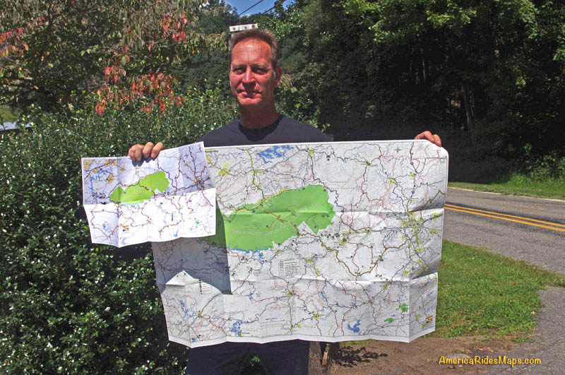
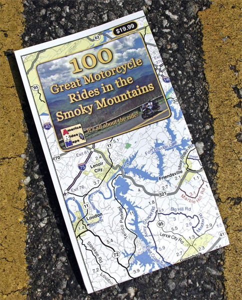
100 Great Smoky Mountain Motorcycle Rides Map – both folded (road use) and unfolded (wall display) versions. Waterproof and durable. Red Roads are best, Blue Roads are best connectors.
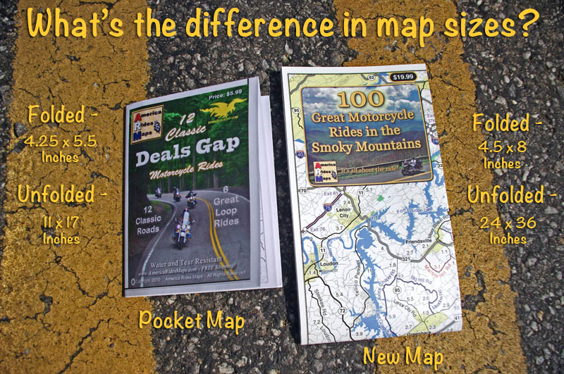
100 Great Smoky Mountain Motorcycle Rides is the “grown up” version of our most popular 12 Classic Deals Gap Motorcycle Rides pocket map. This new larger and more detailed map adds in all the great roads that are not featured on the smaller map, more than 100 of them.
Size comparison – pocket maps vs. new map unfolded. More detail, easy to read, tons more roads!
——————————————————————-
4.5 x 8 inches folded
ABOUT:
Discalimer –
There are way more then 100 great motorcycle rides on this map
Most of these roads are peripheral to the actual geologic formation of the Smoky Mountains
This new larger format map (24×36 inches) combines at least 3 pocket maps (#6, #7, #8) and sections of 2 more (#5, #9) into one larger map that encircles and includes all the best motorcycle rides surrounding Great Smoky Mountains National Park.
This map stretches from Tellico Plains, TN in the west to include the Cherohala Skyway, The Dragon, and connecting roads, to beyond Asheville, NC in the east. It dips into Georgia and South Carolina, and reaches as far north as Knoxville, TN. Within these borders lie some of the best motorcycle roads in the nation.
For the first time visitor – all the great motorcycle roads are at your disposal.
For the return visitor – expand on what you’ve already discovered
I’ve had no time to get them out to sellers so these are the few places they are available and in limited supply at that. Once I return from my motorcycle trip I’ll get more out to the other vendors.
Note –while paving is done (it was a quality job) there is still fill work along the shoulders and pavement markings / lines need to be added so expect work crews in the area. It will take a bit for the gravel at the edges of the road to settle in, so you need to be watchful for loose stone in the curves for a while.
We’ve just come in off a great North Carolina motorcycle ride on the newly paved sections of US 276 which connect Waynesville to Brevard just south of Great Smoky Mountains National Park in North Carolina. US 276 crosses the best and most scenic area of the Blue Ridge Parkway at the mid-point on this 30 mile ride.
Best North Carolina motorcycle rides – Jackie gives a big “thumbs up” to the fresh paving on US 276 near the Blue Ridge Parkway
South of the Blue Ridge Parkway, the fresh paving invites motorcycle riders to snake all the way down from the parkway’s heights to popular Looking Glass Falls, one of the most visited roadside waterfalls in the southeast. Along the way you’ll find scenic areas like Pink Beds, informative and historic places like The Cradle of Forestry, and you might even want to plunge 60 feet down a waterfall for a chilly wake-up at Sliding Rock. The entire ride carves and switchbacks through the steep and wooded mountains of the Pisgah National Forest with whitewater streams, dark tree lined passages, and numerous pull-outs to stop ad savor the surroundings.
Best motorcycle rides North Carolina – the south side of US 276 winds through thick forest
North of the Blue Ridge Parkway, US 276 drops more than 1000 feet in a 3 mile plunge from Wagon Road Gap (MP 412.2) to the trailhead at Big East Fork, then it flanks along the slopes of Cold Mountain following the Pigeon River to the Bethel Valley. This section of tight curves is one of the most sustained series of back-to-back turns you’ll come across anywhere AND it’s a steep grade to boot. For the motorcycle rider looking for a challenging stretch of road, this one has all you need!
Why is this important?
US 276 is one leg of a triangle which form a number of the best motorcycle rides in North Carolina I call The Pisgah Triangles. The other long leg of the triangle is NC 215. Several roads form third legs of a series of triangles crossing between NC 215 and US 276 within the upside down “V” formed. The roads which hold the most challenging, steep, curvy, and scenic sections of the rides are found near the top of the triangle and have been in poor repair making a challenging ride even more difficult. Once these sections of road are repaved, the quality of the motorcycle rides on The Pisgah Triangles will beat most, if not all of the best motorcycle rides in North Carolina.
Great Motorcycle Rides in North Carolina – Pisgah Triangles motorcycle map – At least 4 variations, the 3rd is my favorite.
We were delighted to see the upper portions of NC 215 are also receiving a sweet smooth coating of fresh asphalt. There is still a good bit to be done as it’s a much longer run down to the Sunburst Campground at the edge of the national forest. Like US 276, NC 215 traces the course of the Little East Fork of the Pigeon River as it rushes down from the heights.
Best Motorcycle Rides North Carolina – Paving on NC 215 has started from the top down. You can see one lane done here, still a way to go.
Easy to find, convenient to ride, lots of options!
Both US 276 and NC 215 intersect the Blue Ridge Parkway on the highest and most scenic portion of the road. If you are riding the Blue Ridge Parkway it’s easy to hop off and play with these roads or if you are riding through, it’s a short cruise to loop back from the south end at Cherokee and enjoy. I believe most riders are going to enjoy these roads more than The Dragon at Deals Gap as they are not only curvy, but wonderfully scenic and carry very light traffic.
– Wayne Busch lives in Waynesville, NC, where he produces the most detailed and comprehensive and up-to-date motorcycle pocket maps of the Blue Ridge and Smoky Mountains to help you get the most of your vacation experience. See them here – AmericaRidesMaps.com
Great Motorcycle Rides in North Carolina – The Pisgah Triangles Map
Great Motorcycle Rides in North Carolina – Pisgah Triangles motorcycle map – At least 4 variations, the 3rd is my favorite.
Great Motorcycle Rides in North Carolina – The Pisgah Triangles are some of the best motorcycle rides in the world. You’ll see spectacular views, wonderful waterfalls, and ride curves and twists that go on and on and on!
US 276 and NC 215 are two of the finest motorcycle rides you’ll find. Both roads run south from Waynesville / Maggie Valley forming a large upside-down “V”. Connections between these two long roads make 4 triangle shaped rides. Ride a short fun loop or have an all day adventure!
Complete your triangle with – The Blue Ridge Parkway, US 64, East Fork Road,
or SC 11
Great Motorcycle Rides in North Carolina – Pisgah Triangles – Looking Glass Falls on US 276 is one of the most visited roadside waterfalls in North Carolina
Roll into Waynesville or Maggie Valley and ask someone to direct you to the best and most scenic motorcycle rides and their finger will point you to the jagged southern horizon. Home to the highest and best section of the Blue Ridge Parkway, two of the roads that lead out of town and climb to the mile high mountaintops are drop-dead beautiful and filled with the curves and switchbacks that make a biker come alive.
The Pisgah Triangles is a name I use to describe this collection of great motorcycle rides in western North Carolina as so much of it is through the wilderness of the Pisgah National Forest. These are four good options for rides, though are are several others, including some excellent unpaved forest roads for you adventure bikers. There are also roads which lead out to even more fabulous riding not shown on this map.
Great Motorcycle Rides in North Carolina – Pisgah Triangles – NC 215 is the lesser known leg of the Pisgah Triangles, crossing the parkway midway. It’s a popular rest stop in the middle of the wilderness.
Any of these 3 roads – the Blue Ridge Parkway, US 276, and NC 215 are great motorcycle rides you never, ever, tire of enjoying on your motorcycle vacation trip. It’s the first place we local bikers head to as well. Here are 4 outstanding North Carolina motorcycle loop rides you can choose from to get the most out of your precious time while out motorcycle touring in the Blue Ridge.
Great Motorcycle Rides in North Carolina – Pisgah Triangles – Cradle-of-forestry is one of several stops on US 276, along with Pink Beds, Sliding Rock, Looking Glass Falls, Blue Ridge Motorcycle Campground, Jukebox Junction, …
While you could blast through the shortest loop in less than 3 hours, chances are you won’t. There are so many great views you can’t help but stop and admire them along the ride. The first of the Pisgah Triangles is the first motorcycle ride I recommend to visitors after the Blue Ridge Parkway – it’s that good.
Great Motorcycle Rides in North Carolina – Pisgah Triangles -NC 215 – Cathedral Falls is hidden just off the road, but is worth the stop as there are 4 other waterfalls with just a short walk.
The second of the loops climbs to the Blue Ridge Parkway, then down into the next valley near Brevard and Rosman. If you want to include a few roadside waterfalls in your motorcycle tour, this is the way to get in some good ones and enjoy some more great curvy sections of road. I usually avoid using US 64 through Brevard and the traffic on the 4-lane, as the 3rd loop is so much nicer.
Great Motorcycle Rides in North Carolina – Pisgah Triangles – US 276 junction with the Blue Ridge Parkway. As both NC 215 and US 276 connect, you can always hop up and take a quick break with the best of views.
The third loop is just a little tricky as you jump from backroad to backroad, but it is such a nice and scenic motorcycle ride it is worth the effort and one of my favorite motorcycle rides of all. Dodging south of US 64 gets you off the four lane and on to some great rides along trout rivers and streams. Hard not to come back smiling from this one!
Great Motorcycle Rides in North Carolina – Pisgah Triangles – The climbs up to the highest section of the Blue Ridge Parkway then down to the next valley are packed with switchbacks, curves, and twists that are so much fun to ride!
The longest loop takes you into South Carolina to the very edge of the Blue Ridge Mountains, follows a long straight section of the Foothills Scenic Highway (SC 11), then comes back into North Carolina and a wonderfully twisty ride. The plunge into South Carolina from Caesar’s Head State Park is one you’ll remember!
Great Motorcycle Rides in North Carolina – Pisgah Triangles – Chances are you’ll miss this view plunging down from Caesar’s Head State Park into South Carolina and US 276 carves through the tight switchbacks.
Shortest loop 50 miles. 3 hours, more with stops. Longest loop 120 miles – All day ride
Routes:
Loop 1 – use Blue Ridge Parkway. 50 miles, 2 -3 hours or more.
Starts in Waynesville – Leave downtown Waynesville on US 276 south to reach the top point of the Pisgah Triangles.
6.3 miContinue straight at traffic light on US 276.
20.8 miTurn left to follow ramp to the Blue Ridge Parkway at Wagon Road Gap.
20.9 miTurn left at stop sing onto the Blue Ridge Parkway (towards Cherokee).
31.9 miExit the Blue Ridge Parkway at NC 215.
40 mi Turn Left at stop sign onto NC 215 (towards Canton). NC 215 becomes Lake Logan Rd.
49.9 mi End of loop 1 in Bethel. 6.3 miles back to Waynesville on US 276.
Loop 2 – Use US 64. 90 miles, 3-5 hours
Starts in Waynesville – Leave downtown Waynesville on US 276 south
6.3 miPass through the traffic light in Bethel.
20.8 miPass under the Blue Ridge Parkway
35.3 miTurn right @ traffic light onto US 64.
47.8 mi Turn Right onto NC 215 (Parkway Road).
64.8 mi Pass under Blue Ridge Parkway
90+ mi. Follow directions for loop 1 return to Waynesville
Loop 3 – Use East Fork Rd / Wilson Rd. 100 miles, 5 -7 hours
Starts in Waynesville – Leave downtown Waynesville on US 276 south.
35.3 miTurn right @ traffic light onto US 64. Move into the left lane.
35.4 miTurn left @ traffic light onto Ecusta Rd. Follow 1.6 miles to next traffic light at Old Hendersonville Highway.
37 mi Turn right, go about 200 yards, then turn left onto Wilson Rd. Follow Wilson Rd to US 276 (Greenville Highway
40.7 miTurn left @ stop sign onto US 276 (Greenville Highway).
46.1 miTurn right onto East Fork Road.
54.6 mi Turn left to stay on East Fork Road. Watch for gray metal barn on left near this turn. Follow East Fork Road to US 178 (Pickens Highway).
58.3 miTurn right @ stop sign onto US 178 (Pickens Highway) and follow into Rosman.
59 miTurn left @ traffic light when you enter Rosman to reach US 64.
60 mi Turn left at stop sign onto US 64
60.5 miTurn right onto NC 215 (Parkway Road)
95.5 miTurn left onto US 276 in Bethel. 6.3 miles to Waynesville.
Loop 4 – Use NC 11 – (Foothills Scenic Parkway)
Follow Loop 3 directions to mile 46.1. Continue south on Greenville Highway (US 276) into South Carolina.
58.1 mi Turn right @ stop sign onto SC 11. Follow 8.9 mi.
67 miTurn right onto US 178 (Moorefield Memorial Highway). Follow 15.6 miles to Rosman.
Return to Bethel using Loop 3 directions. 120 miles.
Here’s a video that shows riding in the area:
This is it. These are the rides you should do. They have everything you come to the mountains for. This is bucket-list quality stuff. These are some of the best motorcycle rides in North Carolina. Don’t miss the Pisgah Triangles on your next trip.
– Wayne Busch lives in Waynesville, NC, where he produces the most detailed and comprehensive and up-to-date motorcycle pocket maps of the Blue Ridge and Smoky Mountains to help you get the most of your vacation experience. See them here – AmericaRidesMaps.com
Great Motorcycle Rides North Carolina – The Rattler Motorcycle Map
Great Motorcycle Rides in North Carolina - NC 209, a.k.a. "The Rattler". Do it as an out-and-back or make a nice loop ride - one of many ways to go on this great biker road
You’ve already tasted the Tail of the Dragon (if it didn’t take a bite out of you), and probably enjoyed the sweet curves of the Cherohala Skyway.
By now you realize there must be a ton of biker roads out there – “So, WHAT’S NEXT?”
Great Motorcycle Rides in North Carolina - NC 209, a.k.a. "The Rattler" - This is some of the best motorcycle riding you'll find in the world. These riders are looping back to NC 209 on NC 63.
Not one, but two motorcycle rides immediately spring to mind, so I flipped a coin. The Rattler won.
For years, this great motorcycle ride was well known amongst locals (and those in-the-know) as “209” or “Hot Springs”. It’s one of the default, always-good motorcycle rides that you can do over and over again and enjoy it every time. A few years back, it got named “The Rattler“. I don’t know who started that, but it stuck, and you can buy T-shirts along the route – I guess it’s official.
The Rattler motorcycle ride takes you on a 30+ mile jaunt through the mountains and valleys north of Maggie Valley and Waynesville to the tiny town of Hot Springs near the Tennessee border.
Great Motorcycle Rides North Carolina - The Rattler; Nice valley rides coursing along rushing streams, climbs over several mountain passes, and tight-tight twists as you approach Hot Springs
It’s a great “lunch ride” or “afternoon spin” as it only takes an hour or less to ride the twisty two lane. It’s also a “warm up” for those motorcycle touring fans who really know the area.
One you get to Hot Springs, you are surrounded with good motorcycle roads to choose from if you know where they hide.
Great Motorcycle Rides in North Carolina - NC 209 The Rattler - pastoral views of mountain farms and creeks, winding passes through forests, and some of the most challenging tarmac you'll ride wait for you in North Carolina on The Ratterl
Ride Guide – 36 miles to Hot Springs – About 1 hour ride to hot springs.
98 miles to do loop ride shown – 1/2 day ride.
Route:
Start:Exit 104 on Highway US 74. Lowes store at this exit. Pass under US 74. Follow NC 209 north.
3.7 miCross I-40 at Exit 24. It’s an easy ride through the valleys for a few miles.
11.9 mi Turn Right onto Betsy’s Creek Road to continue on NC 209. Ferguson’s store / gas marks this corner. Lots of signs.
22 mi Junction NC 63. Note and pass through. – Store and gas at this junction. Popular spot for a break, loop returns here.
36.6 mi NC 209 ends at Hot Springs. Return as you came or continue on loop ride.
To continue on loop ride –
Pass through Hot Springs. Cross the French Broad River and follow US 25 for 5 miles. US 25 will reach a stop sign.
41.7 mi Turn right @ stop sign to continue on US 25 / 70 towards Asheville.
50.9 miVeer right into Marshall on Main Street. Follow into town.
61.6 miTurn right at the traffic light in the center of Marshall and cross the bridge over the French Broad River.
You are now on Bailey Branch Rd. It will become Meadows Town Road. Meadows Town Road ends in 10 miles at NC 63.
71.5 miTurn Right @ stop sign and follow NC 63 to return to the mid point of NC 209.
85.5 miTurn left @ stop sign onto NC 209 and follow back to Junaluska to finish the ride.
98.4 mi End of ride
Here’s a 10 minute video that takes you through the ride step-by-step
– Wayne Busch lives in Waynesville, NC, where he produces the most detailed and comprehensive and up-to-date motorcycle pocket maps of the Blue Ridge and Smoky Mountains to help you get the most of your vacation experience. See them here – AmericaRidesMaps.com
The beautiful region south of Great Smoky Mountains National Park is often called “The Land of the Waterfalls” and is one of the most popular areas to ride on a motorcycle. More than 20 nice waterfalls are located close to the roadside, another 40 or so require more serious hiking than most bikers are willing or equipped to tackle.
A path leads behind Dry Falls so you can pass beneath it without getting wet.
Dry Falls is one of the most unique though it’s an easy one to miss on your motorcycle ride despite being well marked. It’s easy to miss as it’s not directly visible from the road so you’re not tempted off the wonderfully curvy section of US 64 as it snakes through the spectacular Cullasaja Gorge between Franklin and Highlands.
This section of US 64 can be a very enjoyable ride on a motorcycle, though it’s too often hampered by other traffic drawn to see the sights and wonders. On those typical days when there is a good amount on traffic on the road, it’s definitely worth the time to stop for a break and make the short walk from the parking area to admire Dry Falls.
Dry Falls got it’s name because you can walk beneath the falls without getting wet. A large cavern beneath the rock ledge at the top of the falls has a path where you can pass behind the cascade to emerge on the other side. It has the largest and best improved parking area of all the falls in the area, so it’s an easy place to stop and enjoy.
– Wayne Busch lives in Waynesville, NC, where he produces the most detailed and comprehensive and up-to-date motorcycle pocket maps of the Blue Ridge and Smoky Mountains to help you get the most of your vacation experience. See them here – AmericaRidesMaps.com
Wayne is an advanced motorcycle instructor for Total Rider Tech teaching Lee Parks Total Control Advanced Rider Courses. It’s time you looked into advanced rider training to ride more confidently and safely, it will change your mountain riding experience. It worked so well for me I became an instructor! Total Rider Tech
Here’s a nice motorcycle ride west of Franklin, NC most riders never see. It’s easy to ride right past it onUS 64 between Franklin and Hayesville.
West view from US 64 looking towards Hayesville, North Carolina.
US 64 has long been a favorite motorcycle ride as it makes a lazy climb through the mountains of the Nantahala National Forest. It’s a popular way to travel from Franklin to Murphy, or approach the great rides found just across the border in north Georgia.
Scenic US 64 is an easy motorcycle ride with gentle climbs and descents, the curves are broad and sweeping, the road wide and well maintained, and there are a couple nice overlooks.
US 64 is an easy ride, well maintained, wide and sweeping, but it can carry a good amount of traffic at times.
Near the middle of this section of US 64 you’ll find West Old Murphy Road winding into a mountain pass to the east. It’s a nice motorcycle ride that loops back to connect with US 64 closer to Franklin in 8.6 miles.
As much as I enjoy riding US 64, I don’t give it a top rating on my maps. US 64 is the primary east-west connector across the southern border of western North Carolina. Because of this, you’ll rarely have the road to yourself to enjoy. Local, commercial and tourist traffic use US 64 and chances are you’ll run in to at least a little of it.
West Old Murphy Road let’s you escape if you do get caught behind a string of slow traffic crawling up the grade. If you’re looking for something more challenging and entertaining, you’ll find it on West Old Murphy Road.
One of my favorite break spots, a small cemetery on W Old Murphy Rd.
This great motorcycle ride circles around the south side of the mountain US 64 skirts to the north. It’s devilishly twisty in places, the pavement is decent, and there are a few nice views though it’s another one of those roads you’ll be watching the twisty pavement more than the pretty scenery.
West Old Murphy Road is easy to find at either end. Nearest Franklin, it’s near the point US 64 goes from two lanes to the four lane section which circles south of the town. Near the mid point of US 64 look for signage on the east side of the road for Standing Indian campground in the National Forest.
Not far in from the mid point is one of my favorite spots for a quick break. You’ll see a pull-off near a small embankment. Atop the rise is an old graveyard. There are some good places to sit and enjoy the reverent solitude.
You can see W Old Murphy Road is a twisty little bugger, but a lot of fun to ride.
– Wayne Busch lives in Waynesville, NC, where he produces the most detailed and comprehensive and up-to-date motorcycle pocket maps of the Blue Ridge and Smoky Mountains to help you get the most of your vacation experience. See them here – AmericaRidesMaps.com
Wayne is an advanced motorcycle instructor for Total Rider Tech teaching Lee Parks Total Control Advanced Rider Courses. It’s time you looked into advanced rider training to ride more confidently and safely, it will change your mountain riding experience. It worked so well for me I became an instructor! Total Rider Tech
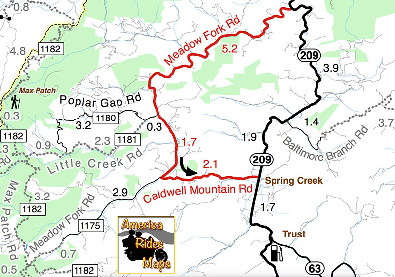
Two good motorcycle roads are found along NC 209, a.k.a. “The Rattler“. They make a nice side loop on the popular motorcycle ride from Junaluska to Hot Springs in North Carolina.
A section of Meadow Fork Road which demonstrates the character of the curves through much of the ride.
Meadow Fork Road spurs off NC 209 about 7 miles south of Hot Springs. The road follows the twisty banks of a whitewater creek for quite a while climbing gently on the challenging and scenic run. It leads into the Pisgah National Forest where it becomes one of many unpaved forest roads high in the mountains.
The 1.7 mile section of NC 209 which crosses the Spring Creek valley is the straightest road I can think of in western North Carolina. View approaching Caldwell Mountain Road
Caldwell Mountain Road meets Meadow Fork Road in 6.9 miles. 2.1 mile long Caldwell Mountain Road will take you over the mountain and down to meet NC 209 near the middle of the long straight stretch across the Spring Creek Valley.
Caldwell Mountain Rd is easy to find. Ride to the middle of the long straight stretch of NC 209 in Spring Creek. Look for the sign for Meadow Fork Campground.
Caldwell Mountain Road and Meadow Fork Road form a nice loop on the west side of NC 209 when joined together. It’s a good way to vary the ride to and from Hot Springs and see a few different sights.
The sign may be a little crooked, but so is Caldwell Mountain Rd .
Both Meadow Fork and Caldwell Mountains Roads are paved, though if you miss turning at their junction you will run out of pavement before long when Meadow Fork Road reaches the National Forest. If you are on a dual-sport or adventure bike, this is one way to access the great unpaved roads that lead up to Max Patch bald and wind into Tennessee and the eastern edge of Great Smoky Mountains National Park. (See map OR-1)
One of the few long range views on Caldwell Mountain Rd. You’ll probably be looking at the road instead.
Both of these roads are easy to find from NC 209. Their junctions are well marked. There is a prominent sign for the Meadow Fork Campground which marks the junction and it’s easy to spot Caldwell Mountain Road cutting across the felids in the valley as you approach.
Never far from the edge of the roaring creek, Meadow Fork Road twists through steep rocky hill sides and small valleys and coves.
Caldwell Mountain Road has some nice curves on the climbs and a few brief long range views. The pavement is a little bumpy in places, but generally is pretty good overall.
There are some very pleasant views along Meadow Fork Road and lots of places to pause and enjoy it.
Meadow Fork Road follows the Roaring Fork River from NC 209 as it carves through the mountains for 7 miles to reach the junction with Caldwell Mountain Road. The road traces the bank of the river making it a nice curvy motorcycle ride for the most part. The pavement is in good shape – a long section near the river washed out and was replaced a few years ago with nice new pavement.
The junction of Meadow Fork Rd and NC 209 is easy to spot though it may come up on you quickly as you come around a curve on either side.
Neither road has scenery you’ll be framing on the wall, though in general it’s pretty nice with small remote and isolated coves and valleys, the whitewater river along the road, and lots of hundred year old barns and the like.
Just a peek down Meadow Fork Road shows what lies ahead.
This side loop off NC 209 adds a nice diversion, a little something different, without adding a significant amount of time to the longer motorcycle ride on classic NC 209 – The Rattler.
The junction of Meadow Fork Rd and Caldwell Mountain Rd is easy to spot, so navigation of this ride is easy and you can focus on enjoying the roads.
– Wayne Busch lives in Waynesville, NC, where he produces the most detailed and comprehensive and up-to-date motorcycle pocket maps of the Blue Ridge and Smoky Mountains to help you get the most of your vacation experience. See them here – AmericaRidesMaps.com
Wayne is an advanced motorcycle instructor for Total Rider Tech teaching Lee Parks Total Control Advanced Rider Courses. It’s time you looked into advanced rider training to ride more confidently and safely, it will change your mountain riding experience. It worked so well for me I became an instructor! Total Rider Tech
America Rides Maps announces its first large format motorcycle ride map. Available in 24 x 36 inch and 31 x 48 sizes.
Image of map the Best Motorcycle Rides in the Smoky Mountains - B&W version. Click for a closer look at all the detail!
The only map of its kind, The Best Motorcycle Rides in the Smoky Mountains highlights more than 100 of the best motorcycle rides and more than 50 good connecting roads to tie them all together into endless loops and touring routes.
This map is produced in Black & White so YOU CAN CUSTOMIZE IT to fit your needs. Use colored markers to highlight where you’ve been or lay out where you want to go.
Planing your motorcycle vacation trip has never been easier!
Hang it on the wall to show all the places you’ve been on your motorcycle vacation tours.
Got a favorite place to stay in the Smokies? Discover all the hidden riding nearby. Make the best use of your riding time, ride on on all the best roads, avoid traffic and congestion.
$24.99 price includes free shipping and handling – First Class US Mail – average 2-3 day delivery. Ships unfolded.
– Wayne Busch lives in Waynesville, NC, where he produces the most detailed and comprehensive and up-to-date motorcycle pocket maps of the Blue Ridge and Smoky Mountains to help you get the most of your vacation experience. See them here – AmericaRidesMaps.com
Wow! It’s taken me 18 months to completely revise and update all my Smoky Mountain / Blue Ridge motorcycle ride maps, but the last of them is done – Map #9 “The Best Rides in the North Georgia Mountains” has been released.
Roads are really bold, map is easy to and quick to read. Road descriptions on back of map.
If you have one of my Georgia motorcycle maps you honestly don’t need to replace the map you have. I had almost all of the really outstanding Georgia motorcycle rides on the earlier version. I did find a couple more really nice north Georgia motorcycle rides on the periphery of the main area of the map as you make your way to the classic rides – you’ve got to ride GA 60, Blood Mountain area, and I love to play back and forth across the North Carolina state line.
Map #9 - The Best Rides in the North Georgia Mountains
So what’s the big deal? The reason this revision took so long was prepare the maps for digital use! I’ve looked at phone apps but decided the limiting factor in the mountains is reception. Live GPS positioning via phone just isn’t there yet for this region.
A solution I’ve been testing instead is map downloads which can be scaled and used from an ipad, ipod, iphone, or any other smart phone provided you’ve got a decent sized memory card. Got your phone? You’ve got your maps. It worked well on the ipad. I’ll be testing ipod, iphone, etc. next. If it goes well, you can expect to see them available in about 2-3 weeks.
So what about GPS? Next project. I have the software. I need the time.
– Wayne Busch lives in Waynesville, NC, where he produces the most detailed and comprehensive and up-to-date motorcycle pocket maps of the Blue Ridge and Smoky Mountains to help you get the most of your vacation experience. See them here – AmericaRidesMaps.com