A Good Motorcycle Ride – The Road to Nowhere

Road to Nowhere Motorcycle RideA scenic motorcycle ride on an abandoned road in Great Smoky Mountains National Park.

Road to Nowhere Motorcycle Ride Map

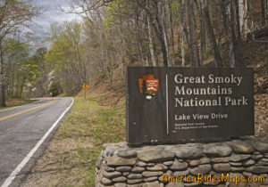
Lake View Drive in Great Smoky Mountains National Park was planned to arc around the north shore of Fontana Lake to connect to the southern lake loop road (NC 28) at the Fontana Dam. The project was abandoned about half way through and has come to be known as “The Road to Nowhere”.

Road to Nowhere Motorcycle RideThe road starts in Bryson City, NC as Everett Street. This is a great motorcycle ride to add to your lunch plans, a nice little side trip. There are a lot of good places to eat in Bryson City. One of them, The Cork and Bean, sits at the corner of this route (Everett St. / Main St.) in town.

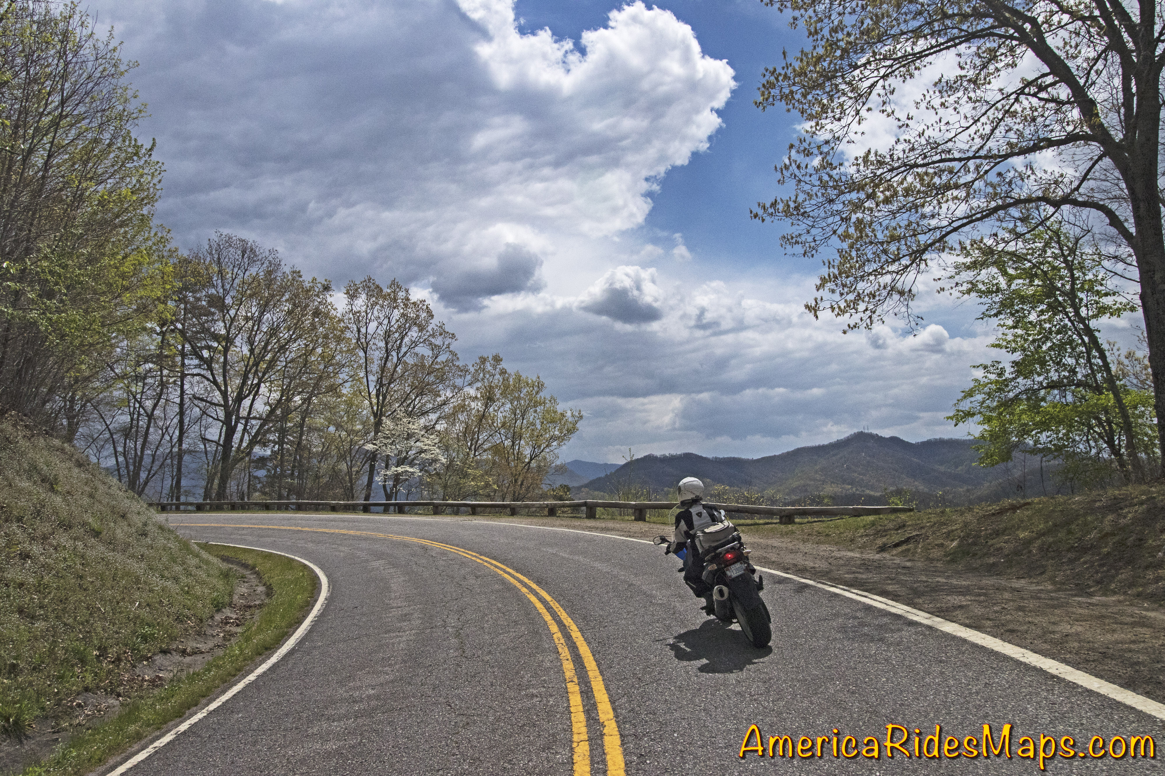
The road climbs gently from town arcing to the west as Fontana Road. Its a section of gentle flowing curves.

Road to Nowhere Motorcycle Ride
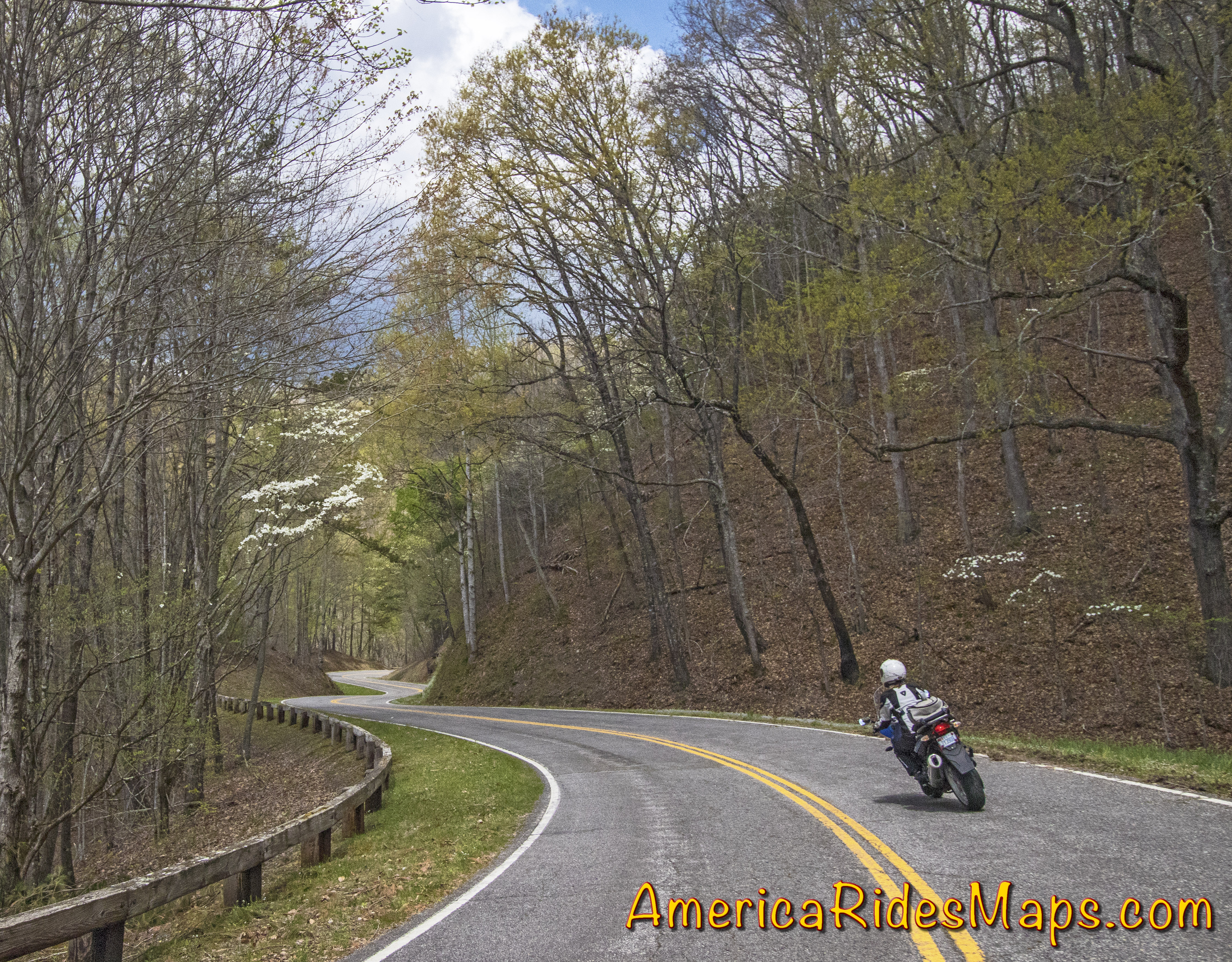
There is a sign at the park border. The road gets much tighter and from here on with curve after curve the whole way.

There are a few spots to pull off and get views of the lake.

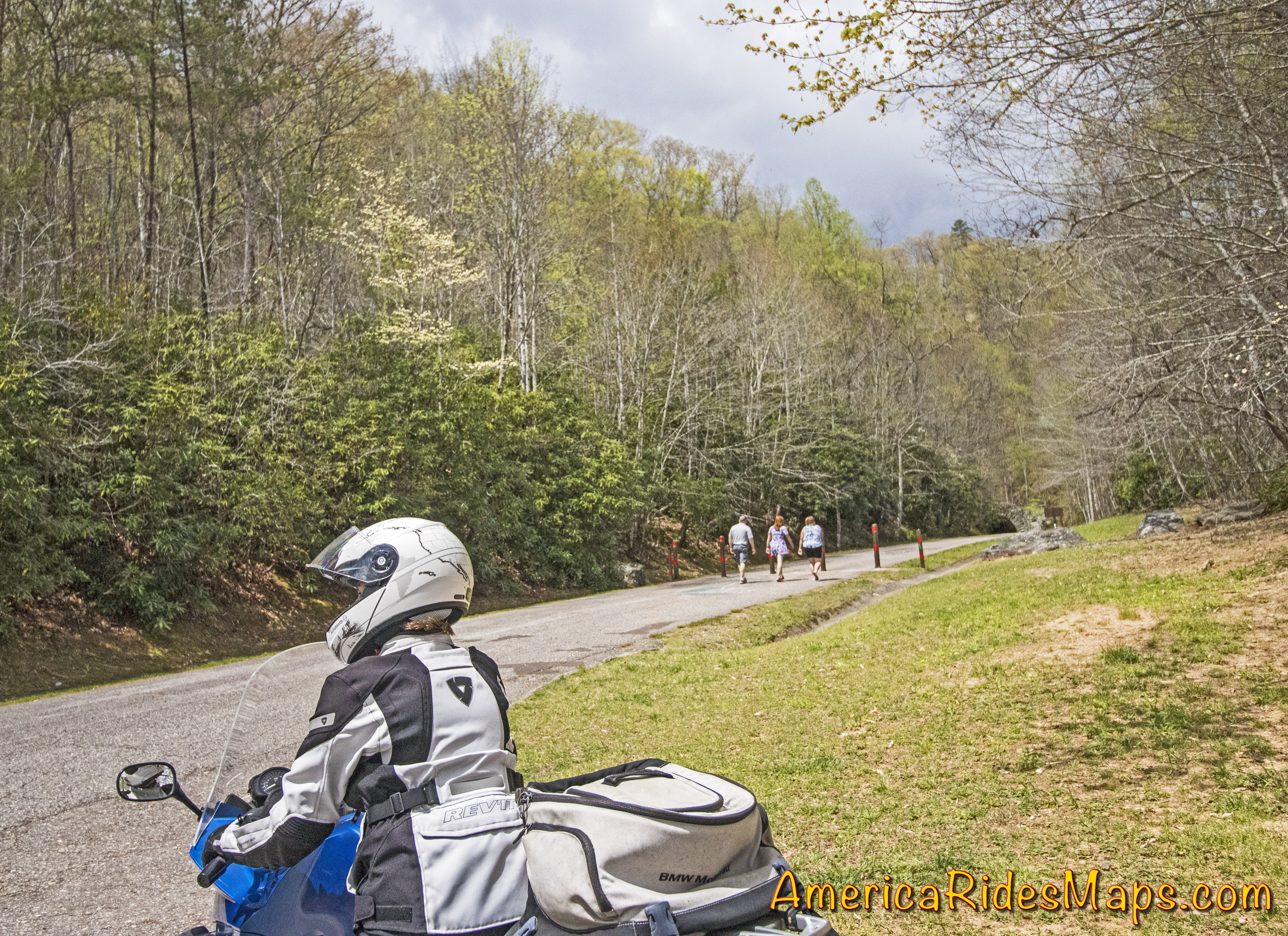
The road ends at a paved parking loop. A series of brown slats barricade the road beyond.  You can just see the stone arch tunnel where the road ends from the turn-around. Hiking only once through the tunnel.

Road to Nowhere end Motorcycle RideThere are many stories and controversies over this road. Some see it as a boondoggle. The government has yet to compensate for the land. A family cemetery was isolated, the park service periodically ferries them by boat. Regardless, the result is a really curvy ride with some nice views we can enjoy.

It’s 8.5 miles from town to the end of the road, so you can make it a quick out-and-back ride or stop to savor the views and the wildlife. There are other nice roads nearby if you enjoy exploring the more adventurous back roads including some good unpaved roads.

Road to Nowhere Motorcycle RideYou’ll find this road on map #7,Map #8, Map 100 Great Motorcycle Rides in the Smoky Mountains, and others from America Rides Maps. There are more great motorcycle roads in the Blue Ridge Mountains than anywhere else – find them here;

AmericaRidesMaps.com


Wayne BuschAmerica Rides Maps

Wayne Busch searches out the most entertaining roads in the Blue Ridge Mountains then records them on a series of maps which span the Blue Ridge Mountains.

There are more great motorcycle roads in the Blue Ridge and Smoky Mountains than anywhere else. I highlight the best roads then show you the best ways to connect them together into rides. More than a decade of searching has discovered more than 1000 good roads to enjoy. We continue to search so you may enjoy.

Review the maps, order online hereAmericaRidesMaps.com

Best Motorcycle Rides North Carolina – Pisgah Triangles Repaved!

Fresh paving bumps this NC motorcycle ride to the top of list!

Freshly paved  –

  • US 276 from Fish Hatchery Road to the Blue Ridge Parkway (done)
  • US 276 from the Blue Ridge Parkway to Big East Fork (done)
  • NC 215 from Blue Ridge Parkway to Sunburst (in progress)

Unbelievable! Fantastic! Outstanding motorcycle ride!

US 276 – the Newly Paved Section

Note – while paving is done (it was a quality job) there is still fill work along the shoulders and pavement markings / lines need to be added so expect work crews in the area. It will take a bit for the gravel at the edges of the road to settle in, so you need to be watchful for loose stone in the curves for a while. 

We’ve just come in off a great North Carolina motorcycle ride on the newly paved sections of US 276 which connect Waynesville to Brevard just south of Great Smoky Mountains National Park in North Carolina. US 276 crosses the best and most scenic area of the Blue Ridge Parkway at the mid-point on this 30 mile ride.

Best North Carolina motorcycle rides - US 276

Best North Carolina motorcycle rides – Jackie gives a big “thumbs up” to the fresh paving on US 276 near the Blue Ridge Parkway

South of the Blue Ridge Parkway, the fresh paving invites motorcycle riders to snake all the way down from the parkway’s heights to popular Looking Glass Falls, one of the most visited roadside waterfalls in the southeast. Along the way you’ll find scenic areas like Pink Beds, informative and historic places like The Cradle of Forestry, and you might even want to plunge 60 feet down a waterfall for a chilly wake-up at Sliding Rock. The entire ride carves and switchbacks through the steep and wooded mountains of the Pisgah National Forest with whitewater streams, dark tree lined passages, and numerous pull-outs to stop ad savor the surroundings.

Best motorcycle rides North Carolina - US 276

Best motorcycle rides North Carolina – the south side of US 276 winds through thick forest

North of the Blue Ridge Parkway, US 276 drops more than 1000 feet in a 3 mile plunge from Wagon Road Gap (MP 412.2) to the trailhead at Big East Fork, then it flanks along the slopes of Cold Mountain following the Pigeon River to the Bethel Valley. This section of tight curves is one of the most sustained series of back-to-back turns you’ll come across anywhere AND it’s a steep grade to boot. For the motorcycle rider looking for a challenging stretch of road, this one has all you need!

Why is this important?

US 276 is one leg of a triangle which form a number of the best motorcycle rides in North Carolina I call The Pisgah Triangles. The other long leg of the triangle is NC 215. Several roads form third legs of a series of triangles crossing between NC 215 and US 276  within the upside down “V” formed. The roads which hold the most challenging, steep, curvy, and scenic sections of the rides are found near the top of the triangle and have been in poor repair making a challenging ride even more difficult. Once these sections of road are repaved, the quality of the motorcycle rides on The Pisgah Triangles will beat most, if not all of the best motorcycle rides in North Carolina.

Great Motorcycle Rides in North Carolina - Pisgah Triangles motorcycle map

Great Motorcycle Rides in North Carolina – Pisgah Triangles motorcycle map – At least 4 variations, the 3rd is my favorite.

See photos, map, and ride guide here – The Pisgah Triangles

The Final Piece is in the Works! – 

We were delighted to see the upper portions of NC 215 are also receiving a sweet smooth coating of fresh asphalt. There is still a good bit to be done as it’s a much longer run down to the Sunburst Campground at the edge of the national forest. Like US 276, NC 215 traces the course of the Little East Fork of the Pigeon River as it rushes down from the heights.

Best Motorcycle Rides North Carolina - NC 215

Best Motorcycle Rides North Carolina – Paving on NC 215 has started from the top down. You can see one lane done here, still a way to go.

Easy to find, convenient to ride, lots of options!

Both US 276 and NC 215 intersect the Blue Ridge Parkway on the highest and most scenic portion of the road. If you are riding the Blue Ridge Parkway it’s easy to hop off and play with these roads or if you are riding through, it’s a short cruise to loop back from the south end at Cherokee and enjoy. I believe most riders are going to enjoy these roads more than The Dragon at Deals Gap as they are not only curvy, but wonderfully scenic and carry very light traffic.

image-motorcycle-ride-map-cover

You’ll find these roads on America Rides Maps motorcycle pocket map #6 – The Best Motorcycle Rides EAST of Great Smoky Mountains National Park along with another 50 or so outstanding rides in the surrounding area and a guide to the numerous roadside waterfalls.

____________________________________________________________________

wayne busch - Smoky Mountain Motorcycle Rider.com

Wayne Busch

– Wayne Busch lives in Waynesville, NC, where he produces the most detailed and comprehensive and up-to-date motorcycle pocket maps of the Blue Ridge and Smoky Mountains to help you get the most of your vacation experience. See them here – AmericaRidesMaps.com

Total Rider Tech Logo

Learn Total Control

Wayne is an advanced motorcycle instructor for Total Rider Tech teaching Lee Parks Total Control Advanced Rider Courses. Isn’t it time you looked into advanced rider training to ride more confidently and safely? It can transform your mountain riding experience.  Total Rider Tech

____________________________________________________________________

A Great North Carolina Motorcycle Ride near Franklin

Here’s a nice motorcycle ride west of Franklin, NC most riders never see. It’s easy to ride right past it onUS 64 between Franklin and Hayesville.

photo-view-west-from-us-64

West view from US 64 looking towards Hayesville, North Carolina.

US 64 has long been a favorite motorcycle ride as it makes a lazy climb through the mountains of the Nantahala National Forest. It’s a popular way to travel from Franklin to Murphy, or approach the great rides found just across the border in north Georgia.

Scenic US 64 is an easy motorcycle ride with gentle climbs and descents, the curves are broad and sweeping, the road wide and well maintained, and there are a couple nice overlooks.

photo-fall-view-us-64

US 64 is an easy ride, well maintained, wide and sweeping, but it can carry a good amount of traffic at times.


Near the middle of this section of US 64 you’ll find West Old Murphy Road winding into a mountain pass to the east. It’s a nice motorcycle ride that loops back to connect with US 64 closer to Franklin in 8.6 miles.

As much as I enjoy riding US 64, I don’t give it a top rating on my maps. US 64 is the primary east-west connector across the southern border of western North Carolina. Because of this, you’ll rarely have the road to yourself to enjoy. Local, commercial and tourist traffic use US 64 and chances are you’ll run in to at least a little of it.

West Old Murphy Road let’s you escape if you do get caught behind a string of slow traffic crawling up the grade.  If you’re looking for something more challenging and entertaining, you’ll find it on West Old Murphy Road.

photo-cemetary-w-old-murphy-rd

One of my favorite break spots, a small cemetery on W Old Murphy Rd.

This great motorcycle ride circles around the south side of the mountain US 64 skirts to the north. It’s devilishly twisty in places, the pavement is decent, and there are a few nice views though it’s another one of those roads you’ll be watching the  twisty pavement more than the pretty scenery.

West Old Murphy Road is easy to find at either end. Nearest Franklin, it’s near the point US 64 goes from two lanes to the four lane section  which circles south of the town. Near the mid point of US 64 look for signage on the east side of the road for Standing Indian campground in the National Forest.

Not far in from the mid point is one of my favorite spots for a quick break. You’ll see a pull-off near a small embankment. Atop the rise is an old graveyard. There are some good places to sit and enjoy the reverent solitude.

image-map-of-w-old-murphy-rd

You can see W Old Murphy Road is a twisty little bugger, but a lot of fun to ride.

_______________________________________________________________________________

Wayne Busch

Wayne Busch – Cartographer

Total Rider Tech Logo

Learn Total Control

– Wayne Busch lives in Waynesville, NC, where he produces the most detailed and comprehensive and up-to-date motorcycle pocket maps of the Blue Ridge and Smoky Mountains to help you get the most of your vacation experience. See them here – AmericaRidesMaps.com

Wayne is an advanced motorcycle instructor for Total Rider Tech teaching Lee Parks Total Control Advanced Rider Courses. It’s time you looked into advanced rider training to ride more confidently and safely, it will change your mountain riding experience. It worked so well for me I became an instructor! Total Rider Tech

_______________________________________________________________________________

West Old Murphy Road and many other roads in the surrounding area is found on America Rides Maps #7 – The Best Motorcycle Rides SOUTH of GSMNP
The start of it is also shown on America Rides Maps  – Map #9 – The Best Rides in the North Georgia Mountains


Not Good Enough for 100 Smoky Mountain Motorcycle Rides

I’ve just released a map of the Smoky Mountains which shows nearly 200 motorcycle rides highlighted on it. Here’s one that won’t be on it, not good enough.

Photo-Grapevine-rd

A long section of bad pavement gives way to some great curves.

Yesterday, Jackie and I hopped on the bikes to follow up on a rumor of yet another good motorcycle ride tucked away in the mountains. Possibilities were high as the area northeast of Hot Springs, NC, is ripe with some of the most challenging and technical motorcycle rides you’ll find anywhere. The two lane roads that wind through these Tennessee mountains hug the edges of rushing creeks which snake the bottoms of shady valleys or carve steep steps through gaps and passes.

This is no place for the faint of heart nor the inexperienced motorcycle rider, though by the time you reach it those riders who won’t accept the challenge have already turned tail and run. Roads like NC 209, NC 208 probably give most riders as much thrill as they want. Only the adventurous consider these approaching roads just a warm-up and look to kick the ride up a notch with more challenging pavement.

photo-grapevine-rd

There are some very nice sections of Grapevine Rd, but overall, NOT GOOD ENOUGH!

I remembered Grapevine Road as soon as I turned on it. I’d been told by a couple people they thought it was a great motorcycle ride, but for some reason I couldn’t remember I’d not put it on one of my maps. I quickly figured out why.

The pavement was in such bad shape. Broken and potholed, sunken, bumpy, strewn with gravel, rocks, and loose asphalt. Add to that steep grades, devilish tight switchbacks, unforgiving drop-offs, and you’ve got a real handful, especially on a big bike.

The reason I’d come back to Grapevine Road is the last time, I made a quick judgment and turned around. Not having gone all the way through, I didn’t know how far until the pavement improved. I knew it had to get better as it approached more civilized areas to the south.

photo-jackie-thumbs-down

Jackie votes "thumbs down" on Grapevine Rd.

It was a long ride until the pavement smoothed out. Once it did, there was a decent section with some nice curves which become more sweeping and open, but little of scenic appeal.

Some may like this road, but there are so many better ones nearby, it’s the least appealing. Jackie gave it the “thumbs down”. No reason to recommend Grapevine Road.

_______________________________________________________________________________

Wayne Busch

Wayne Busch - Cartographer

Total Rider Tech Logo

Learn Total Control

– Wayne Busch lives in Waynesville, NC, where he produces the most detailed and comprehensive and up-to-date motorcycle pocket maps of the Blue Ridge and Smoky Mountains to help you get the most of your vacation experience. See them here – AmericaRidesMaps.com

Wayne is an advanced motorcycle instructor for Total Rider Tech teaching Lee Parks Total Control Advanced Rider Courses. It’s time you looked into advanced rider training to ride more confidently and safely, it will change your mountain riding experience. It worked so well for me I became an instructor! Total Rider Tech

_______________________________________________________________________________

See the map “Best Motorcycle Rides of the Smoky Mountains

Video – The Diamondback Motorcycle Ride Near the Blue Ridge Parkway

http://www.youtube.com/watch?v=wmUlsQzX-fw

Ride along with Jackie (from America Rides Maps)  as she careens down the Diamondback Motorcycle Route. Accessed from the Blue Ridge Parkway, this is one of those side roads you should add to your motorcycle vacation plan. The Diamondback is one of the big three motorcycle rides in North Carolina, joining the Snake and the Dragon in the pantheon of classic and challenging rides. Included are scenes from the Switzerland Inn, one of the top motorcycle friendly destinations on the Blue Ridge Parkway.

You can find videos of other great Smoky Mountain motorcycle rides, video tips, and more at America Rides Maps YouTube channel – http://www.youtube.com/user/americaridesmaps

_______________________________________________________________________________

Wayne Busch

Wayne Busch - Cartographer


– Wayne Busch lives in Waynesville, NC, where he produces the most detailed and comprehensive and up-to-date motorcycle pocket maps of the Blue Ridge and Smoky Mountains to help you get the most of your vacation experience. See them here – AmericaRidesMaps.com


Great New Motorcycle Route Named In North Carolina

The practice of naming great motorcycle rides is a long and honored tradition. It’s a convenient shorthand way to refer to a road or series of roads that makes for a particularly good motorcycle ride. The Dragon, Hellbender 28, Blood Mountain, The Devil’s Triangle, Thunder Road, and many others are all utilized to describe rides that rise to the level of classic motorcycle rides. Add one more to the list – the Diamondback (NC 226A) and the Lake James Route.

Image - The Diamondback Post Card Map

Postcard image of the Diamondback / Lake James Route which originates at the Switzerland Inn

This 65 mile loop combines a number of great sections of road into one beautiful and entertaining ride which offers a great combination of outstanding mountain scenery and challenging curvy two lane roads. The ride originates at the luxurious Switzerland Inn adjacent to the Blue Ridge Parkway in Little Switzerland. Located on sinuous 226A, the ride can be enjoyed in either direction though I’m inclined to immediately jump down the steep and technical descent from the Inn and get the party started. On the return via the Blue Ridge Parkway I’ll savor my fun and let the bike cool down after the hot sections along the route.

Photo - View of the grounds at the Switzerland Inn

The Switzerland Inn – A beautiful Resort on the Blue Ridge Parkway

After the initial descent, NC 226 gives you a chance to catch your breath before you turn northeast to trace the foothills and the twisty ride to reach NC 181.  Turn back towards the high country, I most enjoy NC 181 when climbing. The sweeping turns and curves have long been a favorite ride for motorcyclists in the area and you’ll get the best views of dramatic Table Rock while clawing your way up the mountainside. While beautiful and entertaining, the Blue Ridge Parkway section returning to the inn is a nice cherry on top of the shake below.

Photo - Table Rock

Table Rock is even more dramatic as it imposes on the horizon viewed end on from NC 181

I’m shipping post card maps of this ride with every order America Rides Maps so long as they last to help you discover this great loop ride. For those motorcycle touring along the Blue Ridge Parkway, the Diamondback makes for a wonderful side trip to add to your motorcycle adventures.

You’ll find these great roads and many, many more on America Rides Maps “The Best Roads North and South of Asheville, NC” . Contact the Switzerland Inn for even more detail and be sure to visit http://diamondbacknc.com .


Wayne Busch - AMERICA RIDES MAPS

Wayne Busch – AMERICA RIDES MAPS

America Rides Maps

Why Is Riding the Tail of the Dragon at Deals Gap So Dangerous?

Photo - Smoky Mountain Rider and BMW Girl at the Tail of the Dragon

Smoky Mountain Rider and BMW Girl at the Tail of the Dragon

If you’re convinced the Tail of the Dragon at Deals Gap in North Carolina is “too dangerous” or “ too challenging” a motorcycle ride, you’ve been deluded. If you can negotiate a crowded parking lot without panic, navigate city traffic, or confidently explore unknown back roads, you can ride the “infamous” stretch of US 129 at known as “The Tail of the Dragon”.

While riders are killed on the Dragons Tail almost every year (once you visit you’ll know why) it’s not the road that does them in. It’s a great motorcycle road with more than 300 curves in 11 miles. The pavement is nice, the road is well engineered, and it sees little commercial traffic. Still the motorcycle accidents at Deals Gap keep piling up.

Truth is, motorcycle riders crash here due to their own expectations. The Tail of the Dragon near Deals Gap is so hyped as a challenging and dangerous motorcycle ride people believe they have to make it one. Too many bikers push their limits on this great ride to fulfill the myth and prove something to themselves. Those limits of skill and reason are exceeded far too often resulting in motorcycle wrecks that would not have otherwise occurred had the rider not been so persuaded this was the ideal place to test his mettle. Truth is, I can direct you to roads far more dangerous, all of which make for good motorcycle rides you will enjoy and savor if you don’t consciously try to kill yourself.

That said, the Tail of the Dragon may not be for everyone. If your bike was on the showroom floor last week, and your warm license stills smells like fresh plastic, think twice, break in the tires and get a few miles beneath them. The Blue Ridge Parkway will give you all you need, and I’ve mapped hundreds of miles of other great motorcycle roads in the area.

There are certainly TIMES to avoid the Tail of the Dragon. A rally can turn it into a suicidal circus. Weekends bring out the squids and posers. Safest bet is to go mid week, early in the day. Be warned, it’s heavily patrolled by overworked troopers who have absolutely no sense of humor left.

With hundreds of posted videos to choose from, you can be sure I’ll be posting more. Here’s one of the longer ones that not only shows the entire ride, but demonstrates why this good motorcycle ride has earned such a bad reputation. Is it the really roads fault?

For lots more info about the Tail of the Dragon at Deals Gap visit http://tailofthedragon.com