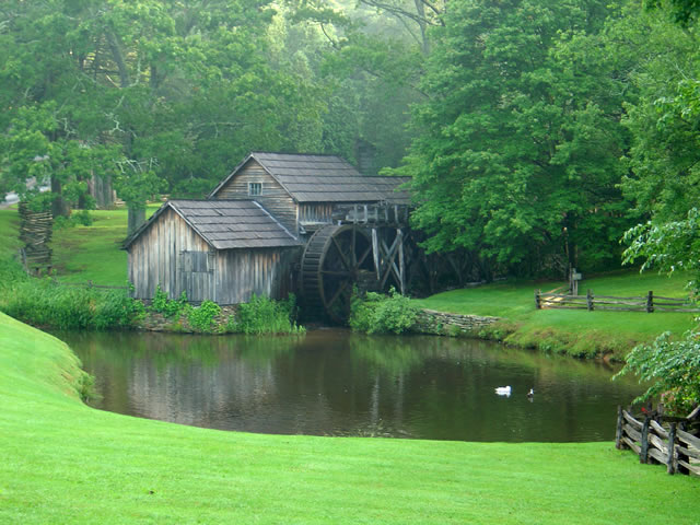
Motorcycle the Blue Ridge Parkway – Sights from the Road – Mabry Mill

Photo - Mabry Mill on the Blue Ridge Parkway

Mabry Mill – One of the most photographed sights on the Blue Ridge Parkway

One of the most popular and photographed sights on the Blue Ridge Parkway is Mabry Mill. It’s located at milepost 176 in Virginia near Meadows of Dan. Whether you’re motorcycle touring or just cruising along in your car, it’s hard to resist pulling in for a photo and a closer look (and maybe a pancake).

The mill is one of the buildings the National Park Service felt represented the character they wished to portray in their interpretation of Appalachian life and culture. It started as a blacksmith shop, then became a sawmill, then evolved into a grist mill, though it included a lathe, a planer and a jig saw so the versatile Mr. Mabry could maximize it’s use and success.

The mill has been restored and maintained and is still used for occasional demonstrations of it’s workings. The stone ground cornmeal, buckwheat flour, and grits can be enjoyed at the nearby restaurant as pancakes, biscuits, and cakes, along with preserves and country ham from the surrounding area (plan a breakfast here, but come early).

Contrary to what the Park Service originally portrayed about the “isolation and remoteness “ of these “mountain people”, there were thriving communities surrounding the area – a mill does not last long in the middle of nothing. The area surrounding the Blue Ridge Parkway in this section of southern Virginia is laced with an amazing number of fabulous two lane motorcycle rides through historic and scenic countryside. Don’t be afraid to get off the parkway on your motorcycle and enjoy some of these great motorcycle rides.


Wayne Busch - AMERICA RIDES MAPS

Wayne Busch – AMERICA RIDES MAPS

America Rides Maps

Planning Your Motorcycle Vacation Trip – What Will The Weather Be Like?

Photo - Rain clouds swirl over Waynesville, North Carolina

Rain clouds swirl over Waynesville, North Carolina

The weather on your motorcycle vacation trip will probably be better than you think or what the weatherman says, – or not. I swear that guy drinks. I know I would be hitting the old mason jar if I had his job. Predicting the weather in the Smoky Mountains is tough. Sometimes, there’s little question about taking that great ride. When there’s a massive front coming through or some system stalls for a while, you can pretty much go with what’s obvious.

In the Smoky Mountains each little valley has its own weather. It can pour down rain all day in one spot, ride your motorcycle over the hill, and the sun is shining. If I had a dollar for every time they’ve predicted rain and I’ve spent a dry day riding the great roads…

My advice – if there’s any question, get on the bike and go for it and always have some rain gear and a warm jacket or fleece in the bags. The highest elevations, like the Blue Ridge Parkway, see the most intense weather. If something’s going to happen it’s going to happen up high first. Coming down, or staying low when planning your motorcycle rides on the iffy days will often do the trick.

Weather also stalls when it hits the mountains and can’t quite make the climb over them. Try heading in the opposite direction and you can often avoid it. Bottom line, when planning your motorcycle vacation, be ready for anything.

Useful Web Resource:

One of the best resources for weather in North Carolina is Ray’s Weather site -http://www.raysweather.com/

The Most Dangerous Road for Motorcycles?

Charlies Creek Road

Charlies Creek Road - even the sign is crooked


“That’s the most dangerous road we ride” my wife commented after a recent morning outing.

It’s my favorite road!”, I responded.

“I know, but it’s still dangerous” she reiterated.

We talked a bit more about it and the things she finds most dangerous are the things I enjoy as an added challenge.

“I still like it, it’s just a dangerous road” says Jackie.

Jackie’s no lightweight. We rode dual-purpose bikes all over the country years ago, she can throw a motorcycle around. Now, astride her Beemer, she often gives the boys a run for their money on the twisty roads. She can handle herself and I enjoy watching her flow through the curves. And no, we’re not talking about the infamous “Tail of the Dragon“. That’s just another ride for us compared to this.

riding Charlies Creek Road

Be ready to get some lean on when riding Charlies Creek Road

Photo – Wayne prepares to get some lean on in a curve on Charlie’s Creek Road

What makes Charlies Creek Road a challenge is it’s unpredictability. You just never know what it’s going to throw at you next, and it throws everything in the book along it’s 10.1 mile length making it seem a whole lot longer. Mixed pavement, potholes, bumpy repairs, loose gravel, climbs, descents, first gear hairpins interspersed with sections of relatively straight road that lure you to roll on the throttle then snare unsuspecting riders with turns which shut down on them the deeper in you get. Cresting a rise you never know what lies on the other side, which way it will dive. Is there a patch of loose gravel in the next corner, a flock of turkeys in the road, will the tires maintain their grip on that concrete bridge littered with sand and rocks, what’s with this freakin turn, it’s getting tighter? How many seasons before some bear hunter discovers my rusted bike and bleached bones if I lose it out here in the middle of nowhere?

It’s a handful it you approach it cautiously. Come at it with vigor, and it will test everything you’ve got. My kind of road. Beware of Charlies Creek Road, it’s the most dangerous road we ride. It’s also my favorite and I do it as often as I can. Just don’t try to keep up with me. I know it pretty darn well. Respect it or it will eat you.

Note – Charlies Creek Road runs between NC 215 and NC 281. It’s found on America Rides Maps “#6 – The Best Motorcycle Roads EAST of Great Smoky Mountains National Park”.

>> Go To America Rides Maps.comhttp://americaridesmaps.com

_______________________________________________________________________________

Wayne Busch

Wayne Busch - Cartographer

– Wayne Busch lives in Waynesville, NC, where he produces the most detailed and comprehensive and up-to-date motorcycle pocket maps of the Blue Ridge and Smoky Mountains to help you get the most of your vacation experience. See them here – AmericaRidesMaps.com
 
See “Map #6 – The Best Motorcycle Roads EAST of Great Smoky Mountains National Park”