Best Motorcycle Rides, NC – Wayah Road

Best Motorcycle Rides, NC – Wayah Road

Best Motorcycle Rides In NC

Best Motorcycle Rides In NC – winding up Wayah Road from the Nantahala Gorge.

30 mile long Wayah Road connects US 64 near Franklin, NC to US 74 in the heart of the Nantahala Gorge near Topton, NC. It’s a useful and strategic road to know of as it’s the only one that cuts through this rugged section of high mountains and national forest and it points to the Dragon at Deals Gap. While the ride lacks panoramic long range mountain views, there is plenty of scenery along the whitewater river. Clear and sparkling alpine Nantahala Lake is a treat near the top.

Best Motorcycle Rides, NC - Wayah Road

Best Motorcycle Rides, NC – Wayah Road – section from Map #7. Only main roads shown. Other great rides near here.

The climb out of the depths of Nantahala Gorge is steep and twisty right from the start by the powerhouse. It follows the  bank of the river as it cascades down the slope from the lake above, crossing it on narrow bridges a few times. You may run into fishermen along the lower stretch, otherwise there’s little traffic.

Best Motorcycle Rides, NC - Wayah Road - Waterfall along Wayah Road

Best Motorcycle Rides, NC – Wayah Road – The ride along the river on Wayah Road is spectacular!

When you reach the top of the climb, the road relaxes and rolls across the heights of the mountain passing through the small community near the lake. The road gets tight again along the shoreline of the clear deep lake, then climbs a bit more to reach the gentle run across the high stretches of Wayah Bald. This last short climb has some very tight turns and is notorious for gravel drawn into the road from unpaved driveways. There is a small restaurant on the lake and a few places to pull off for a break or photo.

Best Motorcycle Rides, NC - Wayah Road

Best Motorcycle Rides, NC – Wayah Road – Picnic lunch at alpine Nantahala Lake

There’s a steep plunge down the eastern slopes with some true hairpin curves. You emerge in a tight valley that grows wider as you approach Franklin. The east end of Wayah Road is marked by ‘Loafer’s Glory” country store and gas station (click her for Yelp review). Wayah Road ends when it reaches Old Murphy Road. Four lane US 64 is half a mile south on Old Murphy Road or you can follow Old Murphy Road about 5 miles in to downtown Franklin.

Best Motorcycle Rides, NC - Wayah Road

Best Motorcycle Rides, NC – Wayah Road. The curves at the top of the climb are some of the most severe and the most fun. Be alert for gravel in these turns.

Wayah Road is a classic so you’ll find it on the “12 Classic Deals Gap Motorcycle Rides” pocket map from America Rides Maps. Do yourself a favor and look at Map #7 if you are coming to ride in this area. “The Best Roads South of Great Smoky Mountains National Park” covers this are in detail. I’ve only hinted at the many nice rides near Franklin with the snippet of map I’ve shown.

Get The most detailed Maps Here – America Rides Maps

If you enjoy photos of motorcycle riding in the Blue Ridge and Smoky Mountains, like MY BLUE RIDGE MOTORCYCLING FACEBOOK PAGE.Facebook

____________________________________________________________________

wayne busch - Smoky Mountain Motorcycle Rider.com

Wayne Busch

– Wayne Busch lives in Waynesville, NC, where he produces the most detailed and comprehensive and up-to-date motorcycle pocket maps of the Blue Ridge and Smoky Mountains to help you get the most of your vacation experience. See them here – AmericaRidesMaps.com

____________________________________________________________________

Smoky Mountain Motorcycle Rides – Meadow Fork Rd

Two good motorcycle roads are found along NC 209, a.k.a. “The Rattler“. They make a nice side loop on the popular motorcycle ride from Junaluska to Hot Springs in North Carolina. 

Photo-Meadow-Fork-Rd-View

A section of Meadow Fork Road which demonstrates the character of the curves through much of the ride.

Meadow Fork Road Map

Meadow Fork Road spurs off NC 209 about 7 miles south of Hot Springs. The road follows the twisty banks of a whitewater creek for quite a while climbing gently on the challenging and scenic run. It  leads into the Pisgah National Forest where it becomes one of many unpaved forest roads high in the mountains.

Photo-The-Rattler-Motorcycle-Ride

The 1.7 mile section of NC 209 which crosses the Spring Creek valley is the straightest road I can think of in western North Carolina. View approaching Caldwell Mountain Road

Caldwell Mountain Road meets Meadow Fork Road in 6.9 miles. 2.1 mile long Caldwell Mountain Road will take you over the mountain and down to meet NC 209 near the middle of the long straight stretch across the Spring Creek Valley.

photo-NC209-The-Rattler-motorcycle-ride-campground-sign

Caldwell Mountain Rd is easy to find. Ride to the middle of the long straight stretch of NC 209 in Spring Creek. Look for the sign for Meadow Fork Campground.

Caldwell Mountain Road and Meadow Fork Road form a nice loop on the west side of NC 209 when joined together. It’s a good way to vary the ride to and from Hot Springs and  see a few different sights.

Photo-road-sign

The sign may be a little crooked, but so is Caldwell Mountain Rd .

Both Meadow Fork and Caldwell Mountains Roads are paved, though if you miss turning at their junction you will run out of pavement before long when Meadow Fork Road reaches the National Forest. If you are on a dual-sport or adventure bike, this is one way to access the great unpaved roads that lead up to Max Patch bald and wind into Tennessee and the eastern edge of Great Smoky Mountains National Park. (See map OR-1)

Photo-Caldwell-Mountain_rd-motorcycle-ride

One of the few long range views on Caldwell Mountain Rd. You’ll probably be looking at the road instead.

Both of these roads are easy to find from NC 209. Their junctions are well marked. There is a prominent sign for the Meadow Fork Campground which marks the junction and it’s easy to spot Caldwell Mountain Road cutting across the felids in the valley as you approach.

Photo-Motorcycle-Ride-Meadow-Fork

Never far from the edge of the roaring creek, Meadow Fork Road twists through steep rocky hill sides and small valleys and coves.

Caldwell Mountain Road has some nice curves on the climbs and a few brief long range views. The pavement is a little bumpy in places, but generally is pretty good overall.

Photo-motorcycle -ride-meadow-fork-rd

There are some very pleasant views along Meadow Fork Road and lots of places to pause and enjoy it.

Meadow Fork Road follows the Roaring Fork River from NC 209 as it carves through the mountains for 7 miles to reach the junction with Caldwell Mountain Road. The road  traces the bank of the river  making it a nice curvy motorcycle ride for the most part. The pavement is in good shape – a long section near the river washed out and was replaced a few years ago with nice new pavement.

Photo-junction-NC-209-Meadow-fork-rd

The junction of Meadow Fork Rd and NC 209 is easy to spot though it may come up on you quickly as you come around a curve on either side.

Neither road has scenery you’ll be framing on the wall, though in general it’s pretty nice with small remote and isolated coves and valleys, the whitewater river along the road, and lots of hundred year old barns and the like.

Photo-start-of-Meadow-Fork-Rd

Just a peek down Meadow Fork Road shows what lies ahead.

This side loop off NC 209 adds a nice diversion, a little something different, without adding a significant amount of time to the longer motorcycle ride on classic NC 209 – The Rattler.

photo-junction-meadow-fork-caldwell-mountain

The junction of Meadow Fork Rd and Caldwell Mountain Rd is easy to spot, so navigation of this ride is easy and you can focus on enjoying the roads.

Related – Map and info about NC 209 – a.k.a “The Rattler”

America Rides Maps Map #6 – The Best Motorcycle Rides EAST of Great Smoky Mountains National Park

_______________________________________________________________________________

Wayne Busch

Wayne Busch – Cartographer

Total Rider Tech Logo

Learn Total Control

– Wayne Busch lives in Waynesville, NC, where he produces the most detailed and comprehensive and up-to-date motorcycle pocket maps of the Blue Ridge and Smoky Mountains to help you get the most of your vacation experience. See them here – AmericaRidesMaps.com

Wayne is an advanced motorcycle instructor for Total Rider Tech teaching Lee Parks Total Control Advanced Rider Courses. It’s time you looked into advanced rider training to ride more confidently and safely, it will change your mountain riding experience. It worked so well for me I became an instructor! Total Rider Tech

_______________________________________________________________________________

Central California vs. Smoky Mountain Motorcycle Rides

Photo-Santa-Barbara-view

Santa Barbara - coast & mountains

Earlier this year some magazine came out with a list of top 10 motorcycle rides. The Blue Ridge Parkway made the list. The Dragon at Deals Gap made the list. Others had me wondering what criteria they used to judge them.

I’ve been all across the US and I’m convinced the best motorcycle riding is in the Blue Ridge / Smoky Mountains, but I’m trying to keep an open mind. When the opportunity came to visit Santa Barbara on the California coast,  I made arrangements to insure I’d explore central California by motorcycle to see how west coast mountain riding compared to home sweet home.

Photo-CA-150

Nice section of CA 150 near Ojai

I’ve previously been on sections of the Pacific Coast Highway. It’s fabulously scenic, but there’s not a whole lot about it that drives me to want to carve through it on a motorcycle to get the most out of the ride. I remember too much time plodding along behind duffers with lines of cars behind them, not rolling on the throttle to course through the curves and drop a knee towards the pavement. I did ride the Ventura Highway several times, and that Eagle’s song jumps into your mind as soon as you see the sign.

My explorations this trip would be through central California, leaving the congestion of the coastal roads behind for the more challenging mountain passes. Unfortunately, this required time-wasting commutes on the expressway to reach them.

Photo-view-from-CA-33

You can see the Channel Islands from atop CA 33

The highlight of all that highway riding was experiencing lane sharing when traffic backed up, which it frequently did. Not for the meek, the skinny Ducati sport bike I was on was perfectly suited for darting between the lines of slower cars, flitting into every hole that opened, and filtering through the traffic.  Surprisingly, the cars and trucks made room for you to pass. I guess it beats having a speeding bike scrape along your car. It was fun and I felt like I was given a free pass to cheat at the game.  I think we need more lane sharing in the US.

Photo-Ca-58

CA 58 a long, lonely ride to reach the twisties

I was a little disappointed to find the rides out to reach the mountain passes long and quite tame. While there was less traffic, it’s still far busier then you’ll find secondary roads in my Blue Ridge Mountains back home.

I first went south from Santa Barabara to Carpenteria, then headed inland to Ojai. Most of the towns are pretty cool, they look like great places to visit, but not what I’d come to do.

Leaving Ojai, my first run across the mountains on CA 33 had me feeling more at home. CA 33 is a good long run with curves that reminded me more of the Cherohala Skyway then the Dragon– a little more open and sweeping in comparison to the tight and technical curves I so enjoy back home.

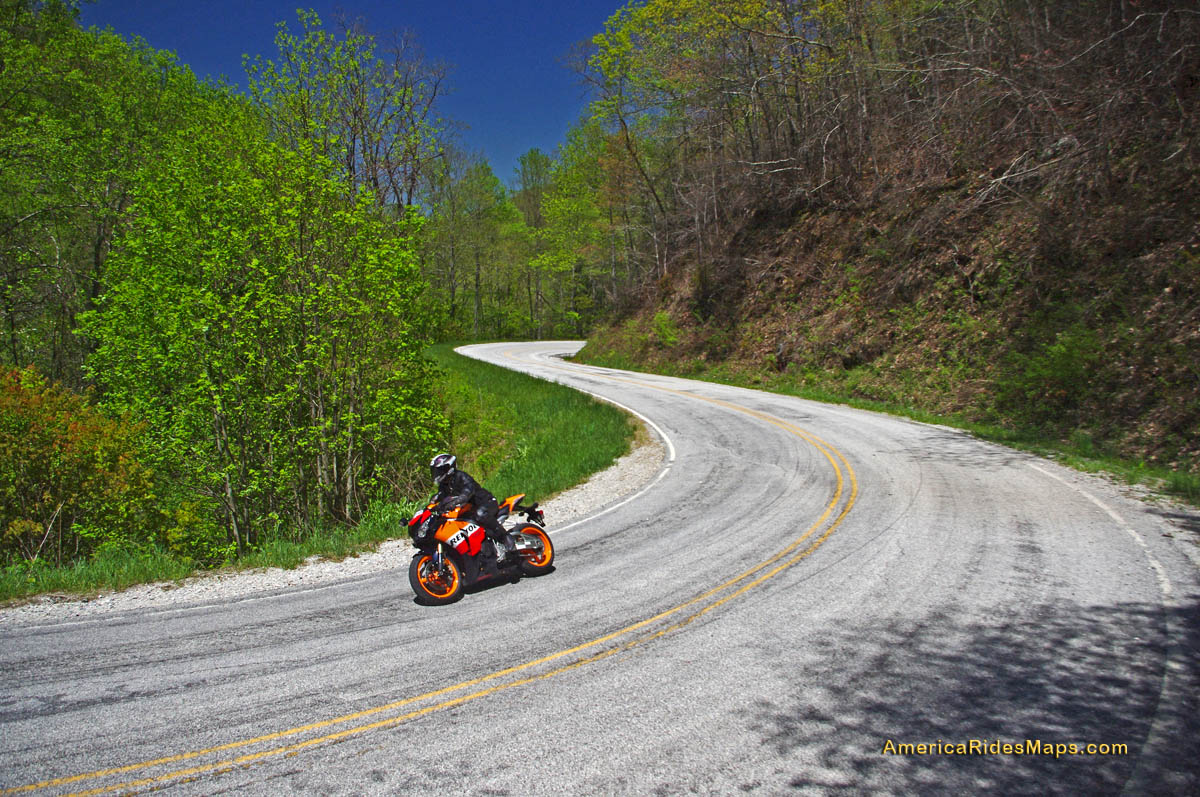
The Ducati 848 made enjoying the canyon rides at a spirited pace easy. While the suspension was set up way to stiff for my liking, it always provided as much traction as I asked for, the bike ran the curves like it was on a rial. It was a challenge to keep from hitting triple digits when the road opened up, a challenge I failed many times.

Photo-bikes-on-CA-58

A long twisty section makes CA 58 so great

Once over the mountains I came down into the oil fields and farmlands near Maricopa. I then headed north through the desert where temps were just shy of 100 degrees to pick up the next great ride near McKittrick, CA 58. Fortunately, I’d topped up the tank as the “No services next 70 miles” signs appeared. CA 58 was another outstanding ride through high open mountain passes, great curves, and  a whole of of fun. Lot’s of bikes on this ride, it’s a great one so long as you’re up in the mountains. Once you come down, things straighten out again. I was reminded of the midwest where you ride a road that runs like an arrow to the horizon for miles and miles until you come to a 20 mph right angle turn to do it all over again and again.

photo-wine-country

Cruising through wine country on Foxen Canyon and Santa Rosa Rds

I got bored on these long straight runs and after a while the speed crept up and up until I was playing a game to see if I could launch the bike off the hilltops as a the Ducati stretched it’s legs out and sang at the top of it’s booming baritone voice. I looped back through Santa Margarita then limped into San Luis Obispo with the reserve light crying out for a drink of fresh petrol. I wasted a bit of time looking for gas as every station was flagged off with yellow tape. They were all getting some kind of service done and I was running on fumes when I finally found one that had one bank of pumps in operation. I waited my turn in the long lines that had formed, then headed south on the freeway to return home.

Photo-coastal-fog

The coastal fog travels well inland and persists till after noon - Foxen Canyon Rd

The next day I headed north this time, taking CA 154 through the dense morning fog that rolls in off the ocean. My destination was Foxen Canyon Rd, a decent ride, but not as challenging as those I’d previously been on. Most of this day was in wine country and it was more scenic then I’d seen on the east side of the mountains. I worked my way from Santa Maria to Lompoc, then found a nice ride on Santa Rosa Rd. Passing through Solvang, I returned to Santa Barbara on CA 154, then got on the freeway and went back south to Carpenteria to make a few more runs on CA 33.

So how do the California motorcycle rides I was on compare to the Blue Ridge & Smoky Mountain motorcycle rides I know so well?

Photo-Ducati-848

The Ducati 848 - a precision guided missile - too much for all but the best riders

While the California rides were longer, so were the distances between them – they stood in isolation. Here in the Smokies, you finish one great road to continue your motorcycle ride on the next. You spend far more time in the nice sections and finding a long straight stretch of road means you made a wrong turn and left the mountains. I missed the green trees, the rushing mountain streams, the little waterfalls around the bends. The California countryside is dry, if not desert, close to it. Towns are much further apart, and you’ve got to pay attention to gas stations – when in doubt, top it out. You may have a long ride before you find another.

Photo-oil-derricks

Sometimes there are more oil derricks than trees

Many of the California roads were rough and bumpy – a patchwork of asphalt and concrete layer upon layer. I thought we had some rough rods, but I’m beginning to think we don’t have it so bad after all.

In the same amount of area I covered to reach just a few great motorcycle rides in California, there would have been a hundred or so in the Smokies and never  a 4 lane road or highway needed. I continue to believe there are more great motorcycle rides in the Blue Ridge and Smoky Mountains than any other area of the country.

To quote the now ex-governator, “I’ll be back”. Admittedly, I’ve barely touched the huge state of California. It’s a nice contrast to the motorcycle rides we have back home in the Smoky Mountains and makes me appreciate how great we’ve got it back east.

_______________________________________________________________________________

Wayne Busch
Wayne Busch – Cartographer
– Wayne Busch lives in Waynesville, NC, where he produces the most detailed and comprehensive and up-to-date motorcycle pocket maps of the Blue Ridge and Smoky Mountains to help you get the most of your vacation experience. See them here – AmericaRidesMaps.com 

Ever seen the Dragon’s Breath on your Deals Gap motorcycle ride?

NC-28-motorcycle

The Dragons breath envelopes riders on NC 28 near Deals Gap

OK, so I made the Dragon‘s Breath thing up – at least the name. The phenomenon is real though, something you may encounter when riding NC 28 along Cheoah Lake on your way to or from The Dragon at Deals Gap.

NC-28-Fontana-lake

NC 28 - Cheoah Lake fog (or is it?) - Remember, there's a Dragon nearby.

The fog, which can be pretty thick at times, is a common occurrence on warm summer days. The water which drives the turbines at nearby Fontana Dam is drawn from the deepest coldest depths of Fontana Lake. When there is enough moisture in the warm air, it condenses when it comes near the cold water of Cheoah Lake.

NC-28-fontana-lake-

NC 28 - Sometimes the NC 28 bridge below the dam sits on a cloud

Fontana-Dam

Below the Fontana Dam

A nice side trip when you are in the area is a stop at the Fontana Dam. You can access the bottom of the dam once you cross the bridge over Cheoah Lake. Turn right and follow the paved road to the power station. To see the dam from the top, and you should it’s one of the highest in the east, use the road which intersects NC 28 just beyond Fontana Village. It’s easy to find, it’s the only stop sign on NC 28.

You find NC 28, the Fontana Dam, The Dragon, the Cherohala Skyway, other nearby attractions and scores of two lane twisty back roads which make for great Smoky Mountain motorcycle rides on America Rides Maps;

_______________________________________________________________________________

Wayne Busch
Wayne Busch – Cartographer
– Wayne Busch lives in Waynesville, NC, where he produces the most detailed and comprehensive and up-to-date motorcycle pocket maps of the Blue Ridge and Smoky Mountains to help you get the most of your vacation experience. See them here – AmericaRidesMaps.com 


My Search for the Best Mountain Motorcycle Rides Never Ends

Photo - Maple Springs Observation Point

The Maple Springs Observation Point - accessed from Santeetlah Rd

Friday’s search for great Smoky Mountain motorcycle rides, which culminated with a spirited cruise on the Cherohala Skyway, was one of those days that might be looked on as not so productive. It’s not that I didn’t catalogue some good mountain motorcycle riding roads, I added several which will appear on my new map of the area. In my quest to leave no stone unturned, much of the 400 miles I covered was spent on roads which only the most adventurous would bother to travel. Still, there are sights and places some may wish to see, and I’m determined to find as many of them as I can.

Photo - Cherokee National Forest View

View from the Maple Springs Observation Point. I was told you can see 5 states from this spot.

Considering the number of motorcycle riders who are drawn to the area by such notable roads as The Dragon at Deals Gap, the Cherohala Skyway, The Tennessee Foothills Parkway, NC 28 (now renamed “the Moonshiner 28“), finding others that compare in quality is pretty much futile. These are some of the best motorcycle rides in the world. I’m not holding my breath thinking I’m going to discover the next great classic motorcycle ride. So why go to all this effort?

Photo - Santeetlah Dam

Quiet morning at the Santeetlah Dam

There are probably millions of motorcycles that pass through here each year. In most cases, they come, they ride the famous roads, get the t-shirt, then they’re gone to other places following the crowds. It’s the notable roads that get all the attention. Once experienced, it’s back on the four lane or the congested tourist arteries to reach the next great spot. You can rack up a lot of miles playing connect-the-dots, though those droning plods on the connections are the price you pay to reach those popular motorcycle rides.

Photo - Bald River Falls

Bald River Falls

It doesn’t have to be that way. I’m filling in the gaps between the famous motorcycle rides with the best quality rides I can find so connecting the dots is as much of an adventure as the roads you’re trying to reach. Where others might show you one good way to get from point A to point B, I look for all the best ways.

Photo - Cherohala Skyway View

View from the Cherohala Skyway. The Smoky Mountains were especially smoky today and I'll get more photos another time.

Who want’s to spend their time on the 4 lane or in bumper to bumper tourist traffic when there are so many empty two lane scenic and challenging mountain roads that get bypassed? It’s often as simple as crossing over to the next valley to escape the congestion. One little turn can make the difference between cruising along with the wind in your face or cursing the throngs of dawdling codgers, gawking sightseers, lumbering RV’s, and belching commercial trucks struggling up the grades to deliver their wares.

Photo - Motorcycles on the Cherohala Skyway

Bikes on the Cherohala Skyway

I’ve catalogued more than 100 good motorcycle roads so far surrounding Great Smoky Mountains National Park. I’m not done yet. Some of these are outstanding rides. Others will satisfy those looking for adventure. All of them avoid most everyone else who’s come to enjoy the Smoky Mountains just like you and take you to the places they’ll never see while getting you where you want to be.

Keeping you going is what keeps me going. I’m closing in on finishing the map of the Best Motorcycle Rides North of Great Smoky Mountains National Park. Stay tuned and see what I discover. It’s all for you. (Click on the photos for the large versions)


http://www.youtube.com/watch?v=xBbQfR2GqMc

_______________________________________________________________________________

Wayne Busch
Wayne Busch – Cartographer
– Wayne Busch lives in Waynesville, NC, where he produces the most detailed and comprehensive and up-to-date motorcycle pocket maps of the Blue Ridge and Smoky Mountains to help you get the most of your vacation experience. See them here – AmericaRidesMaps.com