Best Motorcycle Rides, NC – Wayah Road

Best Motorcycle Rides, NC – Wayah Road

Best Motorcycle Rides In NC

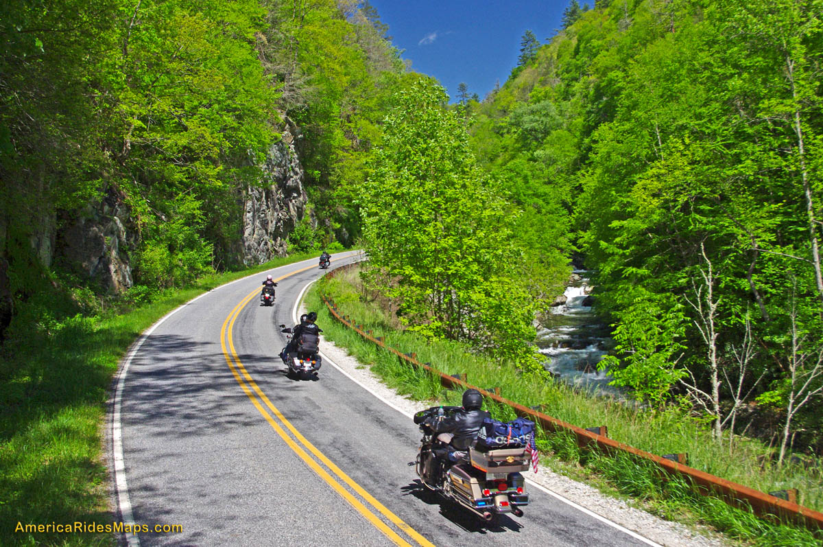
Best Motorcycle Rides In NC – winding up Wayah Road from the Nantahala Gorge.

30 mile long Wayah Road connects US 64 near Franklin, NC to US 74 in the heart of the Nantahala Gorge near Topton, NC. It’s a useful and strategic road to know of as it’s the only one that cuts through this rugged section of high mountains and national forest and it points to the Dragon at Deals Gap. While the ride lacks panoramic long range mountain views, there is plenty of scenery along the whitewater river. Clear and sparkling alpine Nantahala Lake is a treat near the top.

Best Motorcycle Rides, NC - Wayah Road

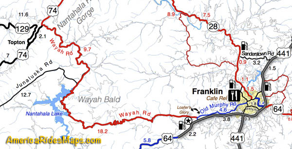
Best Motorcycle Rides, NC – Wayah Road – section from Map #7. Only main roads shown. Other great rides near here.

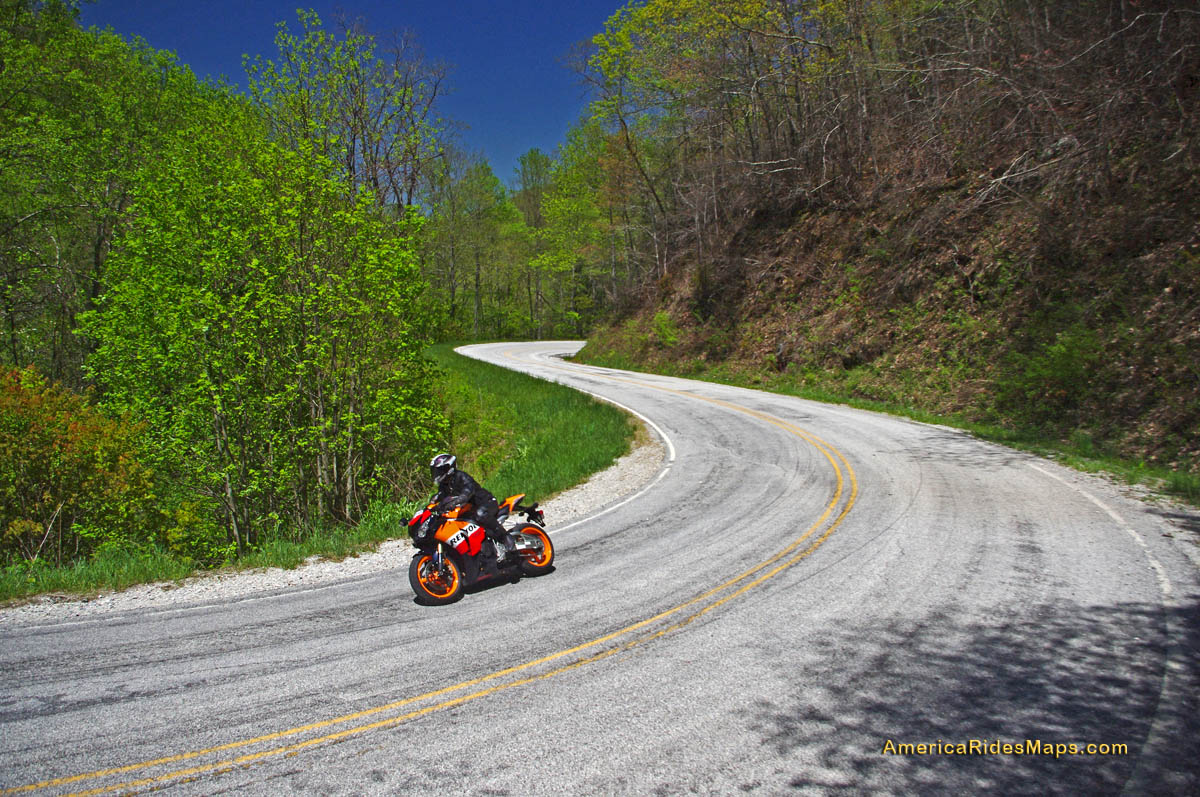
The climb out of the depths of Nantahala Gorge is steep and twisty right from the start by the powerhouse. It follows the  bank of the river as it cascades down the slope from the lake above, crossing it on narrow bridges a few times. You may run into fishermen along the lower stretch, otherwise there’s little traffic.

Best Motorcycle Rides, NC - Wayah Road - Waterfall along Wayah Road

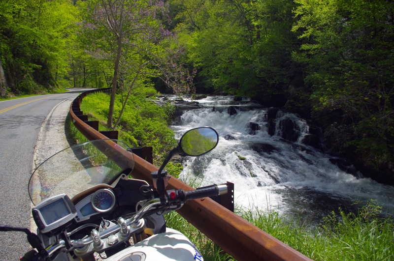
Best Motorcycle Rides, NC – Wayah Road – The ride along the river on Wayah Road is spectacular!

When you reach the top of the climb, the road relaxes and rolls across the heights of the mountain passing through the small community near the lake. The road gets tight again along the shoreline of the clear deep lake, then climbs a bit more to reach the gentle run across the high stretches of Wayah Bald. This last short climb has some very tight turns and is notorious for gravel drawn into the road from unpaved driveways. There is a small restaurant on the lake and a few places to pull off for a break or photo.

Best Motorcycle Rides, NC - Wayah Road

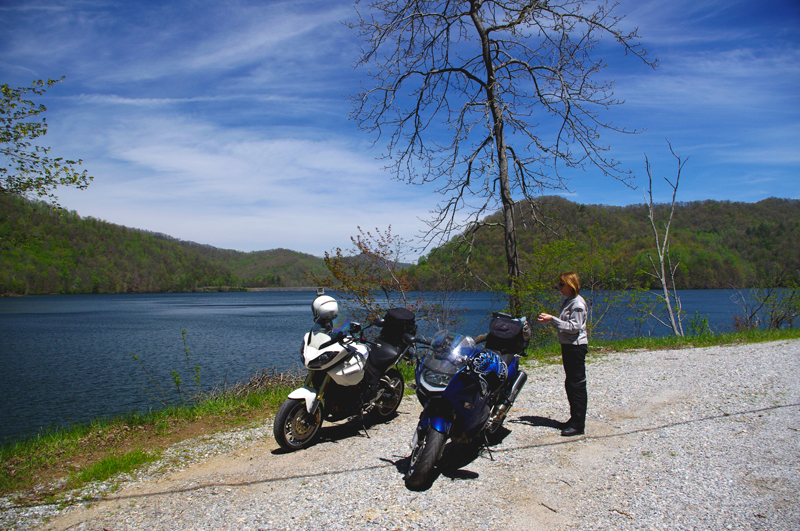
Best Motorcycle Rides, NC – Wayah Road – Picnic lunch at alpine Nantahala Lake

There’s a steep plunge down the eastern slopes with some true hairpin curves. You emerge in a tight valley that grows wider as you approach Franklin. The east end of Wayah Road is marked by ‘Loafer’s Glory” country store and gas station (click her for Yelp review). Wayah Road ends when it reaches Old Murphy Road. Four lane US 64 is half a mile south on Old Murphy Road or you can follow Old Murphy Road about 5 miles in to downtown Franklin.

Best Motorcycle Rides, NC - Wayah Road

Best Motorcycle Rides, NC – Wayah Road. The curves at the top of the climb are some of the most severe and the most fun. Be alert for gravel in these turns.

Wayah Road is a classic so you’ll find it on the “12 Classic Deals Gap Motorcycle Rides” pocket map from America Rides Maps. Do yourself a favor and look at Map #7 if you are coming to ride in this area. “The Best Roads South of Great Smoky Mountains National Park” covers this are in detail. I’ve only hinted at the many nice rides near Franklin with the snippet of map I’ve shown.

Get The most detailed Maps Here – America Rides Maps

If you enjoy photos of motorcycle riding in the Blue Ridge and Smoky Mountains, like MY BLUE RIDGE MOTORCYCLING FACEBOOK PAGE.Facebook

____________________________________________________________________

wayne busch - Smoky Mountain Motorcycle Rider.com

Wayne Busch

– Wayne Busch lives in Waynesville, NC, where he produces the most detailed and comprehensive and up-to-date motorcycle pocket maps of the Blue Ridge and Smoky Mountains to help you get the most of your vacation experience. See them here – AmericaRidesMaps.com

____________________________________________________________________

Motorcycle + Ice + Fun = Minor Damage

A minute after this photo was taken my bike lay on its side and I couldn’t pick it up.

Photo-Whitesides-mountain-nc-motorcycle-by-frozen-lake

A minute after this photo was taken my bike lay on its side and I couldn't pick it up. Whiteside Mountain in the background has the highest cliffs in the east.

It was the last of the roads I planned to explore on a winter motorcycle riding dayin the Blue Ridge Mountains. I stopped at this frozen lake to take the picture beneath the 1000 foot cliffs of Whiteside Mountain. As I tried to turn the bike around and leave, my foot slipped on the icy gravel and down it went. Each time I tried to pick it up the wheels just skated on the frozen ground and I couldn’t get the leverage to lift it. Within minutes I was exhausted, out of breath, and starting to seriously wonder just how I was going to get out of this predicament.

Photo-motorcycle-on-icy-US-276

I didn't realize how icy US 276 was until I stopped. My feet skidded on the thin coat of black ice that covered parts of the road. It had been a long slow climb to get this far.

Had I any sense I would have turned back this morning and put this off, but I’ve set a deadline for this motorcycle ride map revision. After several days of a hard cold followed by rain, I figured the roads should be in better shape now with the relatively warmer weather. When the frostless morning came with 33 degrees on the thermometer and the promise of sunshine, I was elated to get back out on the road. It wasn’t as warm as I thought.

Photo-view-of-mountains-in-clouds-from-Blue-Ridge-Parkway

As I looked south when I crossed the Blue Ridge Parkway my destination lay beneath that bank of clouds near those mountaintop islands on the left horizon.

Heading out things appeared to be fine. The rains melted all but the last clumps of snow the plows had skidded to the roadside. The ride out through the Bethel Valley was as usual. Once I entered the Pisgah Forest and started the winding climb to crest the Blue Ridge Parkway it got interesting.

photo-motorcycle-on-snowy-US-276

I thought conditions would get better once I started down the south side of the mountains but if got worse until I reached US 64 in Brevard.

This is where I’m supposed to entertain you
with how hard it was, how bad the roads were,
that it was all harrowing moments
of slips and slides and near spills –
That’s not how I recall it.

I play with conditions like these,
flirting with the balance
at the the edge of control.
Find the sweet spot of the given moment,
do my best to guide the slides,
find the rhythm of the road,
and push as far as I dare let it go.
That’s what I remember –

It took 2 hours instead of one
to reach the South Carolina border,
but once I came down off Caesar’s Head
the ice was gone.

Photo-table-rock-south-carolina

Table Rock in Table Rock State Park, South Carolina, viewed from US 276 coming down through the hairpin turns that descend from Caesar's Head State Park.

I picked up a few new roads in South Carolina for you to enjoy on your motorcycle vacation tour this year including one that was so promising I’m going to research the potential for mapping in that area. While I had to be vigilant for salt and sand, I had lots of fun on motorcycle rides old and new to me. As soon as I crossed back into North Carolina the snow and ice was back.

photo-winter-view-lake-jocassee-sc

A view of Lake Jocassee, SC from the Wiginton Scenic Byway as I climb back into snowy North Carolina. Whitewater Falls, highest in the east, feeds the lake.

I knew it was probably a waste of time to ride out into Whitesides Cove, but I know this great spot to get a picture. There’s always the chance the unpaved portion to Highlands has been improved. Unless I check periodically I don’t know when one of these two lane twisties has had an upgrade and is worth adding to my Blue Ridge motorcycle ride maps.

Photo-ice-on-NC-215

By spring these rocks on US 215 near the Beech Gap exit of the Blue Ridge Parkway will be coated with ice several feet thick.

You already know I got out of the jam. It sure wasn’t pretty. For a second I thought – “take a picture of this”, then a wiff of gasoline told me the longer it the bike lay there the less likely it would start. Little chance of someone passing by to help on this isolated road. The sun was getting low, things were already frozen, it would be a long cold night.  It was time to be working my way home.

Photo-broken-lens

New lens already on order

I flushed with adrenaline when those thoughts hit, carefully considered the mechanics, dug my feet in, and with my back to the bike I half lifted-half wresteled the beast up with a quivering slo-mo almost failed heave. A broken turn lamp lens lay on the ground, the mirrors had twisted out of position, but otherwise the mud would wash away when I got home.

Hooray – I think that completes the roadwork I needed to finish up this new motorcycle ride map. I plan to have it ready by Christmas. It not only combines 2 existing maps into one, but adds more than a dozen new motorcycle roads I’ve never published before. It also gets nearly all the roadside waterfalls on a single map. This will be one of my most popular ride maps yet!

Visit America Rides Maps.com – the most inexpensive & comprehensive motorcycle ride maps available

_______________________________________________________________________________

Wayne Busch
Wayne Busch – Cartographer
– Wayne Busch lives in Waynesville, NC, where he produces the most detailed and comprehensive and up-to-date motorcycle pocket maps of the Blue Ridge and Smoky Mountains to help you get the most of your vacation experience. See them here – AmericaRidesMaps.com 

Photos from Todays Motorcycle Ride in the NC Mountains 12-9-10

It was noon before the temperature finally crested freezing, though I’m not sure it ever reached the predicted high of 35.  The sky was blue, the sun was shining, and the roads were dry. I couldn’t stand it any longer and had to get out on the bike.

Photo - motorcycle and snow in NC

Shady spots on the north side of the mountains still held snow, but mostly it was gone. Roads were in pretty good shape. This is at Hookers Gap. Saw a Post-lady but no hookers. Probably too cold.

I ended up covering about 200 miles today, most of it riding back and forth on the roads which run between Liecester and Marshall, North Carolina. The majority of the key roads have already been discovered for this motorcycle ride map I’m working on. What I’m seeking now are  the best ways to link them together and show you how to make connected rides that keep you cruising along without hitting traffic or four lanes or the interstate.

Photo - Potato Branch Rd near Liecester, NC

I think this is a section of Potato Branch Rd. It's one of my new favorites. You can link-ride it all the way back to the Blue Ridge Parkway or out to Hot Springs and beyond.

This area is only minutes from downtown Asheville. It doesn’t take long to “get lost” in the mountains surrounding the city. Outside of paving, these old roads have changed little in more than 200 years. They twist and wind through older neighborhoods, farmlands, homesteads and old barns, following the path of least resistance over mountain passes and along rushing streams and rivers.

Photo - A winter scene near Liecester, NC

Winter riding may not be as frequent as during the warmer months, but it has it's rewards. I enjoy it as much as the rest of the year. This might be Early Mountain Road.

I also took a ride over by Cherokee to investigate a road which I thought I’d overlooked. As is too often the case, there was a good reason to ignore it – it was another one of those half-paved roads that lead up into mountain coves. They start out nice enough but once the grade gets steep the pavement ends. Rarely does one go through and you can waste a lot of time riding up dead end roads. I’m out discovering those roads which DO go through and are worth the ride. It was a very successful day.

_______________________________________________________________________________

Wayne Busch
Wayne Busch – Cartographer
– Wayne Busch lives in Waynesville, NC, where he produces the most detailed and comprehensive and up-to-date motorcycle pocket maps of the Blue Ridge and Smoky Mountains to help you get the most of your vacation experience. See them here – AmericaRidesMaps.com 

Video – Fall Leaf Status – a Motorcycle Ride on NC 209

http://www.youtube.com/watch?v=en5xcyY_kcc

A compilation of video clips from a weekend motorcycle ride to Hot Springs, North Carolina to show the current status of the fall leaf color in the Smoky Mountains.

Jackie and I have been out enjoying the fall colors at every chance. I shot this video on an afternoon ride out to Hot Springs to see what the leaves looked at in the lower altitudes. Some of the leaves have already dropped at the higher elevations on the Blue Ridge Parkway. We saw some nice color near Linville and also near Soco Gap and the lower areas of the Blue Ridge Parkway near Waynesville.

There’s still a surprising amount of green on the trees so this show will go on for a while longer. It’s not as dramatic as when everything comes in at once, rather, you stumble across pockets of it here and their that are really nice. I hope the mild weather continues as I have more roads to explore for America Rides Maps before the winter starts to limit my rides.

_______________________________________________________________________________

Wayne Busch
Wayne Busch – Cartographer
– Wayne Busch lives in Waynesville, NC, where he produces the most detailed and comprehensive and up-to-date motorcycle pocket maps of the Blue Ridge and Smoky Mountains to help you get the most of your vacation experience. See them here – AmericaRidesMaps.com 

Good News / Bad News at Onion Mountain Road Near Franklin

Photo - work on Onion Mountain road

For a road that is going nowhere, they are doing a nice job of getting you there. Lets hope they find the funds to finish it this year.

On my way back from Georgia I decided to make a detour to investigate the progress on Onion Mountain Road east of Franklin, NC. This is one of my “pet” roads, one I’ve been watching ever since they started paving it last year. The work completed prior to the winter shut down really got my hopes up that this ridge top two lane would eventually be completely paved once warmer weather returned. The good news is the crews are back at it.

The bad news though, puts a damper on the whole situation. I was excited to follow a dump truck up the winding road, though a little dismayed to see the weight of the passing trucks was already damaging what had been an excellent paving job. Proceeding out onto the gravel section (no change from where  it had begun last year), I soon ran into the work crew. They have no expectation to complete the paving all the way through this year, funding has been cut. Why they are bothering with what they are doing is a mystery to me, it will be just another road to nowhere.

I’ll keep watching. Once paved, Onion Mountain Road will link a number a great motorcycle roads and allow you to avoid pretty but heavily trafficked US 64. I went ahead and added more of the surrounding roads to my America Rides Maps motorcycle pocket map “The Best Roads South of Great Smoky Mountains National Park – WEST” and am considering adding a few more once I give them another look. We’ll see how things develop.

_______________________________________________________________________________

Wayne Busch

Wayne Busch - Cartographer


– Wayne Busch lives in Waynesville, NC, where he produces the most detailed and comprehensive and up-to-date motorcycle pocket maps of the Blue Ridge and Smoky Mountains to help you get the most of your vacation experience. See them here – AmericaRidesMaps.com


Full Service Motorcycle Tour Company in Charlotte Area – Blue Strada Tours

Bill-Kniegge-Blue-Strada-Tours

Bill Kneigge

Isn’t it great when you come across those people in life whom everyone can’t help but like? Happy, enthusiastic, uplifting, and full of passion, they not only make your day but you can’t help but want to spend more time with them. I had the privilege and pleasure of meeting Bill Kniegge through the Asheville Bikefest when he provided exemplary service as one of the tour guides for that inaugural four day event. You may count on hearing more of him in the future, he’s one of those people you WANT to do business with.

Photo-Bill-at-Backbone-Rock-Tennessee

A photo from Backbone Rock, Tennessee, in one of the premier riding areas in the Smoky Mountains

With 30 years in the motorcycle and motorsports industry and involvement with brands like Bell Helmets, Husqvarna and ATK Motorcycles, Ford Motorsports, and his love of riding and competing since the age of 12, Bill Kniegge, brings his knowledge, desire, and passion to Blue Strada Motorcycle Tours putting together premier two-wheel experiences for the motorcycle vacationer.

Blue Strada Motorcycle Tours & Rentals is a Motorcycle Touring company based in the Charlotte area.  The company provides motorcycle riders with all-inclusive 5-8 Day tours of the Appalachian mountains, including the Blue Ridge and the Smokys.  Tour guests can ride their own motorcycles if they desire or pick from a series of Suzuki V Strom, BMW and Yamaha Touring bikes. Tour leaders are experienced with the roads and Tour guests arrive at their lodging to find their luggage already in their rooms… Kniegge is a self admitted “Foodie” and thus provides great choices for dinners and lunches along the way.

Photo and the Fiddling Pig

An admitted "foodie", Bill and company enjoy the dining as much as the riding.

Blue Strada Motorcycle Rentals are a important part of their business.  Riders that want to ride their own pace in the mountains can do so very easily.  Blue Strada provides help in searching for great roads to ride, a variety of lodging based on price points and will also deliver and pick up bikes from Charlotte area hotels and airport if needed.

Photo-Bill-Kniegge-Blue-Strada-Tours

Quality endures - Bill and a classic Beemer

Look to the Blue Strada web site as a trusted source for motorcycle rentals and high quality touring experiences and consider working them into your motorcycle vacation plan. Whether it’s the Blue Ridge Parkway or any of the thousands of miles of superb back roads in the Smoky Mountains you seek to enjoy,  Bill and his team will do you well. Experience excellence in motion with Bill Kniegge.

http://bluestradatours.com

A Good Tip Leads to More Great Motorcycle Rides Near the Dragon

Droning west on the Great Smoky Mountains Expressway this morning, my mind tends to wander. The greatest challenge of the highway is simply maintaining the legal limit leaving plenty of brain cells free to engage in other things. My wife rides alongside on her Beemer so I have something to look at every once and a while and count my blessings of how fortunate I am to have someone like her to come along with me today. The thought that comes to the forefront is “Just how many motorcycles are there on the road?”

It was far easier to snap a photo on the rare straight stretches - overall the roads were wonderfully curvy.

As the main artery between the Blue Ridge Parkway and the Dragon at Deals Gap, it’s no wonder there are a lot of motorcycle riders on this stretch of highway 23 / 74. Both the Parkway and the Dragon draw millions of two wheeled vacationers to the area every year. Still, we’re a good bit east of Cherokee, the southern endpoint of the Blue Ridge Parkway, and within minutes we’ve passed scores of bikes headed in the opposite direction.

Photo-motorcycle-follows-nice-views

The roads we explored followed winding streams and creeks through rolling farm lands in a broad mountain valley. Plenty of great long range views.

We’re only going as far as NC 28 south today, about 45 minutes ride time to reach Lauada, and early on I wonder if we’ll pass 100 riders. I start to keep a loose count, but within 20 minutes or so it’s obvious the number will easily exceed that, and question answered, my mind drifts to other things. Turning off the highway onto two lane NC 28 we plunge south into the twisties and the bikes keep sweeping past us in the other direction.

Photo - Jackie rounds a curve

The pavement is generally excellent for back roads, and you can enjoy the ride with gusto. Just be wary for a little gravel now and then.

I’m following up on a tip from Brad at the Deals Gap Motorcycle Resort. I spent some time with him Friday and he suggested I revisit an area I’d previously sketched over. I knew there were a couple of nice rides hidden away around Franklin, but he hinted they could be linked together to make a nice route. I’d done some scouting on the way home that day, and I saw promise. Today was the day we’d put it all together and see if it added up to getting a place on my America Rides Maps.

Photo - Jackie leads

The only traffic we found was when we approached the main road. If you stick to the perimeter route you'll see very little if any and it's more curvy and fun.

It took about four hours for a thorough assessment. We checked out every one of the roads in the area, confirmed the unpaved areas remained so (I only focus on paved roads), the dead ends were still dead, and the links that joined the roads together followed a more or less natural flow or the turn points were easy enough to locate. When we completed our task, I had assembled an outstanding ride that will certainly be the next addition to America Rides Maps. I’ll add it tomorrow morning.

Photo - a day meant for riding a motorcycle

I highly recommend NC 28. These roads make it even better. Great to know when there's traffic. You can jump off and enjoy the ride again.

I make a claim to know almost every great motorcycle ride from North Georgia to North Virginia. While I can’t claim I know them all, I’ve just learned another, and we saw only one other bike the whole time we were exploring the area. Now that’s what I’m looking for.

America Rides Maps

Photos of Blue Ridge Parkway Damage Near Linnville

Despite the threat of rain, not an idle threat by the time I headed home, I rode the motorcycle up to Little Switzerland this morning to do some recon on the Diamondback Motorcycle and Sportscar Route. I’d started to add it to the appropriate maps and realized I needed to refresh my recollections. It was nice to revisit NC 226A. I had it all to myself early in the morning and took the appropriate measures to enjoy it with full enthusiasm much to the dismay of several groups of wild turkeys that were enjoying an early morning stroll. I’m sure they heard me coming at the Switzerland Inn as I spent the last micrometers of my rear tire spinning out of the turns.

Photo-Table-Rock-NC

The most dramatic profile on the horizon, Table Rock, NC viewed from Fish Hatchery Road.

After meeting with Gary at the Switzerland Inn, I returned down the mountain at a relatively passive pace to scope out suitable locations for filming shots, then headed south on NC 221 to ride the Lake James Loop. I snapped the first photo of Table Rock (above) from Fish Hatchery Road as I skirted along the north shore of Lake James. It holds a dear place in my heart from my rock climbing days of yore.

Photo-Table-Rock-north-profile

Hard to believe this is the same geologic feature, but you can see why the sheer 400 ft cliff faces are popular with rock climbers. Table Rock viewed from NC 181.

The second photo of Table Rock shows it in dramatic profile when viewed from the north on NC 181. Long a favorite road for motorcyclists, NC 181 makes the climb from Morganton to the Blue Ridge Parkway. The broad sweeping curves and occasional passing lanes make it a run that is (sometimes) done at speeds in excess of the posted limit  (no, not me, never).

Photo-section-of-the-Blue-Ridge-Parkway-damage-near-Linnville

The volume of trees down on the section of the Blue Ridge Parkway near Linnville is amazing. This may be one of the last sections to open.

The final section of the Lake James Loop returns to the Switzerland Inn via the Blue Ridge Parkway. While the section south of Little Switzerland is slated to open on Friday, these photos of the parkway north show how much is yet to be done. The volume of downed timber is unbelievable as the photos show.

Photo-trees-down-on-Blue-Ridge-Parkway-near-Linnville

As far as the eye can see in both directions, the Blue Ridge Parkway is totally impassable due to the amazing number of trees that fell this winter.

With this section of the Blue Ridge Parkway still closed (for obvious reasons) I took another route home. It will be impressive if this mess gets cleared by the end of the month. As soon as it does, expect a new video of the Diamondback and the Lake James Loop.

For local info contact the Switzerland Inn at http://switzerlandinn.com

To learn more about the Diamondback Motorcycle and Sportscar Route go to http://diamondbacknc.com

To get a free pocket sized post card map of the Diamondback, email info@americaridesmaps.com with you mailing address.

Motorcycle Friendly Lodging – Maggie Valley, NC – The Chalet

Photo - Maggie-Valley-Chalet

Motorcycle Friendly Lodging at the Chalet

The Chalet in Maggie Valley offers a quiet off highway setting for all individuals, no matter the number of wheels, that desire spotless accommodations.

Photo-Maggie-Valley-Chalet

Private, secluded, secure, peaceful, and friendly - What more could you ask for?

We offer all paved easy access, plenty of trailer parking,  bike/car washing area, rag bucket,  and even some garage parking.Our location is secure and bikes are not visible to traveling public.

Photo-View-of-room-at-Maggie-Valley-Chalet

Now that's what I'm looking for at the end of a good day of riding!

The vast lawn area with gas grills, horseshoe pit and enclosed hot tub is ideal for socializing.

Photo-View-of-room-at-Maggie-Valley-Chalet

Comfortable, relaxing, all you need to feel at home

Our units are all studios or suites with kitchens excellent for small groups of up to 30. Most of our guest come back yearly to enjoy the comfortable accommodations we offer.

Photo-Facilities-at-Maggie-Valley-Chalet

They have all you need to make sure your bike has a nice stay too!

For more info contact http://www.mvchalet.com

Motorcycle Friendly Lodging – Maggie Valley, NC – Creek Wood Village Resort

I’ve found another place which welcomes the motorcycle vacation traveler looking for a place to either spend the night or base out of to enjoy the hundreds of miles of great motorcycle rides just over the hill. It’s just a few miles off the Blue ridge Parkway from the Soco Gap exit.

Photo - aerial view of the cabins on the roaring creek

Aerial view of the cabins on the roaring creek at Creek Wood Village Resort

Photo - motorcycleCreek Wood Village Resort is located in the heart of Maggie Valley, directly behind the Maggie Valley Festival Grounds on three and one half FLAT acres with easy access for motorcycles and trailers. It’s convenient to most everything in town including the restaurants, shops, waterholes and Wheels Through Time motorcycle museum.

They have one, two and three bedroom cabins, all with full kitchens, fireplaces, color cable T.V. and the most beautiful views of the mountains.

Photo - one of the cabins

Historic and comfortable cabins are waiting for you.

No hectic life style here. Just kick back and set on your porch, enjoy the mountains, reflect your day in the quiet pond or listen to the water rushing through the nearby creek,  and take in the views after a great day of riding some of the best touring rides around.

Totally motorcycle friendly, they also have two fishing ponds and 650 foot of rushing creek.