Blue Ridge Parkway 2013 Detour Map for Motorcycles
Location: North Carolina, Milepost 358, 2.6 miles south of NC 128 / Mt. Mitchell State Park.

Blue Ridge Parkway Detour 2012 – 2013 – Amazingly clear skies from the Craggy Gardens Overlook on the Blue Ridge Parkway. It can still be accessed from the south. That brown stripe in the distance in I-26 more than 22 miles distant. Visibility must have been nearly 50 miles this day.
Schedule:
- Road open both lanes until 9/26/12
- 9/26/12 – 10/01/12 – One lane closed. Temporary traffic lights for one way traffic
- 10/01/12 – April, 2013 6.5 miles of road closed, use detour
> Access Mt. Mitchell State Park from north (NC 80 crossover)
> Access Craggy Gardens from south (Asheville / Weaverville exits)
A short stretch of the Blue Ridge Parkway will be closed November 1, 2012 through April 2013 to stabilize a failing slope. I’ve been watching this spot in the road as it has subsided over the past couple years. It involves all of the north bound lane and a portion of the southbound lane, and it’s very noticeable dip when riding through.
On or about September 26, Temporary traffic lights will stagger one way traffic through the work area, expect short to moderate delays. Gates above the Craggy Gardens Picnic Area and just south of NC 128 to Mt Mitchell State Park will be closed November 1 to isolate it for the construction.

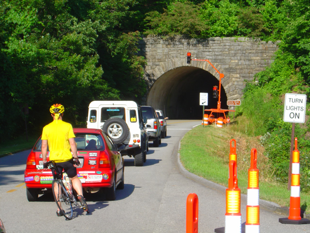
Blue Ridge Parkway Road Closure 2012 – 2013 – Temporary trffic lights like this one will regulate the flow when one lane is closed this week.
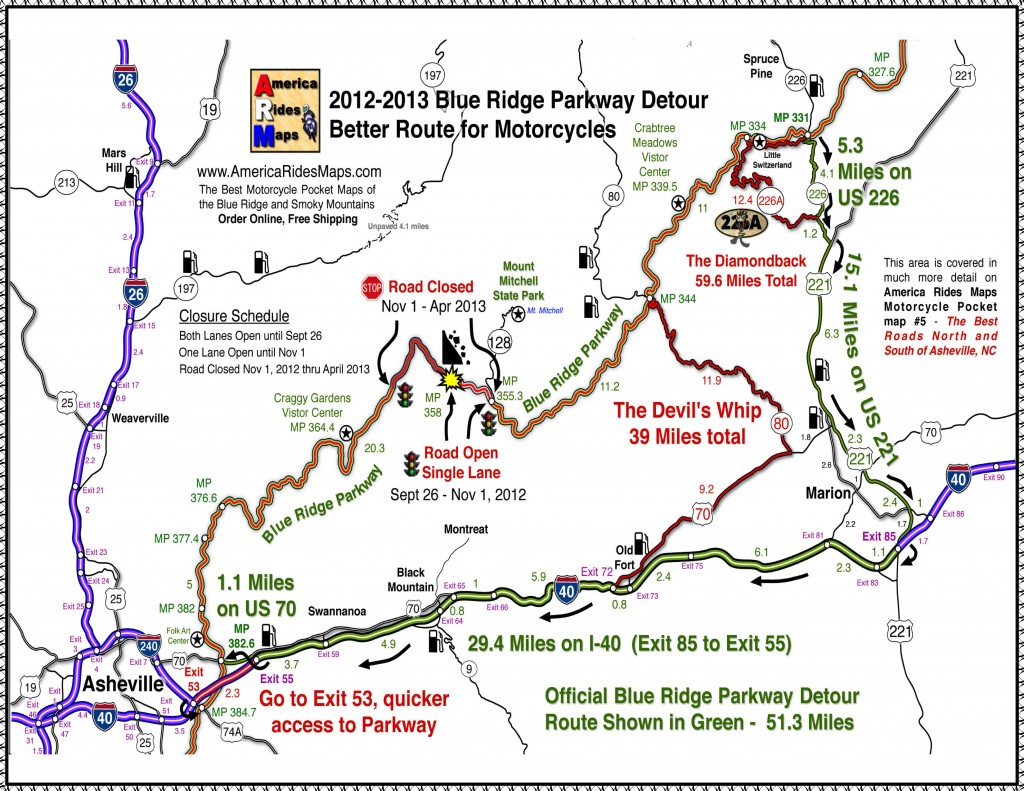
The Official Blue Ridge Parkway Detour exits at NC 226 at Spruce Pine, following it south to NC 221 then west on I-40 to reconnect in Asheville at the US 70 intersection.
I suggest those motorcycle riding on the Blue Ridge Parkway continue south and exit the Blue Ridge Parkway at NC 80. NC 80 a.k.a the “Devils Whip“ plunges down from the heights through a series of switchbacks, then a nice long curvy section takes you to the junction with US 70 at a traffic light. Follow US 70 east through Old Fort and connect to I-40 West.

Blue Ridge Parkway closure 2013 map – Click on map for full sized version. Prints on a standard sheet of paper.
Print a copy free from a .pdf file here: http://smokymountainrider.com/Downloads/parkway-closure-2013.pdf
The Official Blue Ridge Parkway detour will have you connecting to the south end via US 70 east of Asheville via Exit 55 on I-40. I recommend you go to the next I-40 Exit #53 at the junction with US 74A. The connection here is much shorter, no traffic lights, and you won’t miss anything scenic on the Parkway.
You’ll find these roads on America Rides Maps motorcycle pocket map #5 – The Best Roads North and South of Asheville, NC along with another 40 or so outstanding rides in the surrounding area.
____________________________________________________________________
– Wayne Busch lives in Waynesville, NC, where he produces the most detailed and comprehensive and up-to-date motorcycle pocket maps of the Blue Ridge and Smoky Mountains to help you get the most of your vacation experience. See them here – AmericaRidesMaps.com
Wayne is an advanced motorcycle instructor for Total Rider Tech teaching Lee Parks Total Control Advanced Rider Courses. Isn’t it time you looked into advanced rider training to ride more confidently and safely? It can transform your mountain riding experience. Total Rider Tech
____________________________________________________________________

