Update on the Blue Ridge Parkway Repairs

Photo – Waiting to pass a construction zone

Somehow I must have set the GPS to “find the most traffic” and it was working fabulously. I suppose everyone else had done the same as I hit one logjam after another on my way home from Virginia earlier this week. Still, as I left Banner Elk, I though it might be a while before I passed this way again and I was curious to see how the construction on the Blue Ridge Parkway was progressing.

I’d already bypassed the detour near Boone and Blowing Rock. No need to visit that section anyway. They are replacing a section of roadbed and there’s no way to get a close look at what’s going on, nor did I want to take the time to ride up and see how the bridge work was coming to the north. The big project however was more or less on my route home – at least it was now. Anything to get off the clogged roads and unwind.

The section I was interested in lies between Mt. Mitchell State Park and Asheville. This section of the parkway was closed all of last year when a piece slid off the mountainside. That portion has been rebuilt and the project has now shifted to repairing the adjacent areas of road which had deteriorated badly. Layers of pavement had peeled away like old paint and there were some areas where small sinkholes had left huge dips in the roadway. Honestly, it was getting pretty rough and it’s nice to see it receiving the attention it needs.

I was initially under the impression the job was mostly just resurfacing. This visit revealed there are many areas where the entire roadbed is being rebuilt. It’s being done in a piecemeal fashion, probably the worst sections getting attention first. Cruising down the southbound lane, the worst of the two, I was pleased to hit gloriously smooth portions that had already been repaired. These would be followed by others which had yet to see attention and still more which would probably not require much of anything. Sporadically, I came to construction areas, most of which were flanked by idled equipment this late into the evening. A few of the overlooks had been resurfaced along the drive.

It was pretty easy going until I passed Craggy Gardens. The last of the crews was still going full steam on a good sized section of road and I found myself pulling up to a line of stopped traffic waiting for the pilot vehicle to take them through the single open lane. It was just a few minutes until it came by with a long line of cars in tow. I waited my turn then fell into the queue behind our chaperon. As we passed, the opposite lane was being filled with fresh subsoil as the road was rebuilt from the very base. Work this extensive should endure. I doubt this will be anywhere close to finished until next spring season.

I left the Parkway near Asheville only to get caught up in another traffic jam on the south side of the city. Didn’t matter much anymore. I’d been on the bike since 4 AM and I could see the familiar mountains of home on the horizon. I’d get there soon enough.

Freakin' Rain

Lubed up, oiled up, aired up, filled up, loaded up, new tire, new brakes, new plans, the bike sits aimed towards the horizon in the driveway poised and eager to depart, a mere key turn from hundreds of miles of open road adventure. I am so ready to go – nowhere.

“You’re not really going tomorrow are you?” my mother queried incredulously when I called her to babysit my pooch. “Have you seen the forecast?”

“Looked at it a few days ago” I answered. “Thursday appeared to be the best of the week.”

“Let me check the Weather Channel again”, she replied, ” I’ll call you back”.

My wife, just home from work, overheard the conversation. A few minutes later she commented with cautious hesitation, “You’d better take a look at the weather”. I shuffled the newspaper around on the kitchen table looking for the forecast. ON THE COMPUTER“, she urged with more authority.

“I can handle a little rain, it’s got to be better than the last trip”, came my retort, tinged with some irritation that my well laid scheme may be going awry. “I’ve got to get this map done!”

She walked over to her desk and woke up her laptop.

“What cities do you check?”, she asked from the other room.

“Pull up here, and Roanoke, Virginia”, I called out in reply. I tried to ignore the potential disappointment that was theatening to intrude into my private universe and challenge my intentions.

“You’d better come look at this”, she called out a few minutes later.

I went into the den and sat on the couch where I could look over her shoulder. She had the Weather Channel pulled up and started the video of the forecast. I listened and watched as the commentator confirmed just how screwed I was. Rain covering much of the eastern United States. The moisture from the storm in Florida had been caught between two cold fronts bringing still more rain and storms. Dry and clear weather moving in from the west in a few days.

Expletives were muttered with the usual eyebrows raised in response. Not one to give up gracefully, I constructed a male ego preserving response to reinforce what I tough guy I really am.

“If I didn’t need a photo for the map cover, I’d still go” I said with irritated bluster. “I can handle a little rain. Still don’t have a good shot that represents the area well, though. Can’t get that picture if the weather is bad”. Culpable excuse ticked off the disappointment list.

“You can go over the weekend once the weather clears” my wife stated with female reason and clarity. “It’s just a couple of days”. I’ll never know what it’s like to live without testosterone. How does anything get done?

Mom called back. “You’d better look at the weather again”

“I know, I know, you don’t need to watch the dog tomorrow” I informed, “Looks like another day of doing chores here. I’ll go in a couple days”.

Freakin’ rain. Better get outside before it comes full on and get something manly done.

Wayne@americaridesmaps.com

>> Go To America Rides Maps.comhttp://americaridesmaps.com

Found Some New Maps – Why Mine Are Better!

We celebrated my wife’s birthday last night with dinner at the Pisgah Inn a few miles south of Asheville, NC., up on the Blue Ridge Parkway. I know better than to reveal the details of which birthday this was, but I will disclose the meal was excellent, as good as the views from 5000 feet.

As we were leaving, I ducked into the gift shop and spied a series of maps I didn’t have. I use every possible resource when planning my routes, so I shelled out $10 each plus tax for 3 maps which covered the Blue Ridge Parkway and the areas surrounding it. These are nice maps, but I wondered, were they better than mine? Had I been outclassed by the competition? I think not.

These probably wont end up in my saddlebags. The fact that that’s where I’d choose to keep them is the first problem. They are just plain too big to toss in a pocket, too bulky. On looking at them I feel compelled to lay them out on a table. That’s hardly useful on the road. It’s hell if there’s a breeze. You could fit two or three of my maps in your pocket. A map in the saddlebag is a pain in the ass. You’ve got to stop, get off the bike, open the saddle bag, fish around to find it, unfold it, figure out which side of the map you’re supposed to be studying, find where you are, refold it, put it back in the saddlebag, yadda, yadda. I’ll take a manageable pocket map, thank you.

They are pretty maps to look at with all the topographic relief and subtle shading of greens and blues and browns. The major roads and highways are fairly easy to identify, though these are the roads I avoid. There’s little enjoyment in cruising down the Interstate or traversing the great four lane highways. Those little back roads that hold all the hidden secrets and great riding are just thin black lines lost in the shading and relief that adds to the artistic composition of the overall product. Like any great work of art, the devil is in the details and you really need to make the effort to pull it out. That’s not very useful on the road.

Still, if you spend the time studying it, you can pull out the back roads. But which ones are the good ones? Which ones should I link together to get from A to B? There are lots of squiggly lines on the map if you search for them. On my maps, the great rides stand out. Take this one, which leads to that one, and then follow this next one to get to where you’re going enjoying the best of them along the way. My maps tell you it’s 6.5 miles to the next road, it will take 19 minutes or so to do the ride, then 14.3 miles and 26 minutes on the next leg. You’ll know when you’ll be arriving at the restaurant I recommended on the map or pulling into the town where you plan to spend the night or arriving at the park or scenic overlook that’s worth your time to stop and see.

The most important info though, is something I strive to include on all my maps. Where are those out of the way gas stations? Let’s face it, some of you are looking at the big “E” after just a hundred miles or so. You could plan your rides hopping from town to town, any town of size has a gas station. Me, I prefer to just keep on rolling, avoiding the traffic lights, congestion, and speed traps that come with towns. You’d be a lot more adventurous if you didn’t have to worry about the dwindling petrol in your tank and have a lot more fun. I make sure to identify those backwoods oasis’s that keep you motoring along as well as those which flank the Blue Ridge Parkway and free you from that long fuel hose that tethers you to the main roads.

I bought some nice maps, a little better than the free versions you can pick up along the Blue Ridge Parkway or download from the Internet. These however, will go into the reference file with many, many others. I’ll pull them out to confirm locations of various points of interest and such. As a fellow cartographer, I can appreciate the effort. Yet when I head out, it will be my maps which I slip into a pocket, not a saddlebag, and whip out at a stop sign or overlook to go tearing off down some great ride through the mountains. I see things differently from a saddle with two wheels beneath me. I’m looking both for something more and something less. Just give me what I need, save the fluff for the cagers. I’ll be using America Rides Maps.

Wayne@americaridesmaps.com

>> Go To America Rides Maps.comhttp://americaridesmaps.com

Good Rain, Bad Rain

Photo – One of the few bright moments

Had I known the weather forecast I probably would have gone regardless. My mind was made up and this was the time. Looking back, maybe I should have payed it more attention.

On a positive note, I covered a little more than 500 miles before I bailed on today’s reconnaissance. I knocked off a significant unexplored portion of the first Virginia map. What was left to be done is primarily re-riding roads I’ve been on before for comparison purposes, to judge them against those discovered since. If my earlier notes are sufficient, I may have all I need to complete the map. Gosh I hope so, it’s been one heck of an effort to reach this point.

I left before sunrise, crossing the mountains of North Carolina and Tennessee in patches of fog and darkness so thick at times it slowed traffic. I was prepared for this, such is the norm recently. I wore my cool and wet weather gear. My expectation was that as the day progressed, the recently oppressive heat would come on and I’d change into my mesh gear to make the remainder of the day tolerable. I expected a “chance of afternoon showers”. No big deal. Just a little rain. Been there before, it doesn’t slow me down much.

I paused at the border passing into Virginia as the sun was now up and I could see to review my notes and maps before I left the highway. Already, the clouds were evident, those tall thunderheads that foretell an ominous future. I hoped it would hold off until the afternoon, and the emerging sun reinforced my wishful thinking. Reaching Marion, I turned north towards West Virginia.

No sooner was I off the Interstate than the wet roads spoke that rain had already been through. It was a good road, even a great one, though the long range views that should have been making it even that much more enjoyable were lost in the gray mists of the low cloud that engulfed the mountain passage. The tight turns, often requiring a drop into first gear, were strewn with heavy patches of large gravel and slippery mud that had been washed over them by what must have been epic storms yesterday. This was a great road and I hope I will return to it one day and ride it when it can really be ridden. Today was not the day though, and I turned about once I left the border of the map instead of exploring the terrain that lays across the border of the state. West Virginia holds such promise.

Within just a few minutes the first heavy drops clacked on my helmet. It grew into a deluge that rarely abated coming in growing wave after wave of torrent and fury. My gear is typically dry in light to moderate downpours, but this was rain of a biblical scope. I pressed on. Brief forays back onto the interstate found the traffic plodding along at less than 50 mph in the blinding downpours. When the first trickle of cold seeped onto the family jewels and spread across my skivvies then down the backs of my thighs, I cringed. Hate that. Expecting heat, I wore only a light T-shirt. A chill set in that would stay with me until I got home.

I stuck with it until about 2 PM. I just couldn’t get the job done any longer. There was no visibility and I couldn’t really get a feel for the character of the surroundings. I was shivering and tensed up with cold which was sapping my concentration and focus. I couldn’t see the tar patches, gravel, or muddy spots on the road, and too often there was enough water cascading across them to lose traction in the curves. I had survived enough close calls and slips on the hidden hazards. It was too dangerous to continue like this. I turned back towards the highway and made the cold slog homeward.

Unpacking the bike, I was taken back when I glanced at my rear tire. There is a white stripe down the center of it. I’d worn it clear down to the chords and was lucky to have made it home at all. I don’t even trust it to ride to the shop for a new one, it’s going on the trailer. Had I stayed out much longer, the day could have ended far more tragically. That rain may have saved my life. I supposed it was a good rain after all.

Wayne@americaridesmaps.com

>> Go to America Rides Maps.comhttp://americaridesmaps.com/

Progress On The Virginia Maps

Image – The work in progress

I’ve got the basic layout done on the first of at least three Virginia maps. At this point I’m only going as far north as the Blue Ridge Parkway. Even so, I’m discovering a wealth of great roads, far more than I expected.

One of the greatest challenges has been to reset my criteria for selecting and choosing which roads will be featured on the map as the best rides. The terrain changes as you move from North Carolina into southern Virginia. You leave the 6000 ft. peaks behind and enter the rolling hill country. There are still some dramatic overlooks and long range views, those always make the grade. Without huge mountain ranges to block passage, there are more roads to choose from.

Traffic load is always a factor. I’ve ruled out several squiggly lines on the map simply because I’ve yet to experience them without getting stuck behind commercial traffic or some doddering old codger creeping around the curves. While these are pretty roads to look at on a map, they are the only connection between towns so they get heavy use. It’s easy to eliminate them.

Others are nice rides once you’re out in the country until you approach the major towns. US 221 has portions I really like, but once you get in and around Galax it goes down the tubes. Routing around Galax has been a challenge. Roads like these will probably end up being labeled in blue instead of red – good connectors if needed, but not outstanding rides.

The other frustration has been the lack of progress north. This map still contains a good portion of North Carolina due to the way the mountains run and thusly the Blue Ridge Parkway. I failed to recognize previously how much of the parkway follows along the border in this region. Still, the discovery of some really great roads makes up for it.

I’ll spend the day working in the details, the road labels, gas stations, direction arrows, place names, and points of interest. Over the next several days I’ll lay out the route for what I hope will be the last visit to complete this map. It’s obvious I have a lot of area to cover both revisiting previous discoveries and exploring the few new roads I’ve identified as likely prospects. The challenge will be to try to do it in one day to keep down costs, though that is looking less and less likely. All it takes is one serendipitous discovery, something unplanned, a road which turns to gravel unexpectedly and slows progress to throw off the whole schedule. Still, those unplanned side trips revealed some fabulous rides on this last trip and are worth the effort.

I have come to realize one thing. All the planning must be done ahead of time. I’m typically on the road before 8 AM and don’t roll into the motel until after 9 PM. I find I’m so exhausted I have no energy to revise or create new plans. It’s all about the planning.

I’m looking forward to completing this map and moving on to the next. It will be centered on Roanoke, VA., and I expect the terrain will change again as I move north from the city. There are hints of some great roads close in, just as I found around Asheville, NC. No way to tell until I ride them. It’s also a section of the parkway I haven’t visited for some time. It will all be fresh and full of exciting new discoveries. If there are half as many good roads as I’ve found to the south, it will take more than one good trip.

Wayne@americaridesmaps.com

>> Go To America Rides Maps.comhttp://americaridesmaps.com

Back Home & Back To Work

Photo – It’s Good To Be Home

Came home Saturday evening. My niece was visiting Sunday so it was time to wrap things up. We spent the day whitewater rafting on the French Broad river north of Asheville near Hot Springs. It was the first time I’d been on that river. I look forward to returning in my kayak. The rapids are pretty challenging in a small boat, though they were fairly tame in a raft. There are bigger rapids further down the river, but the water is too low right now to raft them.

I got nearly all the mapping done, enough to do the initial layout. There is one small pocket I need to revisit and there is always one last trip to actually string together some loop rides. I found some really great roads, some in unexpected areas. There will be far more on this map than I’d planned.

I barely touched the second map, only one small corner explored. If the rest of it turns out half as good, there will be some fantastic rides on the next Virginia map as well. It’s surprising what you find if you really go looking for it.

I covered just shy of 1200 miles in the 3 days. My new Blackberry PDA worked fine. I have copious notes to digest. I spent most of the day rebuilding the office. The computers and printers are back up, the new battery power source is installed. I’m adjusting to a new desk and chair. Tomorrow I’ll get to the production area where I lay things out, storage, folding and packaging. I hauled out years worth of old junk and de-cluttered everything. I’m hoping to make things more efficient. We’ll see how it works out over the next few days. I am eager to discover how this new map lays out once I start plotting all the new roads. I think it’s going to be a really good one. Now, what to call it?

Wayne@americaridesmaps.com

>> Go To America Rides Maps.com http://americaridesmaps.com

Notes From The Road – Virginia – 7/17/09

Photo – Virginia Road

Surprisingly productive day. I didn’t expect to find so many great roads in this area, but they’re here.

I covered about 332 miles in a 12 hour day. That’s not a lot of miles but it is a testament to the quality of the roads. The majority of the rides were on isolated back roads, many so remote they are devoid of any markings – no center line, just pavement. The area is full of them. It took a lot of riding to identify the best.

Photo – Virginia Road

The rain that moved through last night continued to follow me on and off through the day. I got my first good soaking around 9:30 AM. It came down hard and heavy for a while, then eased off to spit on and off until almost mid-day. As I moved south I moved out of it.

For a while the sun came out and the heat came on. Things were going well until around 4:30. I was headed south from Radford, VA. on a particularly nice stretch of road when all hell broke loose. I saw it coming, but didn’t realize how severe it was until it was on me. The TV is talking about a potential tornado touchdown in the area. It was a least one of those “micro-bursts”.

Photo – Parked along a scenic riverside on one of the routes.

The wind picked up enough to blow me around the road, huge branches were crashing down in the road and I was concerned a tree might fall on me. I ran over several large branches and as soon as I broke free of the tree cover the rain got so heavy I couldn’t see 15 feet in front of me. I caught a glimpse of an abandoned country store at the roadside, circled back, and pulled the front end of the bike up under the porch until things settled down. In 15 minutes the sun was shining again.

A lot the time was spent south of the border – in North Carolina. I found little there as the mountains have veered north and you’re getting out into the Piedmont. There are still a few isolated outcroppings such as Pilot Mountain and the area around Hanging Rock State Park is very good. There are also some interesting areas still further east, but they are off the map so I’ll have to come back and visit them on my own time.

Photo – Dam!

While the mountains which run through this section of Virginia are not as high and impressive as those found further north and south, the entire area is very hilly. It’s the roads which thread through these hilly portions that hold some real gems. Some of them are amazingly tight and technical, when you get up on a hilltop you get views that rival the Blue Ridge Parkway, and there are numerous streams and rivers to add to the scenery.

It’s a lot different from North Carolina, Tennessee, and Georgia and I’ve had to adjust to it. Still, you know a good road when you ride it, and you know a great road from a good road. I think I’ve found several I can recommend.

Wayne@americaridesmaps.com

>> Go To America Rides Maps.com – http://americaridesmaps.com/

Notes From The Road – Virginia – 7/16/09

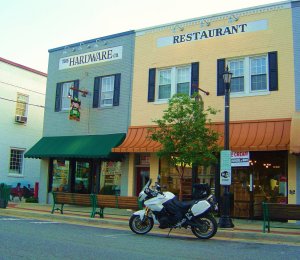
The Hardware Co. Restaurant, Hillsville, VA.

I’ve returned to familiar ground. It was getting late, I hadn’t eaten all day, and I’d planned for this eventuality. I laid out my routes so I’d make a couple passes through Hillsville, VA. It was one of the places I stayed previously on my scouting trips. I knew I’d get a good meal, go back to the same motel, and I’m ready to crash for the evening.

394 miles today. Not all that impressive. A little under 100 were spent on highway or major roads. I did spend some time on gravel roads which slow progress considerably. Easier to go on through than route around them.

More of the day was spent in North Carolina than expected. Due to the reconfiguring of the maps, more of North Carolina is included as I criss-cross the border. I didn’t expect to find as many good roads as I did. Those I thought wouldn’t be suitable proved true. Nonetheless, got to check them all. I still need to revisit some more of North Carolina to compare the roads I’ve discovered to the roads I already know. I should wrap that up in the morning then spend the rest of the time in Virginia. The only fair way to compare them is to ride them all and judge them fresh.

Amazingly, the predicted rain held off. It’s now supposed to move through tonight. That would work out well. It’s a lot hotter than I expected. Should have packed the mesh gear. Hard to relate to the lower altitudes when you live up high. Coming down a couple thousand feet has a big effect.

With luck, I’ll reach Roanoke by tomorrow evening. I’m pretty tired. I’ll get this first map finished up by mid-day and should knock out a good portion of the next. While it would be nice to finish two, I’m not so convinced it’s going to happen. If I get inspired, I brought along the third. For now, I’m sure I’ll get only one.

Wayne@americaridesmaps.com

>> Go To America Rides Maps.com – http://americaridesmaps.com

Virginia Won – Wayne Zero

I thought I had things planned out. The roads told me different. That’s what I get for trying to rush things along.

I had an ambitious schedule. Spend three or four days on the motorcycle finding the best map candidates. The rejects are usually quickly noted. I was hoping to hit two, maybe three maps worth of roads. Find the promising areas not identified from home – there are always undiscovered treasures. Just riding along, pass a road not on the list, and circle back to check it out. Occasionally you find a gem. Most times, you quickly know why it was left off the route list. Serendipity is rare.

Believe it or not it takes up to a week to plan out a map before I do the rides. Even so, the plan changes once I actually experience them. The goal is efficiency but is never achieved. I know ahead of time the majority of the roads I choose to investigate as potential candidates to include on one of my America Rides Maps will be rejected. I’m very selective. Just because a road appears as a wiggly line on the map doesn’t mean it is good enough. There are lots of wiggly roads. Few of them meet my standards. I’m only looking for the best.

Of those few good ones, I need to plan to ride them at least twice. Once in each direction, and at different times of the day. The best roads often see up to four passes. If it’s that good, I like it enough to work it in to my travels again. Revisiting a road is the only way to determine the traffic load. Just because it was devoid of traffic at 11 AM doesn’t mean it stays that way.

Some roads are better in one direction but not the other. Views seen approaching and climbing the mountains are quite different from those leaving. The views are relative to others in the area. All these factors come into play.

Then there’s the arguments with the GPS. She says there are roads where none are visible. Submerged the bike in a river once following her advice. Good thing she’s waterproof. The trout were laughing with her that day. She-devil in a box.

Enough whining? Did I mention the rain that wasn’t supposed to be happening? Both days? Karma. I’ve already logged more than a thousand miles in Virginia and I’ve hardly begun to get a grip on it.

Time to get serious. Back to the drawing board. More time planning. I’ll return next week. This time with the precision of a military invasion. Focus on one small area at a time. Secure it and move on. No need to revisit. At least that’s my new plan. Slow and methodical. You don’t rush a masterpiece. I hope this is one when I’m done.

Wayne@americaridesmaps.com

>> Go To America Rides Maps.comhttp://americaridesmaps.com/

Boston Bans Aftermarket Exhausts – Comments

Photo: Is your bike next?

Discussion has been pretty widespread on the net re: the new law in Boston which bans aftermarket exhausts for motorcycles. Rising above the usual spew regarding such controversial issues I look for insight from within the industry. The issue has been posted on LinkedIn in the Motorcycle Industry Professionals group of which I am a member. http://www.linkedin.com/groupAnswers?viewQuestionAndAnswers&discussionID=4714375&gid=139818&commentID=4747099&trk=view_disc

I posted my opinion as follows which may or may not agree with yours.
It’s the handwriting on the wall guys, something brought upon us by a few who felt their “freedom” to enjoy loud pipes was more important than their freedom to ride in the first place. The city is taking the easy way out – easier and more effective than enforcing noise ordinances. I won’t be surprised to see more of it. Now it’s into the courts to spend the time and expense to try to reverse this before it spreads and comply with it in the mean time. More big brother telling you what you can and cannot do. That’s sad.

Living in a motorcycle tourist destination I deal with this issue first hand. While there are those who welcome the motorcycle tourist and recognize the benefit of them, there are those who despise them for disrupting their solitude. I’m at the Chamber of Commerce meetings as events are opposed and cancelled. I see the “noise ordinance enforced” signs with motorcycle icons on them going up in the small towns. Loud pipes close doors and windows as well as minds.

I realize this rant will followed by others from the “loud pipes save lives crowd”. It always is with all the examples and instances of prior escapes from catastrophe. Your bike already has an audible warning device – it’s the button with the little horn icon on it. If it’s not loud enough, upgrade. It’s cheaper than straight pipes. How long do you think you’d tolerate or be tolerated riding around holding down your horn button? To many, it would be just as annoying as your thumping or screaming exhaust notes.

You want respect? You gotta show respect. Freedom comes with the burden of responsibility. Act irresponsibly and suffer the consequences. We’re faced with a choice – we can either address this problem ourselves or others will impose their solutions on us. At this point the opposition has the upper hand. Choose wisely – your choice is affecting my freedom and impacting my wallet as well as yours.

How far are they from banning motorcycle traffic in the city when this fails? They do it with trucks, no “jake brakes”, routing them around towns, etc. now in many locations. People don’t want to hear them. You may be next.

Wayne@americaridesmaps.com

>> Go To America Rides Maps.comhttp://americaridesmaps.com