Planning Your Motorcycle Vacation Trip – What Will The Weather Be Like?

Photo - Rain clouds swirl over Waynesville, North Carolina

Rain clouds swirl over Waynesville, North Carolina

The weather on your motorcycle vacation trip will probably be better than you think or what the weatherman says, – or not. I swear that guy drinks. I know I would be hitting the old mason jar if I had his job. Predicting the weather in the Smoky Mountains is tough. Sometimes, there’s little question about taking that great ride. When there’s a massive front coming through or some system stalls for a while, you can pretty much go with what’s obvious.

In the Smoky Mountains each little valley has its own weather. It can pour down rain all day in one spot, ride your motorcycle over the hill, and the sun is shining. If I had a dollar for every time they’ve predicted rain and I’ve spent a dry day riding the great roads…

My advice – if there’s any question, get on the bike and go for it and always have some rain gear and a warm jacket or fleece in the bags. The highest elevations, like the Blue Ridge Parkway, see the most intense weather. If something’s going to happen it’s going to happen up high first. Coming down, or staying low when planning your motorcycle rides on the iffy days will often do the trick.

Weather also stalls when it hits the mountains and can’t quite make the climb over them. Try heading in the opposite direction and you can often avoid it. Bottom line, when planning your motorcycle vacation, be ready for anything.

Useful Web Resource:

One of the best resources for weather in North Carolina is Ray’s Weather site -http://www.raysweather.com/

True History – How The Blue Ridge Parkway Was Stolen

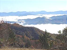
photo - view from Waterrock Knob, one of the highest sections in North Carolina

Morning clouds blanket the valleys in this view from Waterrock Knob in North Carolina

The concept of the Blue Ridge Parkway was to build a scenic connection between Shenandoah National Park in Virginia and Great Smoky Mountains National Park in North Carolina. Even before it was approved by Congress, controversy reigned over the route and clouded the possibility the nations favorite ride would ever be built.

There were strong proponents for building the scenic highway from three states – Virginia, North Carolina, and Tennessee. Originally, they more or less worked together to get the idea launched. Virginia’s route was fairly clear. It would course south from Shenandoah National Park following the highest ridges of the Smoky Mountains. The problem came on which way to go once the border with North Carolina was reached. Great Smoky Mountains National Park is divided right down the middle between Tennessee and North Carolina sharing equal portions in each state. In which state would the parkways southern end of this now classic ride reach Great Smoky Park?

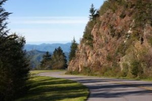
Photo - a view of the Blue Ridge Parkway

Nothing in Tennessee can compare to the views from the North Carolina section of the Blue Ridge Parkway

Tennessee argued the route should be shared between the three states arriving on the north side of Great Smoky Mountains National Park about 40 miles south of Knoxville. North Carolina had different ideas, and a powerful lobby arose from the city of Asheville who wanted the road to pass near it. Reeling from the depression, Asheville felt it’s future relied on tourism and without the parkway, it would would not survive.

Two routes were laid out. North Carolina proposed following the highest passages through the tallest mountains in the east, a route which would not only maximize the views, but come right by Asheville. Tennessee chose a route further north which included both mountains and scenic valleys highlighting various features along the way. It would leave Asheville, the only city of size in the Carolina mountains, in isolation.

Right up to the last minute, it appeared the three state route would prevail. In the end though, it was the powerful and well connected proponents from Asheville who convinced the legislature to favor the route which avoided Tennessee entirely thereby stealing the road from Tennessee.

Riding the parkway it’s easy to see the right choice was made. The highest, most scenic and breathtaking views are found in the North Carolina sections both north and south of Asheville. What a different park we would have now had it been otherwise.

Why Is Riding the Tail of the Dragon at Deals Gap So Dangerous?

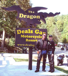
Photo - Smoky Mountain Rider and BMW Girl at the Tail of the Dragon

Smoky Mountain Rider and BMW Girl at the Tail of the Dragon

If you’re convinced the Tail of the Dragon at Deals Gap in North Carolina is “too dangerous” or “ too challenging” a motorcycle ride, you’ve been deluded. If you can negotiate a crowded parking lot without panic, navigate city traffic, or confidently explore unknown back roads, you can ride the “infamous” stretch of US 129 at known as “The Tail of the Dragon”.

While riders are killed on the Dragons Tail almost every year (once you visit you’ll know why) it’s not the road that does them in. It’s a great motorcycle road with more than 300 curves in 11 miles. The pavement is nice, the road is well engineered, and it sees little commercial traffic. Still the motorcycle accidents at Deals Gap keep piling up.

Truth is, motorcycle riders crash here due to their own expectations. The Tail of the Dragon near Deals Gap is so hyped as a challenging and dangerous motorcycle ride people believe they have to make it one. Too many bikers push their limits on this great ride to fulfill the myth and prove something to themselves. Those limits of skill and reason are exceeded far too often resulting in motorcycle wrecks that would not have otherwise occurred had the rider not been so persuaded this was the ideal place to test his mettle. Truth is, I can direct you to roads far more dangerous, all of which make for good motorcycle rides you will enjoy and savor if you don’t consciously try to kill yourself.

That said, the Tail of the Dragon may not be for everyone. If your bike was on the showroom floor last week, and your warm license stills smells like fresh plastic, think twice, break in the tires and get a few miles beneath them. The Blue Ridge Parkway will give you all you need, and I’ve mapped hundreds of miles of other great motorcycle roads in the area.

There are certainly TIMES to avoid the Tail of the Dragon. A rally can turn it into a suicidal circus. Weekends bring out the squids and posers. Safest bet is to go mid week, early in the day. Be warned, it’s heavily patrolled by overworked troopers who have absolutely no sense of humor left.

With hundreds of posted videos to choose from, you can be sure I’ll be posting more. Here’s one of the longer ones that not only shows the entire ride, but demonstrates why this good motorcycle ride has earned such a bad reputation. Is it the really roads fault?

For lots more info about the Tail of the Dragon at Deals Gap visit http://tailofthedragon.com

How Long Does It Take To Ride The Blue Ridge Parkway?

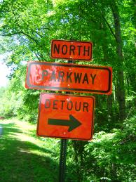
Photo - Detour sign on the Blue Ridge Parkway

It’s not a detour, it’s an opportunity to explore!

10 Hours, 47 minutes, and 27 seconds, so long as you get at least 469 miles from one tank of gas, don’t eat, wear a diaper, and they miraculously resolve all the Blue Ridge Parkway closures and detours. Obviously, that’s not the answer you are looking for.

Riding the Blue Ridge Parkway end-to-end on a motorcycle is a goal for many. It’s our nations classic motorcycle ride. But in planning your motorcycle trip, it is a goal that should be approached like sex – you don’t try to see how fast you can get it done and really enjoy it. Realistically, you could do this great ride in two long days, just to say you’ve done it, but the “I’m an idiot award” would be waiting for you at the end of your scenic ride.

Photo - motorcycle on a Virginia section with caption "Never rush the Parkway - it's meant to be savored".

Never rush the Parkway, it’s meant to be savored.

The more time you put into it, the more pleasure you will get out of your motorcycle vacation. It would be better to focus on exploring small sections of the Blue Ridge Parkway and truly enjoying them. It’s not going anywhere. You can always come back to it. The same spot in the morning is a new experience in the evening, another view with a change of seasons.”

Look at those detours as opportunities to explore the thousands of miles of great roads that surround the Blue Ridge Parkway. The mountains are full of good rides which are devoid of traffic, chock full of scenery, and often more challenging and rewarding to explore.

If you must hurry through, or cover the distance for whatever reason, note those places that were special to you and plan on coming back. The Blue Ridge Parkway is best when you’re not moving at all.

For info about Blue Ridge Parkway Road Closures,
go to http://www.nps.gov/blri/planyourvisit/roadclosures.htm


Wayne Busch - AMERICA RIDES MAPS

Wayne Busch – AMERICA RIDES MAPS

America Rides Maps

Celebrate Blue Ridge Parkway Anniversary 75


Photo - View of the Blue Ridge Parkway from Waterrock Knob overlook

View of the Blue Ridge Parkway from the Waterrock Knob overlook.

2010 kicks off with celebration of our nations most popular national parks 75th anniversary. Construction on the 469 mile long Blue Ridge Parkway scenic road was started in September, 1935 at Cumberland Knob near the border between North Carolina and Virginia (milepost 217.5), though it would take 52 years until the last section was completed in September, 1987 not far from where it all began.

The mission of the Blue Ridge Parkway is to provide a scenic link between two of the easts grandest parks, Shenandoah National Park in Virginia, and Great Smoky Mountains National Park in North Carolina. Inspired by great rides built in the parks of the American west and patterned after earlier scenic roads in the east, the Blue Ridge Parkway was constructed utilizing native materials to emphasize and highlight extraordinary views worthy of national recognition and preservation. In making that link, the Blue Ridge Parkway in some ways eclipsed these other national parks and opened up the isolated and remote areas of the Smoky Mountains for all to enjoy.

Nowadays, more than 18 million people each year come to enjoy the relaxing and inspiring views found along this two lane ribbon of asphalt, more than 1/4 of them on motorcycles. The Blue Ridge Parkway has become our nations most classic ride. What better year to celebrate and enjoy it?

I’ll be highlighting some of those celebrations and relating the often controversial history of one of the best rides anywhere in future posts. Here’s a video to get you started.

For more info about the Blue Ridge Parkway go to http://blueridgeparkway.org

For info about celebrations and events go to http://www.blueridgeparkway75.org/


Planning Your Motorcycle Vacation Trip – Do I Need Reservations?

Photo - Motel sign, motorcycles welcome

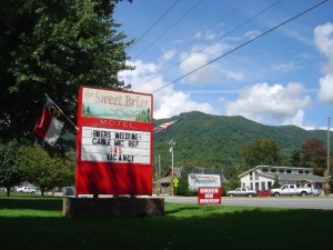
Make sure the Welcome Sign is On for You

If you’re visiting the Smokies on your motorcycle vacation trip during the fall, particularly at peak leaf season, I strongly urge you to plan ahead. Rooms on or near the Blue Ridge Parkway go quickly and people reserve them a year in advance at the popular places.  Even if you don’t want to make reservations now, or only have a general idea of where you might end up, it’s worth doing a little research to be sure your motorcycle vacation plan goes well.

Here’s a tip that may save you some headaches on that motorcycle vacation trip – call ahead to a couple of potential lodgers and ask about room availability during your visit. Just because you checked for motorcycle or Blue Ridge Parkway events doesn’t mean the rooms aren’t all booked for the Wooly Worm festival, the Trout Fest, or some other local folk celebration. Mountain resorts are popular places for conferences and meetings who sometimes try to book rooms when other events are not scheduled. Don’t forget Chambers of Commerce and Visitor Centers (easy to find online) are great resources and will often send you free visitor guides.

A few extra moments planning your motorcycle vacation trip can greatly improve your enjoyment.

Here’s a couple Chamber links you might want –

Great New Motorcycle Road Still Waits Completion

Ahh, fresh tarmac. I wasn’t long into the serpentine climb up the mountain I realized this road was better than I’d expected. It had taken an hour to get here, but then I didn’t take the fastest route. Instead, I took the fun route, revisiting some of my favorite and most enjoyable rides on the southeast course towards Franklin, North Carolina. Taking the highway doesn’t save that much time anyway. There is no direct route from Waynesville to Franklin through the mountains of western North Carolina. There are no direct routes anywhere. That’s what makes it motorcycle heaven. You’re not going to save much time taking the four lane, might as well take the back roads and enjoy the ride.

Photo - A view of Onion Mountain Road

A section of Onion Mountain Road which has been paved.

I’d already accepted the disappointment that Onion Mountain Road was not yet completed having passed the eastern end of it on my way down. I could only afford a quick glance at the junction while keeping focus through the screaming tight descending hairpin curve, but even a brief view was enough to reveal this end was not yet paved. Knee down, bike laid over on the edge of the tires, it was far more important to concentrate on just how much throttle to roll on coming out of the turn before I  jumped to the other side of the motorcycle and laid it into the next curve. I was having way too much fun to circle back, I’d check it out from the other end.

Photo - Where the pavement ends and the road beyond

2.1 miles in the pavement ends but the roadbed has been laid. The remaining portion should see asphalt with warmer spring weather.

Every time I ride through here I find myself thinking I don’t come this way often enough. These roads are stellar in quality,  some of the most challenging found anywhere. There’s rarely anything you could call traffic. Most travelers choose the “main” roads to pass through this rugged area of high peaks and forests leaving the back roads delightfully empty and welcome to enjoy at your own comfortable pace.

I turned west when I reached US 64 the principle east-west route through the area and headed towards Franklin, then turned north on 441 to make my approach to Onion Mountain Road and select the best connections. The detour and construction signs were still up, though obscured by black plastic now that the road was open to traffic again. Another hint the project was still in the works. While I’d hoped to find it completed, the road reports were cryptic in saying the road would be closed for paving until December.  Once the cold weather sets in, the asphalt plants shut down. Come spring, they’ll pull the plastic off the signs and resume work (I hope).

I assume the situation will be similar to the section of NC 281 which was paved last year and is now part of one of my favorite loop rides. They get as much done as they can preparing the roadbed before winter. When things warm enough, it’s fairly quick work to come back and lay down the asphalt. Judging by what they’ve done so far, it’s going to be eagerly awaited. It’s the prep work that takes the time, cutting into the embankments and filling the road, adding culverts and bridges where needed.

Photo - A view from the roadside.

The panoramic views are some of the best found in the area. They should get even better higher up.

Only 6.2 miles long, you might wonder why I’m so excited about this road. It’s isolated from any towns, just a remote section going from nowhere to nowhere else. Once fully paved, it will make a strategic connection between other great rides that will allow you to avoid the traffic on US 64 and open options to link them together, more ways to bypass the four lane highway and town traffic. There’s that, and then there’s the road itself. Making the climb up Onion Mountain is one beautiful arc after another. As you gain altitude the road frequently follows a narrow ridge dropping precipitously on both sides. The views, especially with the leaves off the trees are some of the best panoramic sights in the region.  It will be one of those roads where you pull over and take out the camera to remember it. When coupled with the other fabulous rides in the  surroundings,  it will be one you not only treasure but want to come back to and ride again.

2.1 miles of it are paved, then it abruptly turns to gravel. I didn’t ride it through, though I could see the 4.1 mile section remaining had been prepped. From the end of the paved section it continues to climb up the mountain and I expect the views will get even better. I’ll keep watching it for progress and make another visit in the spring. As soon as it’s ready, I’ll add it to the map of this area with the best connecting roads, probably another 15 miles of great riding for you to enjoy. With luck, it will be climbing the list of classic rides by summer and I’ll be frequenting the area more often.
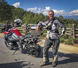

Wayne Busch - AMERICA RIDES MAPS

Wayne Busch – AMERICA RIDES MAPS

Wayne@americaridesmaps.com

>> Go to America Rides Maps.comhttp://americaridesmaps.com

While Mapping Motorcycle Roads I Found the Andrews Geyser

I was passing through Old Fort, North Carolina the other day hoping to find a road I might have missed on one of my motorcycle mapping trips, when I came across the man-made Andrews Geyser. The wading pond was frozen, the spout encased in heavy ice, and the grass surrounding the pool was a huge sheet of bumpy rhyme.

Photo - Andrews Geyser encased in ice near Old Fort, NC

Andrews Geyser encased in ice near Old Fort, NC

The Geyser was built in 1880 as a tourist attraction and to commemorate those whole lost their lives building the railroad that climbed from Old fort to Swannanoa, then on to Asheville. Until that time, Old Fort was as far west as the railroad went. The 3 mile climb through the mountains required more than 12 miles of serpentine track and seven tunnels. More details at  (http://www.romanticasheville.com/old_fort.htm)

My explorations take me to the most unusual and scenic locations as I search out the best roads for my motorcycle maps. I’d passed the sign that directs you to the Geyser on the west end of town many times, but never ventured out to see it as the paved road does not make it all the way through the mountains. It’s a nice ride, but it doesn’t lead you anywhere else so it’s not on my motorcycle map of the area. Still, you won’t miss the signs.

If you’re passing through Old Fort on your way to reach those great two lane mountain roads nearby and have a little extra time, you might want to ride out and see the 80 ft. high plume. I got there late on the day when the temperatures never went much above freezing. Next time I visit, I hope it will be a little warmer.


Wayne Busch - AMERICA RIDES MAPS

Wayne Busch – AMERICA RIDES MAPS

Motorcycle gift – Blue Ridge Parkway Book

Image - book cover from Amazon.com

Book cover image - "borrowed" from Amazon.com listing

With the 75th anniversary of the Blue Ridge Parkway happening this year, our local paper has been running a series of articles on the history of the nations most visited park based on the book by Ann Mitchell Wisnant, ” Super-Scenic Motorway: A Blue Ridge Parkway History“. They’ve been interesting enough that I’ve just ordered a copy from Amazon.com.

 If you’re still looking for gift ideas for the motorcyclist, this would be a great one. I plan to share some of the more interesting tidbits with you once it arrives.

I’ve posted videos with other gift ideas at America Rides Maps.com, and please consider, motorcycle maps make an affordable and appreciated gift for the biker in your life.

Skiing the Blue Ridge Parkway – Not this time

While we had high hopes of a decent snowfall, it wasn’t enough to enjoy skiing on the Blue Ridge Parkway. It’s still a little early in the year for any significant accumulations, and this storm passed north of us dumping most of the white stuff in eastern Tennessee.

Photo - Wayne pauses near the Freein Knob Overlook on skis.

Wayne pauses near the Ferrin Knob overlook on a parkway ski outing.

Here’s a photo from last year, or maybe the year before. Every once and a while things come together just right and the parkway becomes a cross-country ski trail. This time, the snow didn’t stick well enough to build up. We’ll try again with the next snowfall.