Motorcycle Friendly – The Shady Valley Country Store at The Snake

There’s a reason my wife rarely tags along with me while I’m out working from my motorcycle – I only stop for two things, one is fuel. The other can be remedied at any clump of shrubbery. Rarely do I ever stop to eat, drink, or grab photos. It’s all about covering the miles. Those creature comforts can wait until I retire for the evening when darkness makes any further progress futile. I think that’s about to change and one of the first places I’m going to visit is the Shady Valley Country Store the home of “The Snake”.
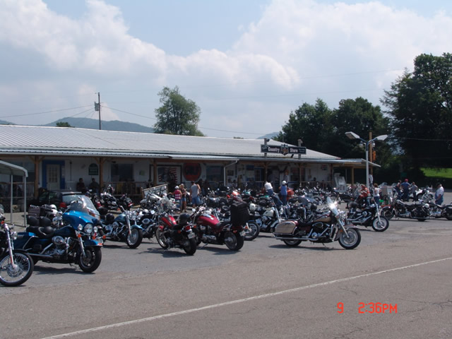
Photo - Shady Valley Country store

Shady Valley Country Store serves thousands of motorcycles weekly who come to ride "The Snake" and surrounding roads.

Located at the junction of NC 133, NC 91 and US 421 (a.k.a. “The Snake”), the Shady Valley Country Store is at the hub of some of the best motorcycle rides found in the Smoky Mountains where North Carolina, Virginia and Tennessee meet. Serving thousands of motorcycles every week, it provides a convenient fuel stop with regular as well as premium “Snake Venom” for your thirsty motorcycle. I’m told the 1/2 lb. black angus burgers, the thick bologna sandwiches and great chili dogs will keep you going full speed as well.

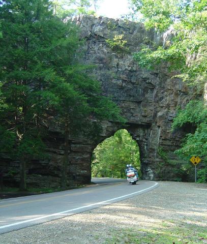
Backbone Rock on TN/NC 133

Backbone Rock on TN/NC 133 not far from the Shady Valley Country Store

I’ve blasted past the Shady Valley Country Store enough times. Next time I’m up there I’m stopping in to check it out, maybe get me a T-shirt or some other Snake memorabilia. Expect to get a first hand report ASAP.

The Shady Valley Country Store

Motorcycle the Blue Ridge Parkway – Sights from the Road – Mabry Mill

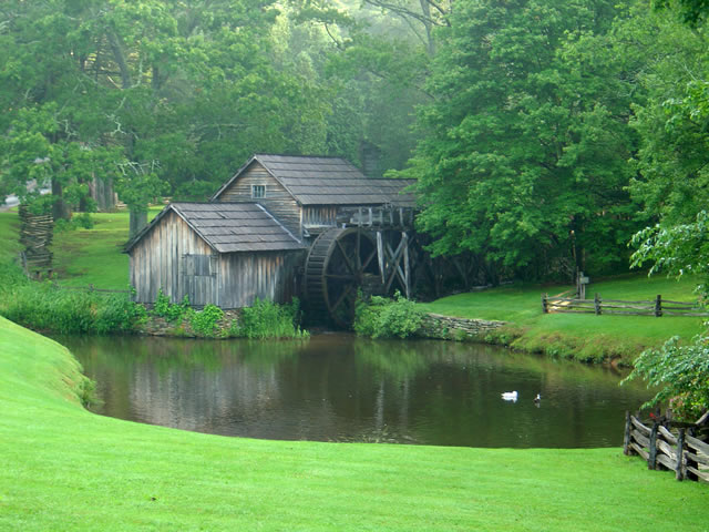
Photo - Mabry Mill on the Blue Ridge Parkway

Mabry Mill – One of the most photographed sights on the Blue Ridge Parkway

One of the most popular and photographed sights on the Blue Ridge Parkway is Mabry Mill. It’s located at milepost 176 in Virginia near Meadows of Dan. Whether you’re motorcycle touring or just cruising along in your car, it’s hard to resist pulling in for a photo and a closer look (and maybe a pancake).

The mill is one of the buildings the National Park Service felt represented the character they wished to portray in their interpretation of Appalachian life and culture. It started as a blacksmith shop, then became a sawmill, then evolved into a grist mill, though it included a lathe, a planer and a jig saw so the versatile Mr. Mabry could maximize it’s use and success.

The mill has been restored and maintained and is still used for occasional demonstrations of it’s workings. The stone ground cornmeal, buckwheat flour, and grits can be enjoyed at the nearby restaurant as pancakes, biscuits, and cakes, along with preserves and country ham from the surrounding area (plan a breakfast here, but come early).

Contrary to what the Park Service originally portrayed about the “isolation and remoteness “ of these “mountain people”, there were thriving communities surrounding the area – a mill does not last long in the middle of nothing. The area surrounding the Blue Ridge Parkway in this section of southern Virginia is laced with an amazing number of fabulous two lane motorcycle rides through historic and scenic countryside. Don’t be afraid to get off the parkway on your motorcycle and enjoy some of these great motorcycle rides.


Wayne Busch - AMERICA RIDES MAPS

Wayne Busch – AMERICA RIDES MAPS

America Rides Maps

Notes from the Road – Eateries, The Hardware Co., Hillsville, VA

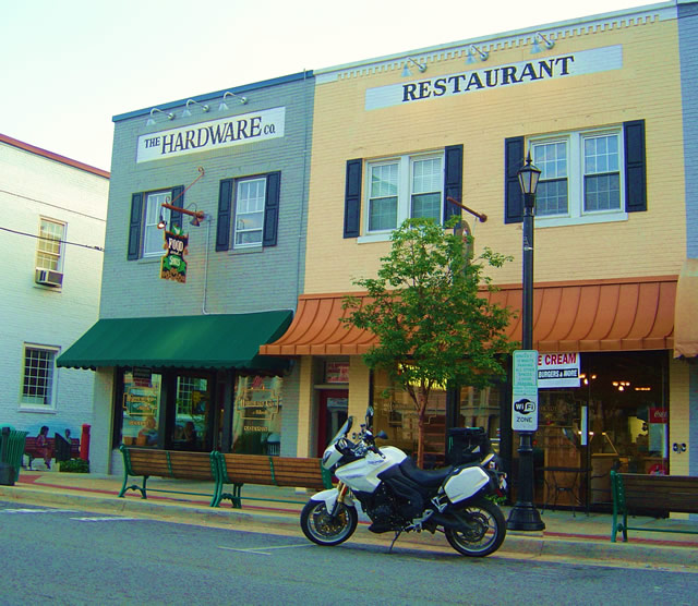
Photo - The Hardware Co. Restaurant, Hillsville, Virginia

Photo - The Hardware Co. Restaurant, Hillsville, Virginia

As I’m out on the road doing the explorations for America Rides motorcycle maps, I try to find good places I can recommend. I visited this one several times and think it’s one you’ll like to visit on your motorcycle vacation. It’s 10 minutes more or less from the Blue Ridge Parkway on VA 52 from the Fancy Gap exit in the southern Virginia town of Hillsville.

While there is a historic section in Hillsville where this restaurant serves as a centerpiece, the town spreads along the main roads which all come together in the small town, including Interstate 77 and US 221. I found myself staying here on several occasions as there are a large number of motels near the Interstate. It makes for a good place to not only lay over on a Blue Ridge Parkway vacation trip, but also to tour the surprising number of great motorcycle rides which course through the surrounding countryside. It became the hub for one of my most extensive maps.

The restaurant resides in a building which was originally a hardware company, hence the name.The food is good, sometimes great. I’ve always enjoyed my meal, a fine compliment to the great rides that lead you here. There’s a nice pub to get a cool one and live music on some evenings. If you’re passing through on a warm day or just looking for a treat, right next door is an old time soda fountain where you can get some pretty darned good ice cream and sodas.

You can check them out online at http://www.hardwarecompany.net/ . The street address is:

The Hardware Co. of Hillsville
508 North Main Street
Hillsville, VA
Telephone: 276-728-265
Email: info@hardwarecompany.net

True History – How The Blue Ridge Parkway Was Stolen

photo - view from Waterrock Knob, one of the highest sections in North Carolina

Morning clouds blanket the valleys in this view from Waterrock Knob in North Carolina

The concept of the Blue Ridge Parkway was to build a scenic connection between Shenandoah National Park in Virginia and Great Smoky Mountains National Park in North Carolina. Even before it was approved by Congress, controversy reigned over the route and clouded the possibility the nations favorite ride would ever be built.

There were strong proponents for building the scenic highway from three states – Virginia, North Carolina, and Tennessee. Originally, they more or less worked together to get the idea launched. Virginia’s route was fairly clear. It would course south from Shenandoah National Park following the highest ridges of the Smoky Mountains. The problem came on which way to go once the border with North Carolina was reached. Great Smoky Mountains National Park is divided right down the middle between Tennessee and North Carolina sharing equal portions in each state. In which state would the parkways southern end of this now classic ride reach Great Smoky Park?

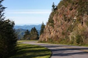
Photo - a view of the Blue Ridge Parkway

Nothing in Tennessee can compare to the views from the North Carolina section of the Blue Ridge Parkway

Tennessee argued the route should be shared between the three states arriving on the north side of Great Smoky Mountains National Park about 40 miles south of Knoxville. North Carolina had different ideas, and a powerful lobby arose from the city of Asheville who wanted the road to pass near it. Reeling from the depression, Asheville felt it’s future relied on tourism and without the parkway, it would would not survive.

Two routes were laid out. North Carolina proposed following the highest passages through the tallest mountains in the east, a route which would not only maximize the views, but come right by Asheville. Tennessee chose a route further north which included both mountains and scenic valleys highlighting various features along the way. It would leave Asheville, the only city of size in the Carolina mountains, in isolation.

Right up to the last minute, it appeared the three state route would prevail. In the end though, it was the powerful and well connected proponents from Asheville who convinced the legislature to favor the route which avoided Tennessee entirely thereby stealing the road from Tennessee.

Riding the parkway it’s easy to see the right choice was made. The highest, most scenic and breathtaking views are found in the North Carolina sections both north and south of Asheville. What a different park we would have now had it been otherwise.

Motorcycle Quote / Photo for the Day

Young riders pick a destination and go… Old riders pick a direction and go.
– Author Unknown.

Photo - Roaring Run Road, Virginia

Roaring Run Road, Virginia – isn’t this what we’re all hoping to find?

Trust your instincts and feelings when exploring and you’ll often be rewarded. I’d passed by this road earlier in the day yet something drew me to circle back later and investigate it. Despite rain and the failing light near the end of the day, I backtracked and was rewarded with one of the most beautiful rides of the trip. It was worth it.

Roaring Run Road in Virginia is just a short ride, a little more than 4 miles long, but it was so nice I stopped for a photo to share with you. It was probably once just a remote and rugged forest road over a ridge, but it had been recently paved with clean smooth asphalt that maintains the curvy character you see here for its length as it follows the course of a mountain stream. It goes from nowhere to nowhere, but it’s the kind of places I’m always looking for.

This road and many others like it are found on America Rides Map “Great Rides Near the Start of the Blue Ridge Parkway in Virginia“.

Motorcycle Quote for Today

“Two-lane blacktop isn’t a highway – it’s an attitude.”
– Author Unknown

Photo - two motorcycles passing beneath Backbone Rock, TN

Two riders approach the tunnel through Backbone Rock, Tennessee


SR 133 is found on America Rides Map “Great Roads Near Boone, Banner Elk, And Blowing Rock“. It’s part of one of my favorite loop rides in the area, a ride which clips the corners of three states – Virginia, North Carolina, and Tennessee. There are sections which rival the infamous “Tail of the Dragon” and a wonderful area to spend time on two wheels.

NEW MAP! – The Roads of Roanoke and Beyond

I’ve just finished the latest map, The Roads of Roanoke and Beyond. It’s the second of the three map Blue Ridge Parkway – Virginia Series and catalogs 90 miles of the Blue Ridge Parkway as well as more than 2 dozen great roads in the surrounding area. There are also more than 20 good “connector roads” which give you shortcuts or the best routes to reach my top rated rides.

It was an exciting moment when I transferred the overlapping data from this newest map to the raw data file of the last map in the series. I’ll be completing it as quickly as I’m able. Once done, America Rides Maps will offer the most comprehensive collection of great rides along the entire 469 mile length of the Blue Ridge Parkway and enough great riding to give you years of motorcycle touring pleasure.

The race is on as fall weather closes in on us. There’s a lot of preparation before I load up and motor north to begin the reconnaisance. Shorter days mean less miles covered and cooler weather will also bring it’s challenges. I need to locate a new base to work out of. There will be challenges, but I’m looking forward to them.

Little time to take a breath or relax, got to keep pushing to get it done. For now, another milestone has been passed.

You Never Know Until You Ride It

I‘m back from my most recent trip mapping Virginia. It was one heck of an expedition averaging more than 500 miles per day on my motorcycle, mostly on two lane back roads. Areas I thought would be really good turned out to have little appeal. The area I thought would largely be a waste of time turned out to be one of the best. You never know until you ride it, that’s why I do what I do.

I revisited some sections on the last map which overlap into this one which revealed previous roads connected to fabulous new roads. I’ll be making some minor changes to “
North Carolina / Virginia Border Rides” to reflect these new discoveries. There are some outstanding rides you really shouldn’t miss which cross the borders of these two maps.

The central point of this second Virginia map is the city of Roanoke. The
Blue Ridge Parkway cuts through the heart of the map touching on the very edges of the city. I explored a few roads close in to the city. While most of us don’t get on the bike to ride the urban landscape, should you be staying near, there are a couple rides in close you may want to do to catch a nice view or a sunset from up high. Surprisingly few paved roads connect to the Blue Ridge Parkway on this map, so knowing where they are and which way the closest gas station is will be helpful.

The highest ridges of the mountains and the Blue Ridge Parkway run in close to the city. The character of them changes as you move north leaving the rolling hills of southern Virginia behind to enter the more mountainous and scenic peaks north of the city. Roads to the south side quickly entered rolling but relatively flat country and while there are more roads, I found fewer and fewer of them engaging me and making me want to come back and ride them again. I have a lot to eliminate based on this reconnaissance.
On the other hand, north of the city is the place I enjoyed most. Here the various mountain ranges are distinct, separated by long valleys. The roads which run through these long vallies are far more curvy than they appear on a map and some of the views are wonderful. Be warned though, I’m going to try to describe some of these roads as “adventure” roads. Some will like them better than others.
As I ripped along them on a bike built for this kind of terrain, bouncy, tight, sometimes technical in demeanor, I thought about what it would be like riding shotgun on a big cruiser, fully loaded, doing more hanging on than enjoying the beautiful scenery. I think your passenger might find the experience a bit demanding if done at a hurried pace. I’ll try to identify these roads for you. On the other hand, at a relaxed pace and with the camera handy, I felt like I was riding through a national park at times. I can’t help but recommend them.

There’s one more map to go in this series to fully cover the entire range of the Blue Ridge Parkway and the surrounding areas. I’ll do my best to crank this one out by the end of the week. For the first time this year I plugged in my heated gear and really needed it as I climbed the high passes from Tennessee into North Carolina on the midnight ride home. It’s going to be regular kit from now on. I have once again paused on the West Virginia border and stared into what looks like the promised land. I’m pretty sure I know where the sequel to these maps will lie.

Wayne@americaridesmaps.com

>> Go To America Rides Maps.com http://americaridesmaps.com

Broke My Motorcycle – Again

The Triumph Tiger 1050 is often referred to as an “adventure bike” – a motorcycle that does most things very well and will go almost anywhere though in it’s most recent iteration it is far more biased towards the road than previous incarnations. I have taken that “adventure” heritage to extremes – I’ve laid it down at highway speeds on the Interstate, ridden it through deserts, floods, and snow, and once completely submerged it in a river. All these things it has shaken off like a wet dog after a cold swim, though it has accumulated a collection of scrapes, scratches, and minor blemishes that tell the story of it’s travels. Only a close inspection reveals them and amazingly few parts have ever broken. They are proudly worn like badges of honor boasting the invincibility built into this machine.

Well, I’ve broken it again, and it looks like I may have to pay the dues for exploring the boundaries of good sense. This time, it was mapping Virginia that led to the minor calamity. My stubborn intensity to actually ride and explore every potential road in an area to often leads me to places no reasonable person would consider, and this was another one of those foolhardy ventures.
I’d already lost more than an hour due to blinding rain and fog so thick you couldn’t see across a two lane road. First sipping coffe in an empty greasy spoon, then near the parking lot sitting on a wet rock waiting for the ability to make out where I was going. When I could finally see the repair shop across the street, I set out.
The detour and road closed signs should have put me off. Still, I pressed onward, determined to discover if this was a temporary situation that required monitoring or something more permanent. While this road did not show much promise from the research, it did have a section that looked interesting and I leave no stone unturned. Nor did I want to retrace my route. The road was leading into the area I’d be working that day and in the interest of saving time I was determined to ride through whatever to get there and maximize my efficiency.
I should have turned back when I reached the bridge. Blocked with huge concrete barriers and orange warning signs, it spanned a deep gulch over a railroad track. I stopped to ponder the situation closer to discover a narrow pathway weaving between the barriers. I walked out on the bridge, the pavement and concrete irregular and broken, and jumped up and down vigorously to test it’s soundness. The road on the far side led out into the farmlands. I could do this.

I returned to the bike, mounted, and quietly motored towards the slot skirting the very edge of the drop into the gulch. Approaching with cautious hesitation through the tall wet weeds, the bike suddenly lurched to a stop as the front wheel found an unseen mound of pavement hidden in the greenery and began to topple. With all my strength I wrestled it away from the drop and eased back. A timid approach was not going to get the job done.

I took a moment to summon my resolve, studied the line I would follow, focused on the point I would emerge, and released the clutch with a measured amount of throttle open. The front wheel rushed forward, bounded over the obstacle, and passed through the gap dead center just as planned. Unfortunately, the rear wheel was not quite on the same path and as it encountered the hump it slipped and skirted violently towards the slope. As momentum carried me trough, a loud SNAP occurred and while I slowed to a stop half way across the bridge my left luggage case spun along on the pavement beside me. When the bike leaned, it had caught on the edge of a barrier and broken off.

I parked the bike and retrieved the case as well as the bits of broken mounting brackets. Designed to quickly attach and detach with a simple key lock, most of these clamps were now broken. Still, one was intact and I remounted it on the bike and locked it in place. Somehow, there was enough left to hold it there, though it was anything but secure.
I carefully threaded through the barriers on the far side of the bridge and kept one hand reaching back to insure the case was still there as I proceeded down the road. As expected, this next section of road was uninteresting but the promising part lay ahead. The case stayed in place as I crossed the countryside. I watched the GPS as the curvy parts drew ever closer. My heart sank as I reached it passing a sign that indicated unpaved road ahead.

The next 12 miles or so was a bumpy gravel forest road, steep and twisty as it threaded through the trees and rocks of some obscure Virginia hilltop. My hand kept flashing back to confirm the case was still attached with every rough climb or big rock crossed. Were it to come off here, it would tumble down some steep slope and both the case and contents would likely be lost. It was still there as I emerged on the back side of a bleak and impoverished factory town, the umber brick relics of long abandoned mills and plants overgrown with weeds and rust, windows broken, once bustling factories now silent and abandoned to time.

Things did improve, and I covered a lot of miles through the rest of the day. Periodically, I put my hand behind me to feel the case still loose, but in place, and it remained there until I got home. I’d hoped to somehow drill, screw, and glue things back together, but it’s hopeless. I’m going to need to buy a new side case. For the first time, I returned to my maps and completely removed any trace of that road. I don’t want any chance you’ll follow in my tire tracks. There are far better roads to ride.


Wayne Busch - AMERICA RIDES MAPS

Wayne Busch – AMERICA RIDES MAPS

Wayne@americaridesmaps.com

>> Go To America Rides Maps.comhttp://americaridesmaps.com

Scenic Motorcycle Rides – Backbone Rock, TN

photo - motorcycle cruises through Backbone RockI went back to Virginia this weekend to revisit and explore some of the sights I’d passed while mapping the area

I’m pretty much all business when mapping – I only stop for three things; gas, to take notes, and when “nature” forces me to do so. Eating is a luxury typically left for the evening to make the most of the time on the road. This trip was to go back and savor some of the gems I’d just blown by previously.

One of my favorite loop rides is found near the point where North Carolina, Virginia, and Tennessee meet, a 103 mile jaunt that takes you on some of the twistiest and most scenic roads. It’s listed on America Rides Map #4 – “Great Roads Near Boone, Banner Elk, and Blowing Rock.

Heading south from Damascus, Virginia, on SR 133, you soon enter the National Forest in Tennessee and signs for Backbone Rock Park start appearing along the road. Round a curve and you find yourself zipping through the quick yet dramatic tunnel through Backbone Rock.

I stopped in to investigate.

The Empire Mining Company blasted through Backbone Rock in 1901 to lay train tracks for the Tennessee Lumber Company. Long gone, the rail bed became the roadbed which continues on towards Mountain City.

The ridge is about 75 feet high and 20 feet thick, though it narrows near the top. There is a steep trail from the parking area on the right just after you pass through the rock, though if you have any aversion to heights and walking near the edge of a cliff, you’ll never make it to the section of rock which straddles the road.

There are several hiking trails, picnic tables and campsites, a waterfall is about 0.4 miles on a foot trail. The area is popular for fishing and kayaking.

_______________________________________________________________________________

Wayne Busch

Wayne Busch - Cartographer

Total Rider Tech Logo

Learn Total Control

– Wayne Busch lives in Waynesville, NC, where he produces the most detailed and comprehensive and up-to-date motorcycle pocket maps of the Blue Ridge and Smoky Mountains to help you get the most of your vacation experience. See them here – AmericaRidesMaps.com

Wayne is an advanced motorcycle instructor for Total Rider Tech teaching Lee Parks Total Control Advanced Rider Courses. It’s time you looked into advanced rider training to ride more confidently and safely, it will change your mountain riding experience. It worked so well for me I became an instructor! Total Rider Tech

America Rides Map #4 – “Great Roads Near Boone, Banner Elk, and Blowing Rock

_______________________________________________________________________________