Fun Motorcycle Rides in Georgia from The Lodge at Copperhead

Fun Motorcycle Rides in Georgia from The Lodge at Copperhead –

Fun motorcycle rides in Georgia GA 348

Fun motorcycle rides in Georgia GA 348 – a couple of the riders who tagged along on the Fun Ride out of The Lodge at Copperhead

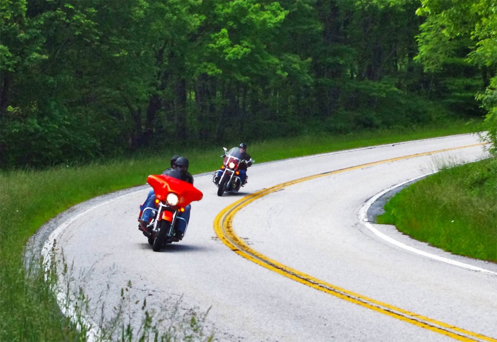
A couple photos from the last “fun ride” out of The Lodge at Copperhead in Blairsville. The Lodge at Copperhead is the southern gateway to the Blue Ridge Mountains and the fantastic riding begins at their doorstep.

Fun Motorcycle Rides in Georgia-leaving the Lodge at Copperhead

Fun Motorcycle Rides in Georgia – getting ready to head out with half a dozen bikes to ride the back roads of Georgia’s Blue Ridge Mountains

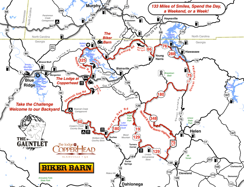
Literally leave the front gate of The Lodge at Copperhead and you’re on The Gauntlet motorcycle ride, a fantastic sampling of the great motorcycle roads that draw bikers from all around.


Fun Motorcycle Rides in Georgia - Get a free map of The Gauntlet at the Biker Barn on US 129 near Blairsville.

Fun Motorcycle Rides in Georgia – Get a free map of The Gauntlet at the Biker Barn on US 129 near Blairsville.

Get your free map at the Biker Barn and get the most out of your ride!

“Fun Rides” are free, just a chance to get out with others and ride some of the best roads in the area. No guides, no rules, they happen on the fly and are usually full of adventures. I always try to throw in a few roads you might never see otherwise.

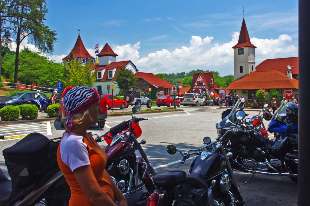
Fun Motorcycle Rides in Georgia - Helen

Fun Motorcycle Rides in Georgia – Helen, Georgia, a German Alps themed town, is a popular stop for both bikers and the masses of other tourists

Fun Motorcycle Rides in Georgia - The Lodge at Copperhead

Fun Motorcycle Rides in Georgia – The Lodge at Copperhead

Next fun ride will be in Maggie Valley or Asheville, NC – I’m making arrangements now. Sign up for the short monthly newsletter if you want to know about the next opportunity. Use this link to sign up now – http://americaridesmaps.com/signupform.html

__________________________________________________________________

Wayne Busch

Wayne Busch – Cartographer

Total Rider Tech Logo

Learn Total Control

– Wayne Busch lives in Waynesville, NC, where he produces the most detailed and comprehensive and up-to-date motorcycle pocket maps of the Blue Ridge and Smoky Mountains to help you get the most of your vacation experience. See them here – AmericaRidesMaps.com

Wayne is an advanced motorcycle instructor for Total Rider Tech teaching Lee Parks Total Control Advanced Rider Courses. Isn’t it time you looked into advanced rider training to ride more confidently and safely? It can transform your mountain riding experience.  Total Rider Tech

____________________________________________________________________

100 Best Motorcycle Rides in the Smoky Mountains

Motorcycle Map – Best Motorcycle Rides in the Smoky Mountains

America Rides Maps announces its first large format motorcycle ride map. Available in 24 x 36 inch and 31 x 48 sizes.

Image of map the Best Motorcycle Rides in the Smoky Mountains

Image of map the Best Motorcycle Rides in the Smoky Mountains - B&W version. Click for a closer look at all the detail!

The only map of its kind, The Best Motorcycle Rides in the Smoky Mountains highlights more than 100 of the best motorcycle rides and more than 50 good connecting roads to tie them all together into endless loops and touring routes.

This map is produced in Black & White  so YOU CAN CUSTOMIZE IT to fit your needs. Use colored markers to highlight where you’ve been or lay out where you want to go.

Santa - great gift ideaPlaning your motorcycle vacation trip has never been easier!

Hang it on the wall to show all the places you’ve been on your motorcycle vacation tours.

Got a favorite place to stay in the Smokies? Discover all the hidden riding nearby. Make the best use of your riding time, ride on on all the best roads,  avoid traffic and congestion.

$24.99 price includes free shipping and handling – First Class US Mail – average 2-3 day delivery. Ships unfolded.

Read more and order here: 

 The Best Motorcycle Rides in the Smoky Mountains

http://shop.americaridesmaps.com/The-Great-Motorcycle-Rides-of-the-Smoky-Mountains-BW-NC023BW.htm

Curious? Need more info? Email info@americaridesmaps.com

_______________________________________________________________________________

Wayne Busch

Wayne Busch - Cartographer

– Wayne Busch lives in Waynesville, NC, where he produces the most detailed and comprehensive and up-to-date motorcycle pocket maps of the Blue Ridge and Smoky Mountains to help you get the most of your vacation experience. See them here – AmericaRidesMaps.com
 

Updates to Blue Ridge Motorcycle Ride Maps

America-Rides-Maps-Logo

www.AmericaRidesMaps.com

First of all, none of the recent updates are significant enough for you to order fresh versions of your America Rides Maps Blue Ridge and Smoky Mountain motorcycle maps if you’ve recently purchased them. The major updates were completed over the last 18 months, and only if your maps are more than a year old will you see the benefit of looking to the newer expanded versions.

However, there have been some more recent changes I’d like to share with you so you don’t miss out on the best motorcycle rides in the Blue Ridge and Smoky Mountians.


image-Georgia-motorcycle-map-cover

#9 - The Best Rides in the North Georgia Mountains

Map #9 – The Best Rides in the North Georgia Mountains was the last completed so it’s most up to date. I’ve just added the new Wolfpen Gap Country Store which will open Saturday in Suches, Georgia (the offical opening is Oct. 1). This is a significant development in Georgia as the convenience store and gas station has long been a popular gathering and rest stop at the intersection of some of the best motorcycle rides in Georgia.


image-motorcycle-ride-map-cover

#6 - The Best Motorcycle Rides EAST of Great Smoky Mountains National Park

Map #6 – The Best Motorcycle Rides EAST of Great Smoky Mountains National Park – This is one of the best of all the maps and were I forced to choose it would be probably be my favorite. It includes the best section of the Blue Ridge Parkway. The gas station and convenience store closest to the Blue Ridge Motorcycle Campground has closed and has been removed from the map. Just a few miles further down the road there are 3 gas stations in Bethel, 2 popular restaurants, so it’s no big deal. I’ve added Max Thompson Rd as a good connector as it’s a way to divert around tiny Bethel and a nice connecting road, and it also intersects the short section of NC 215 (Sonoma Rd) at NC 110. Rather than wait at the traffic light, you can just pass by it on Max Thompson Rd and enjoy this short but twisty ride to reach US 276.


Image-motorcycle-ride-map-cover

#4 Great Roads Near Boone, Banner Elk, and Blowing Rock

Map #4 – Great Roads Near Boone, Banner Elk, and Blowing Rock – I’ve added Shulls Farm / Shull’s Mill Rd which connect NC 105 to the Blue Ridge Parkway in Julian Prince State Park near the Moses Cone House. While I’ve known about this wonderfully twisty ride previously, it somehow got left off the last update. That’s been corrected. I also added the BP station near 7 Devils on NC 105. Again, don’t know why it got missed, I stop there all the time.


image-virigina-motorcycle-ride-map

#1 The Best Rides near the Start of the Blue Ridge Parkway in Virginia

Map #1 – Great Rides Near the Start of the Blue Ridge Parkway in Virginia – I’ve added Red Hill Rd, Plank Rd, and Padgett Hill Rd as good connectors. These make the ride from Natural Bridge to Lexington much more enjoyable then the alternative – Interstate 81. They are not lined with outstanding scenery, and a little remote, but they do the job and throw in a few nice curves along the way.


People have often told me my maps are more up-to-date than their GPS, and I can concur as I use GPS while out mapping – the little lady often gets confused when it comes to the twisty two lane back roads we love so much. I’m constantly updating the maps to keep them as accurate and useful as possible and unlike other maps, I produce them in small batches as they change so often. I want to insure you always get the most recent and up-to-date versions. I hope these changes help you have the best motorcycle rides and get the most out of your precious motorcycle vacation adventures.


Map #1 – Great Rides Near the Start of the Blue Ridge Parkway in Virginia
Map #4 – Great Roads Near Boone, Banner Elk, and Blowing Rock
Map #6 – The Best Motorcycle Rides EAST of Great Smoky Mountains National Park
Map #9 – The Best Rides in the North Georgia Mountains

Wayne Busch

Wayne Busch - Cartographer

Thanks,

Wayne

www.AmericaRidesMaps.com

Last Motorcycle Map of Blue Ridge Parkway Ride Done

711.5 miles. New one day record for a mapping expedition. A good chunk of that was on the Interstate though, so it doesn’t really count. Still, that’s a pretty good haul for the shorter days of the fall season when I typically average less than 500 miles per day evaluating two lane mountain back roads to find the best ones for my maps.

It had been raining since first light though never heavy enough to penetrate my gear and soak me through. Although the weather was fairly warm, my electric heated gear helped dry out any seepage. It was an effective tactic which helped keep me toasty warm even with a little dampness. Must give a plug to Gerbing heated motorcycle gear and Fieldshear outwear. 16 hours in the rain and I remained warm, dry, and comfortable.

As darkness came over me and the last of the two lane roads I wanted to explore passed beneath my wheels, I couldn’t justify another night in a motel at peak season prices. Within reach of Roanoke , I-81 was calling me. The daylight was spent making a huge arc from Staunton, east to the Blue Ridge Parkway, south to the outskirts of Lynchburg, and then west across the West Virginia state line on what were mostly disappointing roads. The least likely prospects are left to wrap up the end of a trip, though some jewels were discovered.

Rolling out onto the dark highway the torrents came in waves and any thought of wet clothing was overshadowed by simply trying to see through the squalls kicked up by semi trucks and a smokey visor better suited to bright sunlight than night cruising. At times the best course was to simply lock on the glowing red pair of taillights ahead and follow them wherever they went as the road disappeared in the glare of headlights reflecting on the rain-fogged helmet shield, playing havoc with any detail of lane lines or signage. The worst of it was crossing the mile high mountain pass from Tennessee into North Carolina when the winds kicked up and the midnight darkness was illuminated only once by the flashing blue lights of a string of troopers gathered to work an accident. Without a car to follow I could have easily driven up one of those runaway truck ramps in the blackness of the storm.

So what did I discover? Fewer great roads than expected. It had been a while since I last came this far north on the Blue Ridge Parkway, all the way to it’s end. I did hit it at pretty much the peak of color, and the days prior had been clear and sunny so I could fully enjoy the fall splendor. The trees were putting on a great show, but I am a harsh judge, spoiled by living near the best section of the 469 mile national roadway.

There are a wealth of rocky outcroppings and the occasional long range view. To the east, you are often treated to views looking out over the vast expanse of the Piedmont stretching to the horizon. To the west, you overlook the southern end of the Shenandoah Valley. The mountains here are distinctly separated by broad valleys which make them stand out in contrast to the flatter portions between them. Elevations are lower than near my home base, and the foliage reflects that. More oak and scrub which tends to turn yellow-orange-gold then quickly brown. Occasional bursts of red, but lacking the evergreens, birch, dogwood, and beech, found at higher altitudes to give a full rainbow of hues. Much or the roadway is through forested patches and the overlooks are less dramatic – they frequently highlight streams which course close to the road instead of the more impressive scenery found south. It’s not that it’s not a worthy ride and full of enjoyment, just not as eye-catching as what I am used to seeing. There’s no place like home.

The really dramatic views are found off the parkway, often to the west as the mountains rise again into West Virginia. The roads through the valleys do have an appeal. Rural, farms and dairy pastures, and lots of historic tiny towns, their relevance lost to time. For those with an historic bent, viewing them is rewarding. I appreciate old homes, and they are found in both pristine preservation and admirable depreciation. In general though, these valley roads offer nothing special, though I did find a few exceptions.

Roads connecting to the Blue Ridge Parkway, typically a good location to find great rides, are disappointingly short due to the lower altitudes. Once the descent is made they either empty into towns or connect to unremarkable valley byways. Again, I noted the best of these.
The most interesting areas are found west where the mountains start to rise again. There are still valleys between them, but roads which cross the ridges can be fantastic. The closer you draw to the West Virginia state border, the more likely you’ll find enjoyable riding. It confirms my desire to expand my travels into West Virginia and explore the border area in more depth.

This trip provides the information to complete the last map in the Blue Ridge Parkway series which means I now offer full coverage of every great ride adjacent to the park from end to end, locations of reliable gas stations, and suggestions to make a trip down that roadway a lot more interesting and enjoyable. It shouldn’t take long to put it together as much of the work was completed before I left. First, a day of rest. Expect the newest America Rides Map this week.
NEW MAP! – The Roads of Roanoke and Beyond

I’ve just finished the latest map, The Roads of Roanoke and Beyond. It’s the second of the three map Blue Ridge Parkway – Virginia Series and catalogs 90 miles of the Blue Ridge Parkway as well as more than 2 dozen great roads in the surrounding area. There are also more than 20 good “connector roads” which give you shortcuts or the best routes to reach my top rated rides.

It was an exciting moment when I transferred the overlapping data from this newest map to the raw data file of the last map in the series. I’ll be completing it as quickly as I’m able. Once done, America Rides Maps will offer the most comprehensive collection of great rides along the entire 469 mile length of the Blue Ridge Parkway and enough great riding to give you years of motorcycle touring pleasure.

The race is on as fall weather closes in on us. There’s a lot of preparation before I load up and motor north to begin the reconnaisance. Shorter days mean less miles covered and cooler weather will also bring it’s challenges. I need to locate a new base to work out of. There will be challenges, but I’m looking forward to them.

Little time to take a breath or relax, got to keep pushing to get it done. For now, another milestone has been passed.

New Features From America Rides Maps

I’ve added two new features to America Rides Maps to give you better service.

The first is a subscription newsletter. If you’re like me, you inbox is overfilled with unsolicited postings. You know the routine – open the mailbox then go down the list – delete, delete, delete, sifting through for something relevant. It gets old. While that kind of promotion may work for some, I really don’t want to be part of it. Still, I have info I think you need and will find useful and beneficial, not to mention I’m offering bonuses and discounts to subscribers. Your time is worth something.

I’ve chosen to use a subscription newsletter where you sign up if you’re interested and you can opt out if it doesn’t suit you. Receive occasional updates that let you know when new maps are released, changes or upgrades are made to current maps, receive subscriber discounts, inform you of road closures and other pertinent travel info, and receive a brief newsletter (more or less monthly) that keeps you informed of what’s happening in the mountains.

The first newsletter went out September 1. It included news of the release of my newest map, North Carolina / Virginia Border Rides, a blurb about the prior release of 5 Classic Rides Around Maggie Valley, updates to a couple of other maps, news of a great new road that was recently paved and another that is currently being improved, first hand reports of the repairs on the Blue Ridge Parkway, an update on the work in Great Smoky Mountains National Park, several articles on The Tail of the Dragon, a discount coupon for subscribers, and more. Click here to sign up for your copy!

The second feature I’ve just added is a Forum. While I enjoy chatting with you on the phone and corresponding via email, I believe I may be able to save you some time (and a phone call) by posting information you need online. The America Rides Maps Forum is located at http://americaridesmaps.eamped.com/ I’m just one guy, and I’m not always available by phone (I don’t answer it when I’m on the bike). This gives you the opportunity to not only post questions, but get input from others who may have pertinent information that can make your trip better. It’s also a chance for you to post info, share photos, tell of your travels, and learn from others who have been places you may not have visited.

The America Rides Maps Forum is brand spanking new, I’m still getting it set up – determining the categories and such. Some of that will be sorted according to the types of postings that come in. At the moment, I am the sole and lonely member, but that will change shortly. This is your invitation to join the discussions.

I expect these new services will help you get more out of your next visit to enjoy the thousands of miles of fabulous undiscovered two lane back roads that America Rides Maps will lead you to. Please take a moment to look at them. I think it’s worth your time.

Thanks,

Wayne@americaridesmaps.com

>> Go To America Rides Maps.com http://americaridesmaps.com

More Blue Ridge Parkway Updates

A few more updates on the Blue Ride Parkway to be aware of;

The Park Service is planning to repave and repair parking lots between milepost 359.7 and 375.1 through December 2010. The work includes the Craggy Gardens visitors center and the Craggy Gardens picnic area and six additional overlooks. There will be occasional closures of the overlooks and traffic will be reduced to one lane during some repairs.

These closures are currently listed at the Blue Ridge Parkway web site:
http://www.nps.gov/blri/planyourvisit/roadclosures.htm

Milepost 269.8 – 280.9 – Blowing Rock Area

Roadway fill repair at Milepost 270.3 will close the Parkway until November, 2009.
For southbound traffic, exit the Parkway at Phillips Gap (Milepost 269.8) to Phillips Gap Road (NC 1168) to Idlewild Road (NC 1003) to US 221 south to US 421 south back to the Parkway at Deep Gap (Milepost 276.4).

For northbound traffic, exit the Parkway at Parkway School (Milepost 280.9) to Old US 421 south to New US 421 south to US 221 north to Idlewild Road (NC 1003) to Phillips Gap Road (NC 1168) back to the Parkway at Phillips Gap (Milepost 269.8).

Milepost 285.5 to 291.8 – Blowing Rock Area

Goshen Creek Bridge repair has closed the Parkway between US Route 421 east of Boone, NC and US Route 321 south of Boone. The detour will begin for visitors traveling south at milepost 285.5, Bamboo Gap. Visitors will follow state road (SR) 1514 Bamboo Road to Deerfield Road, following the detour signs along US Route 321 south of Boone then connecting back to the Parkway at milepost 291.8.

Visitors traveling north will begin the detour at milepost 291.8, intersection US Route 321; follow the detour signs along US321 to state route 1514 Deerfield Road to Bamboo Road which will bring them back to the Parkway at milepost 285.5. The total detour is estimated to be approximately 8 miles. Bridge repair is anticipated to be complete by late spring 2009.

These closures have been posted for a while and are relatively short compared to the closure that detoured around the slide near Mt. Mitchell. I plan to revisit the area soon and will get first hand info on the detours. If there are better ways to go (there often are) I will suggest them.