Blue Ridge Parkway Construction – Plan on Letting the Motorcycle Cool for a While

With the new paving done, I’ve been using the Blue Ridge Parkway more often for my motorcycle touring rides north. It’s actually about as quick as taking any other route if you’re heading for areas between Asheville and Boone, NC, and even if it takes a tad longer, it’s usually so much nicer to go that way. Today though, I hit it at the wrong time.

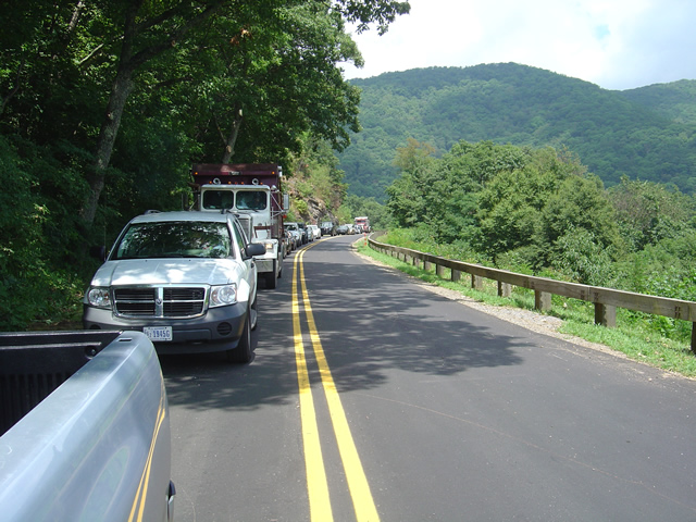
Photo - line of cars on the Blue Ridge Parkway

This line of cars much have stretched for a mile waiting on the tree clearing crews to let us pass.

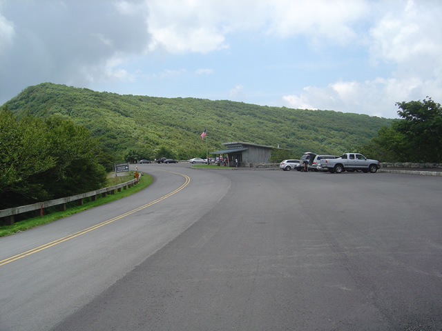
I needed to make a run up to Craggy Gardens for a photo. If you’ve been to Craggy Gardens on your motorcycle vacation you know why it makes a good photo spot, if not, I can be confident you’ll stop there if you pass that way and take your own. It’s the first Visitor Center location north of Asheville, though it’s the views people come for, not the facilities.

I had expected the traffic from the work crews would be tapering off. I was proven wrong today and I’ll need to explore a bit further to find out why.  I just plain didn’t have the time this morning.  As soon as I got on the Blue Ridge Parkway in Asheville I found myself behind a dump truck. I was shortly joined by a string of motorcycle riders as we putted along behind said truck for creeping uphill mile after mile. Just as the truck managed to pick up speed it caught up to another.

Photo - the Craggy Gardens Visitor Center on the Blue Ridge Parkway. Lots of parking, it's a popular stop.

The Craggy Gardens Visitor Center on the Blue Ridge Parkway

I don’t know where the trucks were headed, the last work I saw was near Mt. Mitchell State Park. If they are working on the stretch of road north of there, more power to them and I have no complaints. It needs some attention, though not as severely as that south of Craggy Gardens. The hold up today was the tree clearing crews. I waited for 1/2 and hour to pass. Must be the same slow crews which worked through Asheville last week.
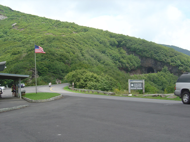
Photo - The Craggy Pinnacle Tunnel

I was looking for and got a nice photo at the Craggy Pinnacle Tunnel for a new "The Best Rides North and South of Asheville, NC" map cover.

Anyway, be aware there are still delays through this section and take it in stride on your motorcycle vacation plans. Spend a little more time at the overlooks, appreciate the improvements to the road, and remember there are  few places better to have to pause and wait. I’ll be at the north end of the Parkway in Virginia next week to update what’s going on there.

_______________________________________________________________________________

Wayne Busch

Wayne Busch - Cartographer


– Wayne Busch lives in Waynesville, NC, where he produces the most detailed and comprehensive and up-to-date motorcycle pocket maps of the Blue Ridge and Smoky Mountains to help you get the most of your vacation experience. See them here – AmericaRidesMaps.com


Scenic Motorcycle Rides – Backbone Rock, TN

photo - motorcycle cruises through Backbone RockI went back to Virginia this weekend to revisit and explore some of the sights I’d passed while mapping the area

I’m pretty much all business when mapping – I only stop for three things; gas, to take notes, and when “nature” forces me to do so. Eating is a luxury typically left for the evening to make the most of the time on the road. This trip was to go back and savor some of the gems I’d just blown by previously.

One of my favorite loop rides is found near the point where North Carolina, Virginia, and Tennessee meet, a 103 mile jaunt that takes you on some of the twistiest and most scenic roads. It’s listed on America Rides Map #4 – “Great Roads Near Boone, Banner Elk, and Blowing Rock.

Heading south from Damascus, Virginia, on SR 133, you soon enter the National Forest in Tennessee and signs for Backbone Rock Park start appearing along the road. Round a curve and you find yourself zipping through the quick yet dramatic tunnel through Backbone Rock.

I stopped in to investigate.

The Empire Mining Company blasted through Backbone Rock in 1901 to lay train tracks for the Tennessee Lumber Company. Long gone, the rail bed became the roadbed which continues on towards Mountain City.

The ridge is about 75 feet high and 20 feet thick, though it narrows near the top. There is a steep trail from the parking area on the right just after you pass through the rock, though if you have any aversion to heights and walking near the edge of a cliff, you’ll never make it to the section of rock which straddles the road.

There are several hiking trails, picnic tables and campsites, a waterfall is about 0.4 miles on a foot trail. The area is popular for fishing and kayaking.

_______________________________________________________________________________

Wayne Busch

Wayne Busch - Cartographer

Total Rider Tech Logo

Learn Total Control

– Wayne Busch lives in Waynesville, NC, where he produces the most detailed and comprehensive and up-to-date motorcycle pocket maps of the Blue Ridge and Smoky Mountains to help you get the most of your vacation experience. See them here – AmericaRidesMaps.com
Wayne is an advanced motorcycle instructor for Total Rider Tech teaching Lee Parks Total Control Advanced Rider Courses. It’s time you looked into advanced rider training to ride more confidently and safely, it will change your mountain riding experience. It worked so well for me I became an instructor! Total Rider Tech

America Rides Map #4 – “Great Roads Near Boone, Banner Elk, and Blowing Rock

_______________________________________________________________________________

Update on the Blue Ridge Parkway Repairs

Photo – Waiting to pass a construction zone

Somehow I must have set the GPS to “find the most traffic” and it was working fabulously. I suppose everyone else had done the same as I hit one logjam after another on my way home from Virginia earlier this week. Still, as I left Banner Elk, I though it might be a while before I passed this way again and I was curious to see how the construction on the Blue Ridge Parkway was progressing.

I’d already bypassed the detour near Boone and Blowing Rock. No need to visit that section anyway. They are replacing a section of roadbed and there’s no way to get a close look at what’s going on, nor did I want to take the time to ride up and see how the bridge work was coming to the north. The big project however was more or less on my route home – at least it was now. Anything to get off the clogged roads and unwind.

The section I was interested in lies between Mt. Mitchell State Park and Asheville. This section of the parkway was closed all of last year when a piece slid off the mountainside. That portion has been rebuilt and the project has now shifted to repairing the adjacent areas of road which had deteriorated badly. Layers of pavement had peeled away like old paint and there were some areas where small sinkholes had left huge dips in the roadway. Honestly, it was getting pretty rough and it’s nice to see it receiving the attention it needs.

I was initially under the impression the job was mostly just resurfacing. This visit revealed there are many areas where the entire roadbed is being rebuilt. It’s being done in a piecemeal fashion, probably the worst sections getting attention first. Cruising down the southbound lane, the worst of the two, I was pleased to hit gloriously smooth portions that had already been repaired. These would be followed by others which had yet to see attention and still more which would probably not require much of anything. Sporadically, I came to construction areas, most of which were flanked by idled equipment this late into the evening. A few of the overlooks had been resurfaced along the drive.

It was pretty easy going until I passed Craggy Gardens. The last of the crews was still going full steam on a good sized section of road and I found myself pulling up to a line of stopped traffic waiting for the pilot vehicle to take them through the single open lane. It was just a few minutes until it came by with a long line of cars in tow. I waited my turn then fell into the queue behind our chaperon. As we passed, the opposite lane was being filled with fresh subsoil as the road was rebuilt from the very base. Work this extensive should endure. I doubt this will be anywhere close to finished until next spring season.

I left the Parkway near Asheville only to get caught up in another traffic jam on the south side of the city. Didn’t matter much anymore. I’d been on the bike since 4 AM and I could see the familiar mountains of home on the horizon. I’d get there soon enough.

Sights From The Road – The Lynn Cove Viaduct

The Lynn Cove Viaduct is located at milepost 304.6 on the Blue Ridge Parkway where it skirts Grandfather Mountain at an elevation of 4100 feet. It’s just outside the town of Banner Elk, NC. and not far from Boone, NC., convenient midway stopping points for a cruise down our nations longest National Park.

Completed in 1983, this was the last section of the Blue Ridge Parkway linking the northern parts through the highlands of Virginia with the southern section through the highest mountains in the east. Too long for a tunnel, the Lynn Cove Viaduct provides an elevated bridge across a section of mountain too steep, rocky, and unstable for a roadway. While it is one of the most photographed features of the parkway with it’s dramatic “S” curving platform, those photos you may come across are from a vantage point not easily reached from the road. Fact is, you may not recognize you crossed it while cruising along the parkway unless you’re looking for it and know where it’s found.

For a better view of it, exit the parkway and ride a few miles down NC 221, one of the best roads recommended on America Rides Maps NC008 – “Great Roads Near Boone, Banner Elk, and Blowing Rock“. Pass the entrance to Grandfather Mountain, continue through a few of the wonderful curves that skirt the mountain below the parkway and look for a turn with a large gravel pull out. That’s where I got this picture, good enough to be used as the cover photo for the map.

For too many travelers, this area around Boone, Banner Elk, and Blowing Rock is overlooked. It’s a great stopping off point to pass a night, and you can see a few of the attractions with short rides between the towns. My explorations discovered a wealth of great backroads in the area with rides that extend acorss the borders into Tennessee and Virgina, enough to make a stay of a few days a rewarding expereince. The map lays out three recommened rides, and tempts you with more roads waiting your discovery.

Wayne@americaridesmaps.com

>> Go to America Rides Maps.comhttp://americaridesmaps.com/